Maamba elevation
Maamba (Southern), Zambia elevation is 754 meters and Maamba elevation in feet is 2474 ft above sea level [src 1]. Maamba is a populated place (feature code) with elevation that is 389 meters (1276 ft) smaller than average city elevation in Zambia.
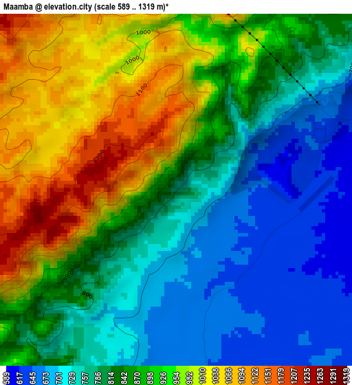
Below is the Elevation map of Maamba, which displays elevation range with different colors. Scale of the first map is from 589 to 1319 m (1932 to 4327 ft) with average elevation of 855 meters (=2805 ft) [note 1]
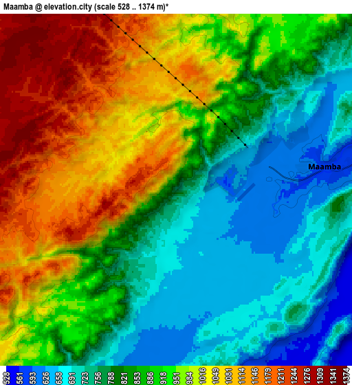
These maps also provides idea of topography and contour of this city, they are displayed at different zoom levels. More info about maps, scale and edge coordinates you can find below images.
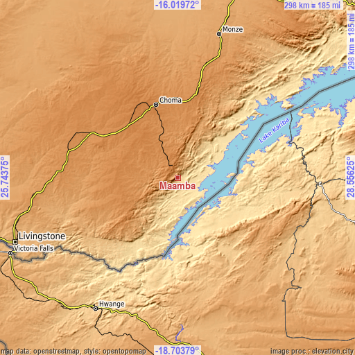
| \ | Map #1 | Map #2 | Topo.Map |
| Scale [m] | 589..1319 m | 528..1374 m | × |
| Scale [ft] | 1932..4327 ft | 1732..4508 ft | × |
| Average | 855 m = 2805 ft | 893.3 m = 2931 ft | × |
| Width | 9.33 km = 5.8 mi | 18.65 km = 11.6 mi | 298.4 km = 185.4 mi |
| Height | 9.33 km = 5.8 mi | 18.65 km = 11.6 mi | 298.5 km = 185.5 mi |
| ↑Max Latitude | -17.324723° | -17.282767° | -16.01972° |
| Latitude at center | -17.36667° | -17.36667° | -17.36667° |
| ↓Min Latitude | -17.408607° | -17.450535° | -18.70379° |
| ← Min Longitude | 27.106055° | 27.062109° | 25.74375° |
| Longitude center | 27.15° | 27.15° | 27.15° |
| →Max Longitude | 27.193945° | 27.237891° | 28.55625° |
Nearby cities:
Cities around Maamba sort by population:
• Lusaka elevation 1277 m
249.4 km,  29°
29°
• Livingstone 969 m
147.1 km,  248°
248°
• Mazabuka 1050 m
179.6 km,  20°
20°
• Kafue 996 m
208.9 km, 31°
• Choma 1317 m
64.4 km,  344°
344°
• Monze 1124 m
125.6 km, 16°
• Mumbwa 1185 m
265.2 km,  357°
357°
• Siavonga 528 m
189.7 km,  60°
60°
• Sinazongwe 504 m
35.1 km,  70°
70°
• Nakambala 1023 m
183.3 km, 21°
• Namwala 999 m
195.1 km, 337°
• Gwembe 1247 m
108.2 km, 26°
Multilingual:
 En español:
Maamba elevación 754 m.
 En France:
Maamba élévation 754 m.


Sources and notes:
- [note 1] Map square and city borders are not equal. Map elevation data is calculated only from area inside that square.
- [src 1] Elevation data from geonames database provided with same terms of usage.
- [src 2] The elevation map of Maamba is generated using elevation data from NASA's 3 arcsec (90m) resolution SRTM data.
- [src 3] Base (background) map © OpenStreetMap contributors tiles are generated by Geofabrik and OpenTopoMap.
Copyright & License:
This Maamba Elevation Map is licensed under CC BY-SA. You may reuse any part from this page, if you give a proper credit by linking to this URL:
 More info on terms of use page.