Sesheke elevation
Sesheke (Western), Zambia elevation is 951 meters and Sesheke elevation in feet is 3120 ft above sea level [src 1]. Sesheke is a populated place (feature code) with elevation that is 192 meters (630 ft) smaller than average city elevation in Zambia.
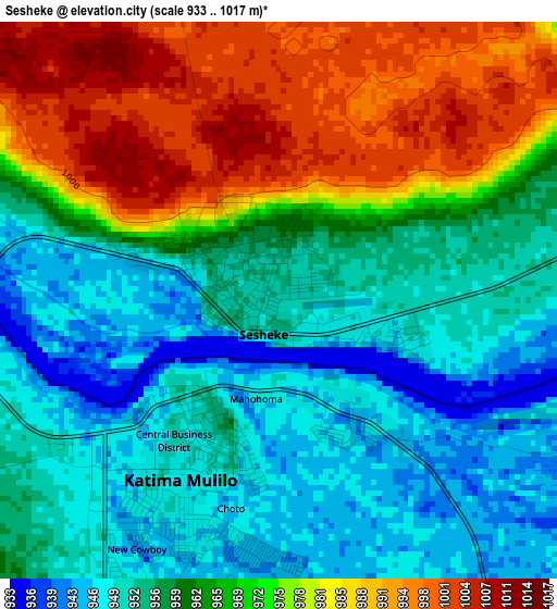
Below is the Elevation map of Sesheke, which displays elevation range with different colors. Scale of the first map is from 933 to 1017 m (3061 to 3337 ft) with average elevation of 964.9 meters (=3166 ft) [note 1]
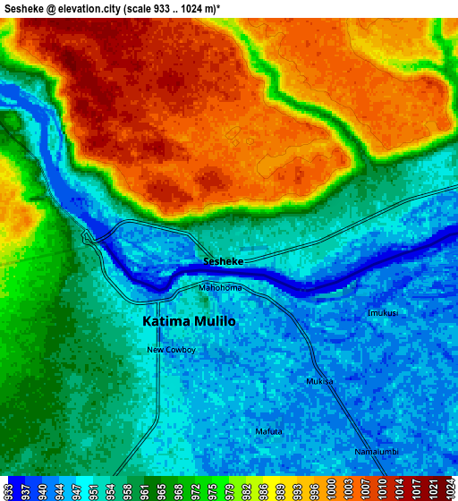
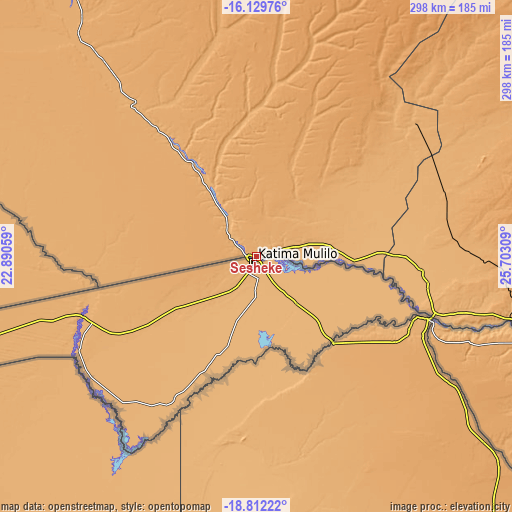
These maps also provides idea of topography and contour of this city, they are displayed at different zoom levels. More info about maps, scale and edge coordinates you can find below images.
| \ | Map #1 | Map #2 | Topo.Map |
| Scale [m] | 933..1017 m | 933..1024 m | × |
| Scale [ft] | 3061..3337 ft | 3061..3360 ft | × |
| Average | 964.9 m = 3166 ft | 967.7 m = 3175 ft | × |
| Width | 9.32 km = 5.8 mi | 18.64 km = 11.6 mi | 298.3 km = 185.4 mi |
| Height | 9.32 km = 5.8 mi | 18.64 km = 11.6 mi | 298.3 km = 185.4 mi |
| ↑Max Latitude | -17.434008° | -17.392077° | -16.12976° |
| Latitude at center | -17.47593° | -17.47593° | -17.47593° |
| ↓Min Latitude | -17.517842° | -17.559745° | -18.81222° |
| ← Min Longitude | 24.252895° | 24.208949° | 22.89059° |
| Longitude center | 24.29684° | 24.29684° | 24.29684° |
| →Max Longitude | 24.340785° | 24.384731° | 25.70309° |
Nearby cities:
Cities around Sesheke sort by population:
• Livingstone elevation 969 m
170 km,  103°
103°
• Mongu 1016 m
277.3 km,  333°
333°
• Choma 1317 m
295.3 km,  75°
75°
• Monze 1124 m
364 km,  68°
68°
• Kaoma 1126 m
304.2 km,  10°
10°
• Maamba 754 m
302.9 km,  87°
87°
• Sinazongwe 504 m
336.7 km, 85°
• Senanga 1001 m
186.7 km,  324°
324°
• Kalabo 1029 m
325.6 km, 327°
• Limulunga 1023 m
292 km, 334°
• Namwala 999 m
298.1 km,  49°
49°
• Lukulu 1048 m
363.2 km,  341°
341°
Multilingual:
 En español:
Sesheke elevación 951 m.
 En France:
Sesheke élévation 951 m.


Sources and notes:
- [note 1] Map square and city borders are not equal. Map elevation data is calculated only from area inside that square.
- [src 1] Elevation data from geonames database provided with same terms of usage.
- [src 2] The elevation map of Sesheke is generated using elevation data from NASA's 3 arcsec (90m) resolution SRTM data.
- [src 3] Base (background) map © OpenStreetMap contributors tiles are generated by Geofabrik and OpenTopoMap.
Copyright & License:
This Sesheke Elevation Map is licensed under CC BY-SA. You may reuse any part from this page, if you give a proper credit by linking to this URL:
 More info on terms of use page.