Ballito elevation
Ballito (KwaZulu-Natal, iLembe District Municipality), South Africa elevation is 51 meters and Ballito elevation in feet is 167 ft above sea level [src 1]. Ballito is a populated place (feature code) with elevation that is 921 meters (3022 ft) smaller than average city elevation in South Africa.
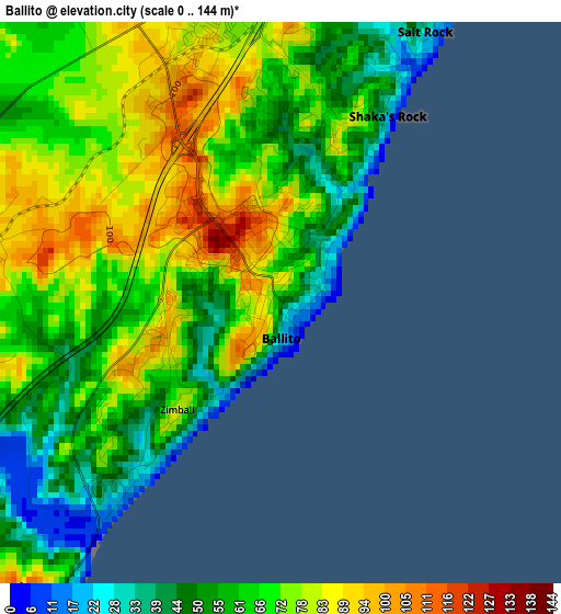
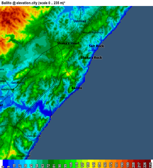
Below is the Elevation map of Ballito, which displays elevation range with different colors. Scale of the first map is from 0 to 144 m (0 to 472 ft) with average elevation of 66.4 meters (=218 ft) [note 1]
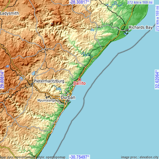
These maps also provides idea of topography and contour of this city, they are displayed at different zoom levels. More info about maps, scale and edge coordinates you can find below images.
| \ | Map #1 | Map #2 | Topo.Map |
| Scale [m] | 0..144 m | 0..235 m | × |
| Scale [ft] | 0..472 ft | 0..771 ft | × |
| Average | 66.4 m = 218 ft | 76.4 m = 251 ft | × |
| Width | 8.5 km = 5.3 mi | 17 km = 10.6 mi | 272.1 km = 169.1 mi |
| Height | 8.5 km = 5.3 mi | 17 km = 10.6 mi | 272.1 km = 169.1 mi |
| ↑Max Latitude | -29.500729° | -29.462474° | -28.30817° |
| Latitude at center | -29.53897° | -29.53897° | -29.53897° |
| ↓Min Latitude | -29.577196° | -29.615408° | -30.75497° |
| ← Min Longitude | 31.170445° | 31.126499° | 29.80814° |
| Longitude center | 31.21439° | 31.21439° | 31.21439° |
| →Max Longitude | 31.258335° | 31.302281° | 32.62064° |
Nearby cities:
Cities around Ballito sort by population:
• Durban elevation 21 m
39.7 km,  206°
206°
• Pietermaritzburg 636 m
79.9 km,  263°
263°
• Mpumalanga 711 m
63.6 km,  241°
241°
• KwaDukuza 111 m
24.5 km,  17°
17°
• Berea 92 m
40.8 km, 211°
• Eshowe 539 m
76.7 km, 18°
• Greytown 1050 m
80.1 km,  311°
311°
• Sundumbili 64 m
48.4 km, 21°
• Camperdown 764 m
68.3 km,  252°
252°
• Wartburg 950 m
63 km,  280°
280°
• Mandeni 88 m
47.7 km, 23°
• Ndwedwe 514 m
27.9 km, 275°
Multilingual:
 En español:
Ballito elevación 51 m.
 En France:
Ballito élévation 51 m.


Sources and notes:
- [note 1] Map square and city borders are not equal. Map elevation data is calculated only from area inside that square.
- [src 1] Elevation data from geonames database provided with same terms of usage.
- [src 2] The elevation map of Ballito is generated using elevation data from NASA's 3 arcsec (90m) resolution SRTM data.
- [src 3] Base (background) map © OpenStreetMap contributors tiles are generated by Geofabrik and OpenTopoMap.
Copyright & License:
This Ballito Elevation Map is licensed under CC BY-SA. You may reuse any part from this page, if you give a proper credit by linking to this URL:
 More info on terms of use page.