Greytown elevation
Greytown (KwaZulu-Natal, uMzinyathi District Municipality), South Africa elevation is 1050 meters and Greytown elevation in feet is 3445 ft above sea level [src 1]. Greytown is a seat of a third-order administrative division (feature code) with elevation that is 78 meters (256 ft) bigger than average city elevation in South Africa.
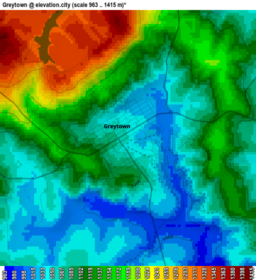
Below is the Elevation map of Greytown, which displays elevation range with different colors. Scale of the first map is from 963 to 1415 m (3159 to 4642 ft) with average elevation of 1112.2 meters (=3649 ft) [note 1]
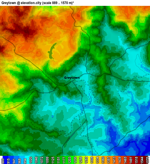
These maps also provides idea of topography and contour of this city, they are displayed at different zoom levels. More info about maps, scale and edge coordinates you can find below images.
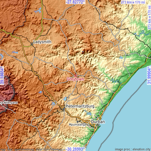
| \ | Map #1 | Map #2 | Topo.Map |
| Scale [m] | 963..1415 m | 889..1570 m | × |
| Scale [ft] | 3159..4642 ft | 2917..5151 ft | × |
| Average | 1112.2 m = 3649 ft | 1153.1 m = 3783 ft | × |
| Width | 8.54 km = 5.3 mi | 17.08 km = 10.6 mi | 273.3 km = 169.8 mi |
| Height | 8.54 km = 5.3 mi | 17.08 km = 10.6 mi | 273.3 km = 169.8 mi |
| ↑Max Latitude | -29.025731° | -28.987298° | -27.82772° |
| Latitude at center | -29.06415° | -29.06415° | -29.06415° |
| ↓Min Latitude | -29.102554° | -29.140944° | -30.28593° |
| ← Min Longitude | 30.548845° | 30.504899° | 29.18654° |
| Longitude center | 30.59279° | 30.59279° | 30.59279° |
| →Max Longitude | 30.636735° | 30.680681° | 31.99904° |
Nearby cities:
Cities around Greytown sort by population:
• Pietermaritzburg elevation 636 m
64.4 km,  197°
197°
• KwaDukuza 111 m
73.7 km,  113°
113°
• Howick 1048 m
57.9 km,  217°
217°
• Mpophomeni 1103 m
68.5 km, 215°
• Sundumbili 64 m
78.6 km,  95°
95°
• Mooirivier 1403 m
60.3 km,  254°
254°
• Camperdown 764 m
74 km,  183°
183°
• Estcourt 1214 m
70.9 km,  274°
274°
• Nkandla 1112 m
69.2 km,  44°
44°
• Ndwedwe 514 m
59.9 km,  147°
147°
• Wartburg 950 m
40.9 km, 182°
• Tugela Ferry 559 m
37.9 km,  338°
338°
Multilingual:
 En español:
Greytown elevación 1050 m.
 En France:
Greytown élévation 1050 m.
 Auf Deutsch:
Greytown höhe über dem Meeresspiegel ist 1050 m.

Sources and notes:
- [note 1] Map square and city borders are not equal. Map elevation data is calculated only from area inside that square.
- [src 1] Elevation data from geonames database provided with same terms of usage.
- [src 2] The elevation map of Greytown is generated using elevation data from NASA's 3 arcsec (90m) resolution SRTM data.
- [src 3] Base (background) map © OpenStreetMap contributors tiles are generated by Geofabrik and OpenTopoMap.
Copyright & License:
This Greytown Elevation Map is licensed under CC BY-SA. You may reuse any part from this page, if you give a proper credit by linking to this URL:
 More info on terms of use page.