De Aar elevation
De Aar (Northern Cape, Pixley ka Seme District Municipality), South Africa elevation is 1247 meters and De Aar elevation in feet is 4091 ft above sea level [src 1]. De Aar is a seat of a second-order administrative division (feature code) with elevation that is 275 meters (902 ft) bigger than average city elevation in South Africa.
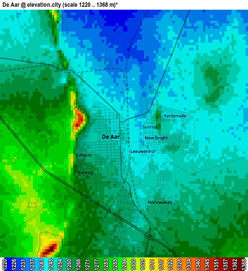
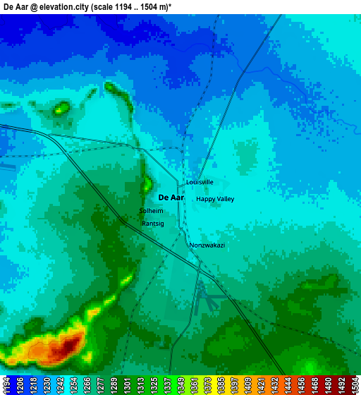
Below is the Elevation map of De Aar, which displays elevation range with different colors. Scale of the first map is from 1220 to 1368 m (4003 to 4488 ft) with average elevation of 1257.8 meters (=4127 ft) [note 1]
These maps also provides idea of topography and contour of this city, they are displayed at different zoom levels. More info about maps, scale and edge coordinates you can find below images.
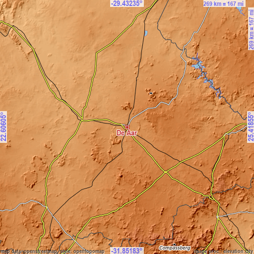
| \ | Map #1 | Map #2 | Topo.Map |
| Scale [m] | 1220..1368 m | 1194..1504 m | × |
| Scale [ft] | 4003..4488 ft | 3917..4934 ft | × |
| Average | 1257.8 m = 4127 ft | 1257.4 m = 4125 ft | × |
| Width | 8.41 km = 5.2 mi | 16.81 km = 10.4 mi | 269 km = 167.1 mi |
| Height | 8.41 km = 5.2 mi | 16.81 km = 10.4 mi | 269 km = 167.1 mi |
| ↑Max Latitude | -30.611846° | -30.574018° | -29.43235° |
| Latitude at center | -30.64966° | -30.64966° | -30.64966° |
| ↓Min Latitude | -30.687459° | -30.725243° | -31.85183° |
| ← Min Longitude | 23.968355° | 23.924409° | 22.60605° |
| Longitude center | 24.0123° | 24.0123° | 24.0123° |
| →Max Longitude | 24.056245° | 24.100191° | 25.41855° |
Nearby cities:
Cities around De Aar sort by population:
• Middelburg elevation 1253 m
133.2 km,  134°
134°
• Colesberg 1369 m
104 km,  94°
94°
• Prieska 942 m
163.8 km,  311°
311°
• Carnarvon 1249 m
182.9 km,  258°
258°
• Noupoort 1496 m
107.6 km,  123°
123°
• Orania 1111 m
100.6 km,  22°
22°
• Trompsburg 1418 m
183 km,  68°
68°
• Douglas 992 m
178.8 km,  352°
352°
• Koffiefontein 1188 m
167.9 km,  34°
34°
• Victoria West 1277 m
119.8 km,  225°
225°
• Hopetown 1095 m
114.2 km,  3°
3°
• Petrusville 1199 m
88.6 km,  44°
44°
Multilingual:
 En español:
De Aar elevación 1247 m.
 En France:
De Aar élévation 1247 m.


Sources and notes:
- [note 1] Map square and city borders are not equal. Map elevation data is calculated only from area inside that square.
- [src 1] Elevation data from geonames database provided with same terms of usage.
- [src 2] The elevation map of De Aar is generated using elevation data from NASA's 3 arcsec (90m) resolution SRTM data.
- [src 3] Base (background) map © OpenStreetMap contributors tiles are generated by Geofabrik and OpenTopoMap.
Copyright & License:
This De Aar Elevation Map is licensed under CC BY-SA. You may reuse any part from this page, if you give a proper credit by linking to this URL:
 More info on terms of use page.