Kokstad elevation
Kokstad (KwaZulu-Natal, Sisonke District Municipality), South Africa elevation is 1316 meters and Kokstad elevation in feet is 4318 ft above sea level [src 1]. Kokstad is a seat of a third-order administrative division (feature code) with elevation that is 344 meters (1129 ft) bigger than average city elevation in South Africa.
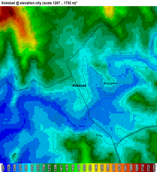
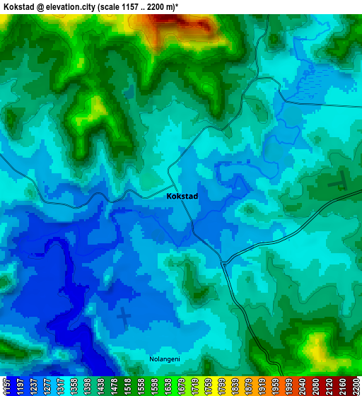
Below is the Elevation map of Kokstad, which displays elevation range with different colors. Scale of the first map is from 1207 to 1752 m (3960 to 5748 ft) with average elevation of 1335.2 meters (=4381 ft) [note 1]
These maps also provides idea of topography and contour of this city, they are displayed at different zoom levels. More info about maps, scale and edge coordinates you can find below images.
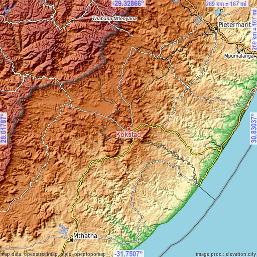
| \ | Map #1 | Map #2 | Topo.Map |
| Scale [m] | 1207..1752 m | 1157..2200 m | × |
| Scale [ft] | 3960..5748 ft | 3796..7218 ft | × |
| Average | 1335.2 m = 4381 ft | 1389 m = 4557 ft | × |
| Width | 8.42 km = 5.2 mi | 16.83 km = 10.5 mi | 269.3 km = 167.3 mi |
| Height | 8.42 km = 5.2 mi | 16.83 km = 10.5 mi | 269.3 km = 167.3 mi |
| ↑Max Latitude | -30.509376° | -30.471508° | -29.32866° |
| Latitude at center | -30.54723° | -30.54723° | -30.54723° |
| ↓Min Latitude | -30.585069° | -30.622893° | -31.7507° |
| ← Min Longitude | 29.380175° | 29.336229° | 28.01787° |
| Longitude center | 29.42412° | 29.42412° | 29.42412° |
| →Max Longitude | 29.468065° | 29.512011° | 30.83037° |
Nearby cities:
Cities around Kokstad sort by population:
• Margate elevation 20 m
97.1 km,  111°
111°
• Himeville 1554 m
89.4 km,  5°
5°
• Qumbu 992 m
86.5 km,  217°
217°
• Ixopo 986 m
77.1 km,  55°
55°
• Izingolweni 584 m
71.8 km, 111°
• Creighton 1006 m
70.2 km,  34°
34°
• Matatiele 1489 m
62.9 km,  291°
291°
• Flagstaff 907 m
59.7 km,  173°
173°
• Mount Frere 1153 m
57.1 km,  226°
226°
• Bizana 828 m
53.8 km,  130°
130°
• Harding 851 m
44.2 km,  94°
94°
• Mount Ayliff 1039 m
29.5 km,  190°
190°
Multilingual:
 En español:
Kokstad elevación 1316 m.
 En France:
Kokstad élévation 1316 m.
 Auf Deutsch:
Kokstad höhe über dem Meeresspiegel ist 1316 m.

Sources and notes:
- [note 1] Map square and city borders are not equal. Map elevation data is calculated only from area inside that square.
- [src 1] Elevation data from geonames database provided with same terms of usage.
- [src 2] The elevation map of Kokstad is generated using elevation data from NASA's 3 arcsec (90m) resolution SRTM data.
- [src 3] Base (background) map © OpenStreetMap contributors tiles are generated by Geofabrik and OpenTopoMap.
Copyright & License:
This Kokstad Elevation Map is licensed under CC BY-SA. You may reuse any part from this page, if you give a proper credit by linking to this URL:
 More info on terms of use page.