Margate elevation
Margate (KwaZulu-Natal, Ugu District Municipality), South Africa elevation is 20 meters and Margate elevation in feet is 66 ft above sea level [src 1]. Margate is a populated place (feature code) with elevation that is 952 meters (3123 ft) smaller than average city elevation in South Africa.
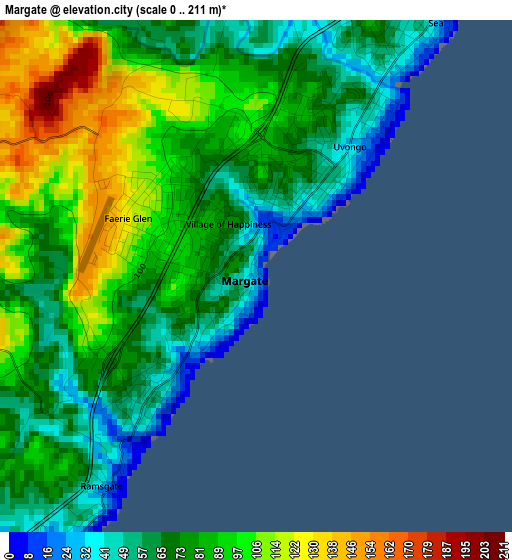
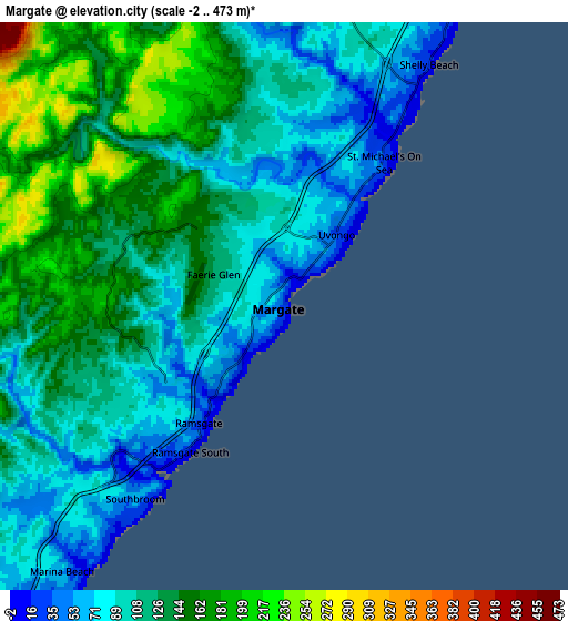
Below is the Elevation map of Margate, which displays elevation range with different colors. Scale of the first map is from 0 to 211 m (0 to 692 ft) with average elevation of 81.1 meters (=266 ft) [note 1]
These maps also provides idea of topography and contour of this city, they are displayed at different zoom levels. More info about maps, scale and edge coordinates you can find below images.
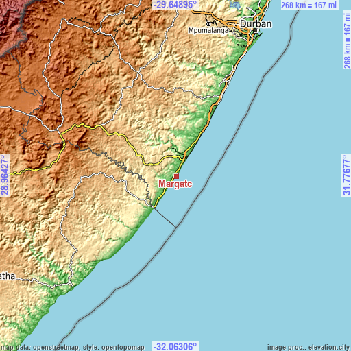
| \ | Map #1 | Map #2 | Topo.Map |
| Scale [m] | 0..211 m | -2..473 m | × |
| Scale [ft] | 0..692 ft | -7..1552 ft | × |
| Average | 81.1 m = 266 ft | 118.8 m = 390 ft | × |
| Width | 8.39 km = 5.2 mi | 16.78 km = 10.4 mi | 268.4 km = 166.8 mi |
| Height | 8.39 km = 5.2 mi | 16.78 km = 10.4 mi | 268.4 km = 166.8 mi |
| ↑Max Latitude | -30.82587° | -30.788126° | -29.64895° |
| Latitude at center | -30.8636° | -30.8636° | -30.8636° |
| ↓Min Latitude | -30.901315° | -30.939015° | -32.06306° |
| ← Min Longitude | 30.326575° | 30.282629° | 28.96427° |
| Longitude center | 30.37052° | 30.37052° | 30.37052° |
| →Max Longitude | 30.414465° | 30.458411° | 31.77677° |
Nearby cities:
Cities around Margate sort by population:
• Port Shepstone elevation 36 m
15.8 km,  30°
30°
• Richmond 883 m
110.7 km,  355°
355°
• Kokstad 1316 m
97.1 km,  291°
291°
• Scottburgh 48 m
73.9 km, 29°
• eMkhomazi 41 m
83.7 km, 29°
• Creighton 1006 m
106 km,  331°
331°
• Mount Ayliff 1039 m
96.1 km,  273°
273°
• Flagstaff 907 m
86.9 km,  253°
253°
• Ixopo 986 m
84 km,  340°
340°
• Harding 851 m
56.4 km,  304°
304°
• Bizana 828 m
49.3 km, 270°
• Izingolweni 584 m
25.2 km, 290°
Multilingual:
 En español:
Margate elevación 20 m.
 En France:
Margate élévation 20 m.


Sources and notes:
- [note 1] Map square and city borders are not equal. Map elevation data is calculated only from area inside that square.
- [src 1] Elevation data from geonames database provided with same terms of usage.
- [src 2] The elevation map of Margate is generated using elevation data from NASA's 3 arcsec (90m) resolution SRTM data.
- [src 3] Base (background) map © OpenStreetMap contributors tiles are generated by Geofabrik and OpenTopoMap.
Copyright & License:
This Margate Elevation Map is licensed under CC BY-SA. You may reuse any part from this page, if you give a proper credit by linking to this URL:
 More info on terms of use page.