Mmabatho elevation
Mmabatho (North-West, Ngaka Modiri Molema District Municipality), South Africa elevation is 1282 meters and Mmabatho elevation in feet is 4206 ft above sea level [src 1]. Mmabatho is a section of populated place (feature code) with elevation that is 310 meters (1017 ft) bigger than average city elevation in South Africa.
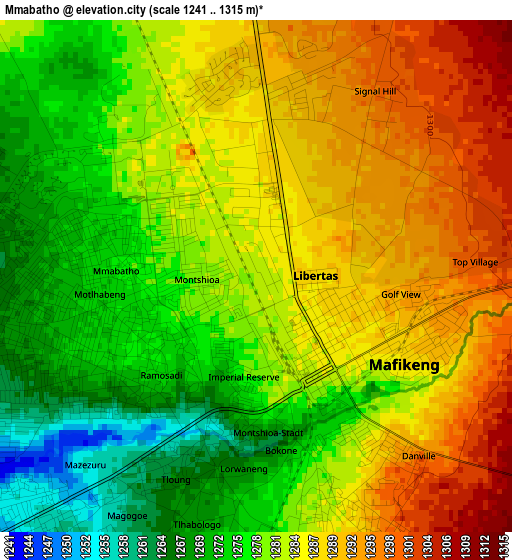
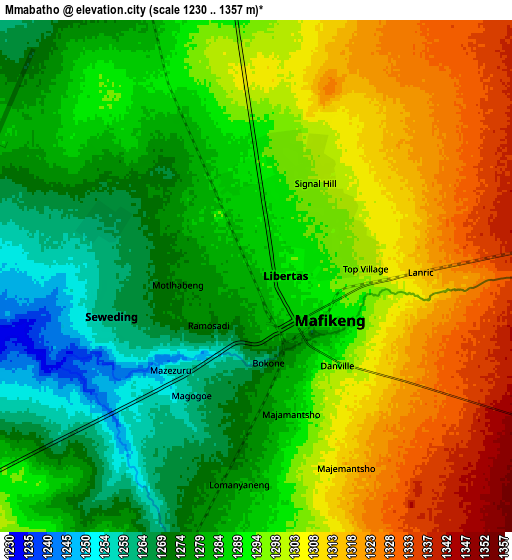
Below is the Elevation map of Mmabatho, which displays elevation range with different colors. Scale of the first map is from 1241 to 1315 m (4072 to 4314 ft) with average elevation of 1281.9 meters (=4206 ft) [note 1]
These maps also provides idea of topography and contour of this city, they are displayed at different zoom levels. More info about maps, scale and edge coordinates you can find below images.
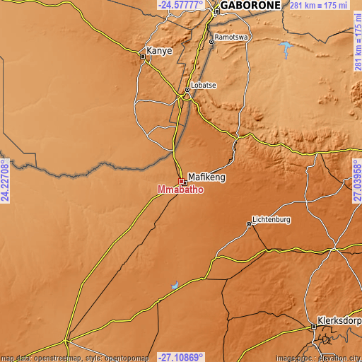
| \ | Map #1 | Map #2 | Topo.Map |
| Scale [m] | 1241..1315 m | 1230..1357 m | × |
| Scale [ft] | 4072..4314 ft | 4035..4452 ft | × |
| Average | 1281.9 m = 4206 ft | 1292.2 m = 4240 ft | × |
| Width | 8.79 km = 5.5 mi | 17.59 km = 10.9 mi | 281.4 km = 174.9 mi |
| Height | 8.79 km = 5.5 mi | 17.59 km = 10.9 mi | 281.4 km = 174.9 mi |
| ↑Max Latitude | -25.810445° | -25.770877° | -24.57777° |
| Latitude at center | -25.85° | -25.85° | -25.85° |
| ↓Min Latitude | -25.889541° | -25.92907° | -27.10869° |
| ← Min Longitude | 25.589385° | 25.545439° | 24.22708° |
| Longitude center | 25.63333° | 25.63333° | 25.63333° |
| →Max Longitude | 25.677275° | 25.721221° | 27.03958° |
Nearby cities:
Cities around Mmabatho sort by population:
• Klerksdorp elevation 1318 m
151.7 km,  137°
137°
• Rustenburg 1171 m
162.4 km,  82°
82°
• Stilfontein 1357 m
158.2 km,  134°
134°
• Schweizer-Reneke 1312 m
151.9 km,  191°
191°
• Lichtenburg 1486 m
62.4 km,  122°
122°
• Vryburg 1202 m
152.5 km,  216°
216°
• Wolmaransstad 1357 m
153.8 km,  166°
166°
• Zeerust 1213 m
56.3 km,  51°
51°
• Mahikeng 1284 m
2 km,  147°
147°
• Koster 1620 m
126.5 km,  90°
90°
• Ventersdorp 1485 m
129.5 km,  113°
113°
• Delareyville 1359 m
94.6 km, 190°
Multilingual:
 En español:
Mmabatho elevación 1282 m.
 En France:
Mmabatho élévation 1282 m.
 Auf Deutsch:
Mmabatho höhe über dem Meeresspiegel ist 1282 m.

Sources and notes:
- [note 1] Map square and city borders are not equal. Map elevation data is calculated only from area inside that square.
- [src 1] Elevation data from geonames database provided with same terms of usage.
- [src 2] The elevation map of Mmabatho is generated using elevation data from NASA's 3 arcsec (90m) resolution SRTM data.
- [src 3] Base (background) map © OpenStreetMap contributors tiles are generated by Geofabrik and OpenTopoMap.
Copyright & License:
This Mmabatho Elevation Map is licensed under CC BY-SA. You may reuse any part from this page, if you give a proper credit by linking to this URL:
 More info on terms of use page.