Vryburg elevation
Vryburg (North-West, Dr Ruth Segomotsi Mompati District Municipality), South Africa elevation is 1202 meters and Vryburg elevation in feet is 3944 ft above sea level [src 1]. Vryburg is a seat of a second-order administrative division (feature code) with elevation that is 230 meters (755 ft) bigger than average city elevation in South Africa.
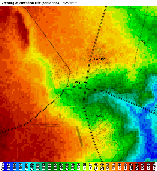
Below is the Elevation map of Vryburg, which displays elevation range with different colors. Scale of the first map is from 1164 to 1239 m (3819 to 4065 ft) with average elevation of 1209.9 meters (=3969 ft) [note 1]
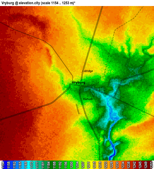
These maps also provides idea of topography and contour of this city, they are displayed at different zoom levels. More info about maps, scale and edge coordinates you can find below images.
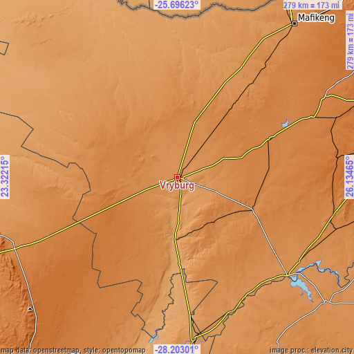
| \ | Map #1 | Map #2 | Topo.Map |
| Scale [m] | 1164..1239 m | 1154..1253 m | × |
| Scale [ft] | 3819..4065 ft | 3786..4111 ft | × |
| Average | 1209.9 m = 3969 ft | 1217.9 m = 3996 ft | × |
| Width | 8.71 km = 5.4 mi | 17.42 km = 10.8 mi | 278.7 km = 173.2 mi |
| Height | 8.71 km = 5.4 mi | 17.42 km = 10.8 mi | 278.7 km = 173.2 mi |
| ↑Max Latitude | -26.917413° | -26.878221° | -25.69623° |
| Latitude at center | -26.95659° | -26.95659° | -26.95659° |
| ↓Min Latitude | -26.995754° | -27.034904° | -28.20301° |
| ← Min Longitude | 24.684455° | 24.640509° | 23.32215° |
| Longitude center | 24.7284° | 24.7284° | 24.7284° |
| →Max Longitude | 24.772345° | 24.816291° | 26.13465° |
Nearby cities:
Cities around Vryburg sort by population:
• Schweizer-Reneke elevation 1312 m
64.9 km,  113°
113°
• Wolmaransstad 1357 m
127.1 km,  102°
102°
• Pampierstad 1078 m
92 km,  182°
182°
• Warrenton 1190 m
129.2 km,  174°
174°
• Christiana 1207 m
114.7 km,  158°
158°
• Bloemhof 1236 m
115.9 km,  131°
131°
• Jan Kempdorp 1159 m
107.9 km, 174°
• Kuruman 1323 m
139.5 km,  246°
246°
• Hartswater 1125 m
88.4 km, 175°
• Delareyville 1359 m
78.5 km,  67°
67°
• Ganyesa 1282 m
67.9 km,  306°
306°
• Taung 1118 m
64.1 km, 174°
Multilingual:
 En español:
Vryburg elevación 1202 m.
 En France:
Vryburg élévation 1202 m.
 Auf Deutsch:
Vryburg höhe über dem Meeresspiegel ist 1202 m.
 На русском:
Фрейбурга, Фрейбург высота над уровнем моря 1202 м
Sources and notes:
- [note 1] Map square and city borders are not equal. Map elevation data is calculated only from area inside that square.
- [src 1] Elevation data from geonames database provided with same terms of usage.
- [src 2] The elevation map of Vryburg is generated using elevation data from NASA's 3 arcsec (90m) resolution SRTM data.
- [src 3] Base (background) map © OpenStreetMap contributors tiles are generated by Geofabrik and OpenTopoMap.
Copyright & License:
This Vryburg Elevation Map is licensed under CC BY-SA. You may reuse any part from this page, if you give a proper credit by linking to this URL:
 More info on terms of use page.