Potchefstroom elevation
Potchefstroom (North-West, Dr Kenneth Kaunda District Municipality), South Africa elevation is 1335 meters and Potchefstroom elevation in feet is 4380 ft above sea level [src 1]. Potchefstroom is a seat of a third-order administrative division (feature code) with elevation that is 363 meters (1191 ft) bigger than average city elevation in South Africa.
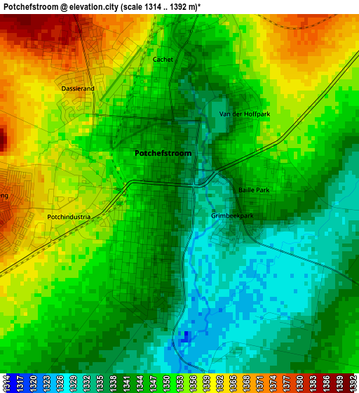
Below is the Elevation map of Potchefstroom, which displays elevation range with different colors. Scale of the first map is from 1314 to 1392 m (4311 to 4567 ft) with average elevation of 1347.3 meters (=4420 ft) [note 1]
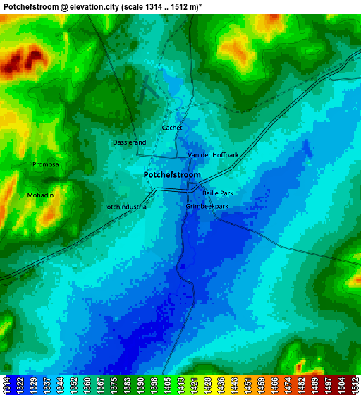
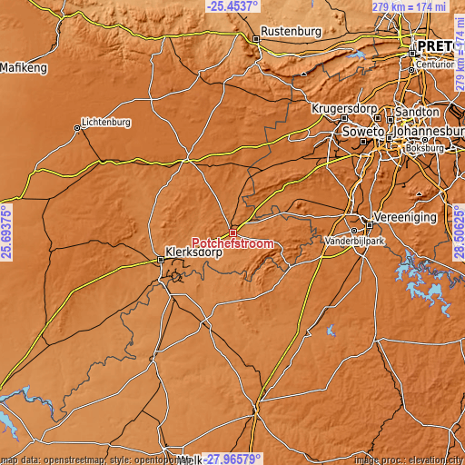
These maps also provides idea of topography and contour of this city, they are displayed at different zoom levels. More info about maps, scale and edge coordinates you can find below images.
| \ | Map #1 | Map #2 | Topo.Map |
| Scale [m] | 1314..1392 m | 1314..1512 m | × |
| Scale [ft] | 4311..4567 ft | 4311..4961 ft | × |
| Average | 1347.3 m = 4420 ft | 1365.3 m = 4479 ft | × |
| Width | 8.73 km = 5.4 mi | 17.46 km = 10.8 mi | 279.3 km = 173.5 mi |
| Height | 8.73 km = 5.4 mi | 17.46 km = 10.8 mi | 279.3 km = 173.5 mi |
| ↑Max Latitude | -26.677409° | -26.638135° | -25.4537° |
| Latitude at center | -26.71667° | -26.71667° | -26.71667° |
| ↓Min Latitude | -26.755917° | -26.79515° | -27.96579° |
| ← Min Longitude | 27.056055° | 27.012109° | 25.69375° |
| Longitude center | 27.1° | 27.1° | 27.1° |
| →Max Longitude | 27.143945° | 27.187891° | 28.50625° |
Nearby cities:
Cities around Potchefstroom sort by population:
• Vanderbijlpark elevation 1485 m
73.3 km,  89°
89°
• Carletonville 1529 m
49.4 km,  36°
36°
• Klerksdorp 1318 m
45.6 km,  250°
250°
• Westonaria 1593 m
70.2 km,  50°
50°
• Orkney 1312 m
51.5 km,  235°
235°
• Stilfontein 1357 m
35.9 km, 246°
• Sasolburg 1473 m
72 km,  98°
98°
• Parys 1398 m
41.1 km,  120°
120°
• Fochville 1478 m
46.7 km,  57°
57°
• Viljoenskroon 1345 m
56.7 km,  195°
195°
• Vredefort 1425 m
41.7 km,  140°
140°
• Ventersdorp 1485 m
52.6 km,  328°
328°
Multilingual:
 En español:
Potchefstroom elevación 1335 m.
 En France:
Potchefstroom élévation 1335 m.
 Auf Deutsch:
Potchefstroom höhe über dem Meeresspiegel ist 1335 m.
 На русском:
Почефструм, Потчефструм высота над уровнем моря 1335 м
Sources and notes:
- [note 1] Map square and city borders are not equal. Map elevation data is calculated only from area inside that square.
- [src 1] Elevation data from geonames database provided with same terms of usage.
- [src 2] The elevation map of Potchefstroom is generated using elevation data from NASA's 3 arcsec (90m) resolution SRTM data.
- [src 3] Base (background) map © OpenStreetMap contributors tiles are generated by Geofabrik and OpenTopoMap.
Copyright & License:
This Potchefstroom Elevation Map is licensed under CC BY-SA. You may reuse any part from this page, if you give a proper credit by linking to this URL:
 More info on terms of use page.