Vanderbijlpark elevation
Vanderbijlpark (Gauteng, Sedibeng District Municipality), South Africa elevation is 1485 meters and Vanderbijlpark elevation in feet is 4872 ft above sea level [src 1]. Vanderbijlpark is a seat of a third-order administrative division (feature code) with elevation that is 513 meters (1683 ft) bigger than average city elevation in South Africa.
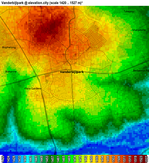
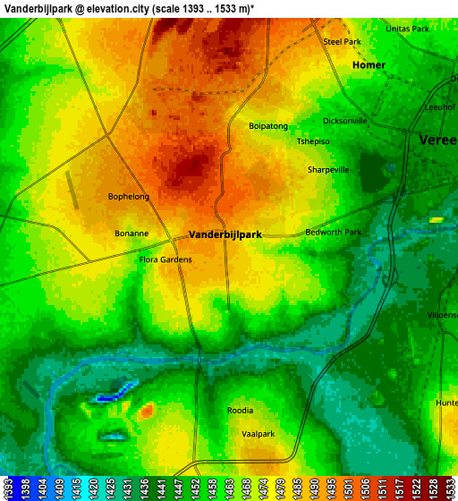
Below is the Elevation map of Vanderbijlpark, which displays elevation range with different colors. Scale of the first map is from 1420 to 1527 m (4659 to 5010 ft) with average elevation of 1473.5 meters (=4834 ft) [note 1]
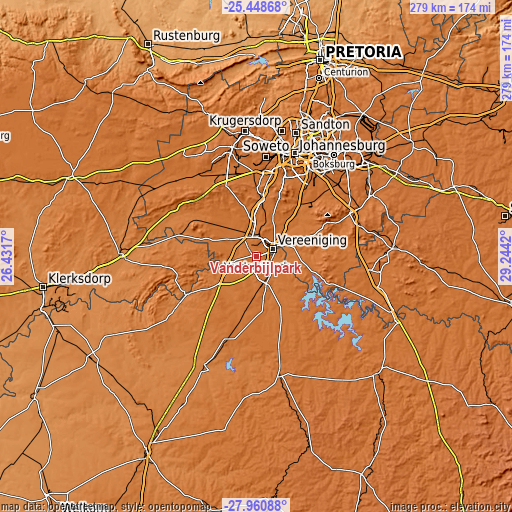
These maps also provides idea of topography and contour of this city, they are displayed at different zoom levels. More info about maps, scale and edge coordinates you can find below images.
| \ | Map #1 | Map #2 | Topo.Map |
| Scale [m] | 1420..1527 m | 1393..1533 m | × |
| Scale [ft] | 4659..5010 ft | 4570..5030 ft | × |
| Average | 1473.5 m = 4834 ft | 1463.1 m = 4800 ft | × |
| Width | 8.73 km = 5.4 mi | 17.46 km = 10.8 mi | 279.3 km = 173.5 mi |
| Height | 8.73 km = 5.4 mi | 17.46 km = 10.8 mi | 279.3 km = 173.5 mi |
| ↑Max Latitude | -26.672448° | -26.633172° | -25.44868° |
| Latitude at center | -26.71171° | -26.71171° | -26.71171° |
| ↓Min Latitude | -26.750959° | -26.790194° | -27.96088° |
| ← Min Longitude | 27.794005° | 27.750059° | 26.4317° |
| Longitude center | 27.83795° | 27.83795° | 27.83795° |
| →Max Longitude | 27.881895° | 27.925841° | 29.2442° |
Nearby cities:
Cities around Vanderbijlpark sort by population:
• Soweto elevation 1632 m
49.4 km,  2°
2°
• Vereeniging 1445 m
9.8 km,  63°
63°
• Westonaria 1593 m
47.6 km,  336°
336°
• Alberton 1574 m
56.9 km,  29°
29°
• Sasolburg 1473 m
11.5 km,  190°
190°
• Parys 1398 m
43.4 km,  240°
240°
• Heidelberg 1525 m
56.7 km,  66°
66°
• Fochville 1478 m
42.3 km,  305°
305°
• Deneysville 1513 m
32.5 km,  127°
127°
• Orange Farm 1572 m
25.6 km,  6°
6°
• Riverlea 1690 m
57.2 km, 13°
• Meyerton 1473 m
24.7 km,  46°
46°
Multilingual:
 En español:
Vanderbijlpark elevación 1485 m.
 En France:
Vanderbijlpark élévation 1485 m.
 Auf Deutsch:
Vanderbijlpark höhe über dem Meeresspiegel ist 1485 m.

Sources and notes:
- [note 1] Map square and city borders are not equal. Map elevation data is calculated only from area inside that square.
- [src 1] Elevation data from geonames database provided with same terms of usage.
- [src 2] The elevation map of Vanderbijlpark is generated using elevation data from NASA's 3 arcsec (90m) resolution SRTM data.
- [src 3] Base (background) map © OpenStreetMap contributors tiles are generated by Geofabrik and OpenTopoMap.
Copyright & License:
This Vanderbijlpark Elevation Map is licensed under CC BY-SA. You may reuse any part from this page, if you give a proper credit by linking to this URL:
 More info on terms of use page.