Randfontein elevation
Randfontein (Gauteng, West Rand District Municipality), South Africa elevation is 1716 meters and Randfontein elevation in feet is 5630 ft above sea level [src 1]. Randfontein is a seat of a second-order administrative division (feature code) with elevation that is 744 meters (2441 ft) bigger than average city elevation in South Africa.
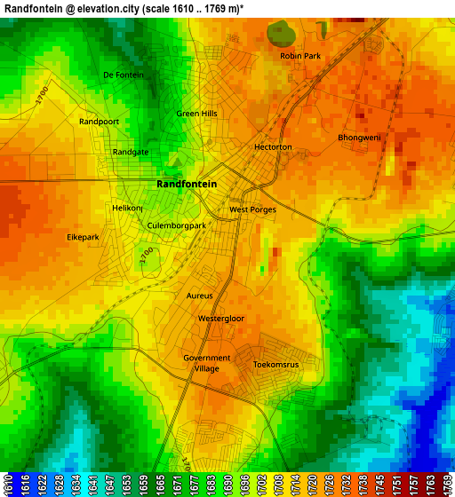
Below is the Elevation map of Randfontein, which displays elevation range with different colors. Scale of the first map is from 1610 to 1769 m (5282 to 5804 ft) with average elevation of 1698.6 meters (=5573 ft) [note 1]
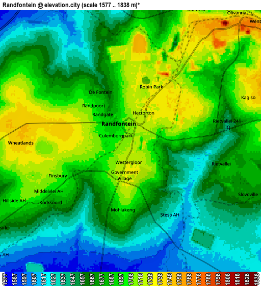
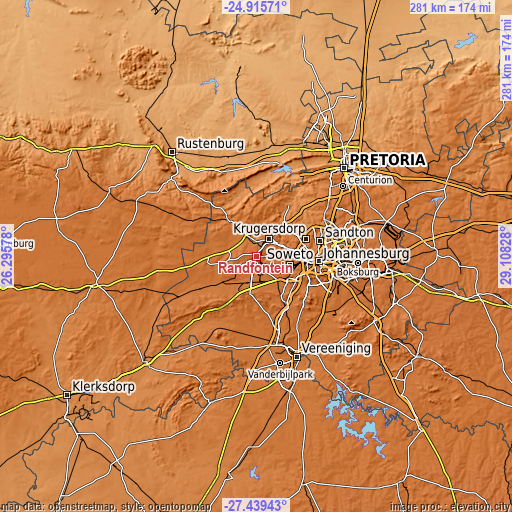
These maps also provides idea of topography and contour of this city, they are displayed at different zoom levels. More info about maps, scale and edge coordinates you can find below images.
| \ | Map #1 | Map #2 | Topo.Map |
| Scale [m] | 1610..1769 m | 1577..1838 m | × |
| Scale [ft] | 5282..5804 ft | 5174..6030 ft | × |
| Average | 1698.6 m = 5573 ft | 1676.8 m = 5501 ft | × |
| Width | 8.77 km = 5.4 mi | 17.54 km = 10.9 mi | 280.6 km = 174.4 mi |
| Height | 8.77 km = 5.4 mi | 17.54 km = 10.9 mi | 280.6 km = 174.4 mi |
| ↑Max Latitude | -26.144958° | -26.105502° | -24.91571° |
| Latitude at center | -26.1844° | -26.1844° | -26.1844° |
| ↓Min Latitude | -26.223829° | -26.263244° | -27.43943° |
| ← Min Longitude | 27.658085° | 27.614139° | 26.29578° |
| Longitude center | 27.70203° | 27.70203° | 27.70203° |
| →Max Longitude | 27.745975° | 27.789921° | 29.10828° |
Nearby cities:
Cities around Randfontein sort by population:
• Johannesburg elevation 1767 m
34.1 km,  93°
93°
• Soweto 1632 m
18.2 km,  120°
120°
• Krugersdorp 1724 m
13.2 km,  33°
33°
• Diepsloot 1410 m
41.7 km,  47°
47°
• Randburg 1593 m
31.5 km,  71°
71°
• Roodepoort 1738 m
17.2 km,  81°
81°
• Carletonville 1529 m
36.1 km,  237°
237°
• Westonaria 1593 m
15.9 km,  199°
199°
• Fochville 1478 m
39.7 km,  211°
211°
• Orange Farm 1572 m
37.1 km,  153°
153°
• Muldersdriseloop 1441 m
21.3 km,  39°
39°
• Riverlea 1690 m
27.2 km,  96°
96°
Multilingual:
 En español:
Randfontein elevación 1716 m.
 En France:
Randfontein élévation 1716 m.
 Auf Deutsch:
Randfontein höhe über dem Meeresspiegel ist 1716 m.

Sources and notes:
- [note 1] Map square and city borders are not equal. Map elevation data is calculated only from area inside that square.
- [src 1] Elevation data from geonames database provided with same terms of usage.
- [src 2] The elevation map of Randfontein is generated using elevation data from NASA's 3 arcsec (90m) resolution SRTM data.
- [src 3] Base (background) map © OpenStreetMap contributors tiles are generated by Geofabrik and OpenTopoMap.
Copyright & License:
This Randfontein Elevation Map is licensed under CC BY-SA. You may reuse any part from this page, if you give a proper credit by linking to this URL:
 More info on terms of use page.