Randburg elevation
Randburg (Gauteng, City of Johannesburg Metropolitan Municipality), South Africa elevation is 1593 meters and Randburg elevation in feet is 5226 ft above sea level [src 1]. Randburg is a populated place (feature code) with elevation that is 621 meters (2037 ft) bigger than average city elevation in South Africa.
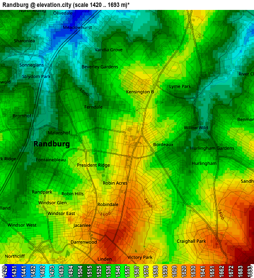
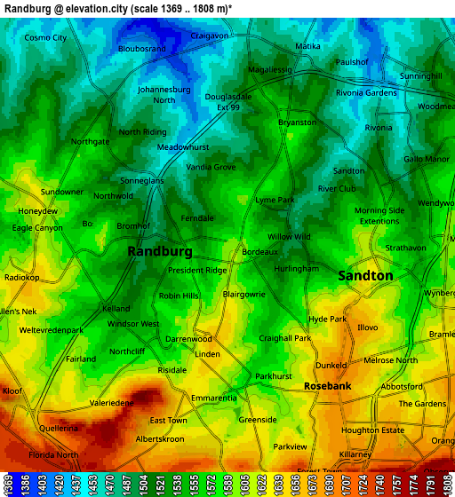
Below is the Elevation map of Randburg, which displays elevation range with different colors. Scale of the first map is from 1420 to 1693 m (4659 to 5554 ft) with average elevation of 1545.4 meters (=5070 ft) [note 1]
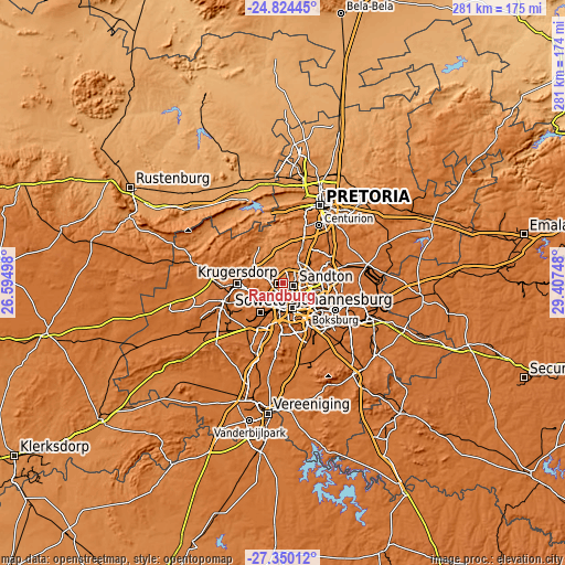
These maps also provides idea of topography and contour of this city, they are displayed at different zoom levels. More info about maps, scale and edge coordinates you can find below images.
| \ | Map #1 | Map #2 | Topo.Map |
| Scale [m] | 1420..1693 m | 1369..1808 m | × |
| Scale [ft] | 4659..5554 ft | 4491..5932 ft | × |
| Average | 1545.4 m = 5070 ft | 1562.6 m = 5127 ft | × |
| Width | 8.78 km = 5.5 mi | 17.55 km = 10.9 mi | 280.8 km = 174.5 mi |
| Height | 8.78 km = 5.5 mi | 17.55 km = 10.9 mi | 280.8 km = 174.5 mi |
| ↑Max Latitude | -26.054627° | -26.015141° | -24.82445° |
| Latitude at center | -26.0941° | -26.0941° | -26.0941° |
| ↓Min Latitude | -26.133559° | -26.173006° | -27.35012° |
| ← Min Longitude | 27.957285° | 27.913339° | 26.59498° |
| Longitude center | 28.00123° | 28.00123° | 28.00123° |
| →Max Longitude | 28.045175° | 28.089121° | 29.40748° |
Nearby cities:
Cities around Randburg sort by population:
• Johannesburg elevation 1767 m
12.8 km,  160°
160°
• Krugersdorp 1724 m
22.6 km,  272°
272°
• Diepsloot 1410 m
17.9 km,  3°
3°
• Roodepoort 1738 m
14.9 km,  239°
239°
• Midrand 1562 m
17.2 km,  47°
47°
• Edenvale 1651 m
16 km,  109°
109°
• Eden Glen 1620 m
17.2 km,  104°
104°
• Eastleigh 1594 m
15.9 km, 104°
• Eden Glen Ext 60 1636 m
16.7 km, 102°
• Modderfontein 1625 m
16.4 km,  88°
88°
• Muldersdriseloop 1441 m
17.5 km,  291°
291°
• Riverlea 1690 m
13.4 km,  192°
192°
Multilingual:
 En español:
Randburg elevación 1593 m.
 En France:
Randburg élévation 1593 m.
 Auf Deutsch:
Randburg höhe über dem Meeresspiegel ist 1593 m.

Sources and notes:
- [note 1] Map square and city borders are not equal. Map elevation data is calculated only from area inside that square.
- [src 1] Elevation data from geonames database provided with same terms of usage.
- [src 2] The elevation map of Randburg is generated using elevation data from NASA's 3 arcsec (90m) resolution SRTM data.
- [src 3] Base (background) map © OpenStreetMap contributors tiles are generated by Geofabrik and OpenTopoMap.
Copyright & License:
This Randburg Elevation Map is licensed under CC BY-SA. You may reuse any part from this page, if you give a proper credit by linking to this URL:
 More info on terms of use page.