Zastron elevation
Zastron (Orange Free State, Xhariep District Municipality), South Africa elevation is 1668 meters and Zastron elevation in feet is 5472 ft above sea level [src 1]. Zastron is a seat of a third-order administrative division (feature code) with elevation that is 696 meters (2283 ft) bigger than average city elevation in South Africa.
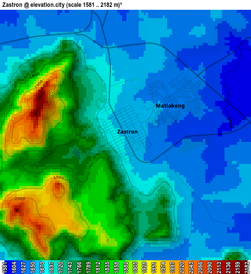
Below is the Elevation map of Zastron, which displays elevation range with different colors. Scale of the first map is from 1581 to 2182 m (5187 to 7159 ft) with average elevation of 1728.3 meters (=5670 ft) [note 1]
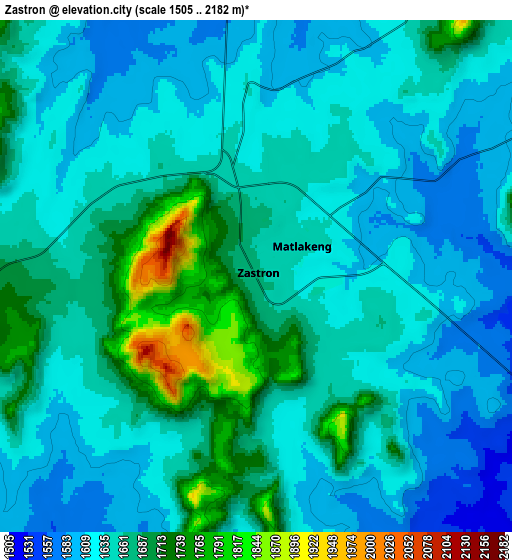
These maps also provides idea of topography and contour of this city, they are displayed at different zoom levels. More info about maps, scale and edge coordinates you can find below images.
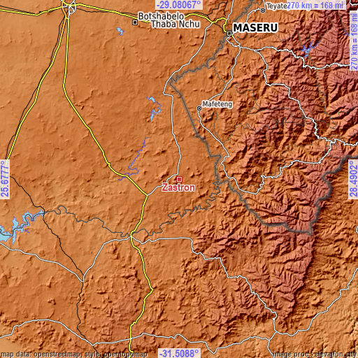
| \ | Map #1 | Map #2 | Topo.Map |
| Scale [m] | 1581..2182 m | 1505..2182 m | × |
| Scale [ft] | 5187..7159 ft | 4938..7159 ft | × |
| Average | 1728.3 m = 5670 ft | 1650.5 m = 5415 ft | × |
| Width | 8.44 km = 5.2 mi | 16.87 km = 10.5 mi | 270 km = 167.8 mi |
| Height | 8.44 km = 5.2 mi | 16.87 km = 10.5 mi | 270 km = 167.8 mi |
| ↑Max Latitude | -30.264301° | -30.226338° | -29.08067° |
| Latitude at center | -30.30225° | -30.30225° | -30.30225° |
| ↓Min Latitude | -30.340184° | -30.378103° | -31.5088° |
| ← Min Longitude | 27.040005° | 26.996059° | 25.6777° |
| Longitude center | 27.08395° | 27.08395° | 27.08395° |
| →Max Longitude | 27.127895° | 27.171841° | 28.4902° |
Nearby cities:
Cities around Zastron sort by population:
• Botshabelo elevation 1448 m
120.1 km,  343°
343°
• Aliwal North 1325 m
56.3 km,  219°
219°
• Thaba Nchu 1531 m
123.8 km,  348°
348°
• Ladybrand 1588 m
128.3 km,  16°
16°
• Burgersdorp 1405 m
105.8 km, 223°
• Elliot 1451 m
136 km,  147°
147°
• Molteno 1595 m
139.8 km,  209°
209°
• Dordrecht 1620 m
119 km,  181°
181°
• Trompsburg 1418 m
128.8 km,  283°
283°
• Dewetsdorp 1538 m
89.6 km,  333°
333°
• Barkly East 1789 m
88.8 km, 146°
• Lady Grey 1647 m
47.2 km,  164°
164°
Multilingual:
 En español:
Zastron elevación 1668 m.
 En France:
Zastron élévation 1668 m.
 Auf Deutsch:
Zastron höhe über dem Meeresspiegel ist 1668 m.

Sources and notes:
- [note 1] Map square and city borders are not equal. Map elevation data is calculated only from area inside that square.
- [src 1] Elevation data from geonames database provided with same terms of usage.
- [src 2] The elevation map of Zastron is generated using elevation data from NASA's 3 arcsec (90m) resolution SRTM data.
- [src 3] Base (background) map © OpenStreetMap contributors tiles are generated by Geofabrik and OpenTopoMap.
Copyright & License:
This Zastron Elevation Map is licensed under CC BY-SA. You may reuse any part from this page, if you give a proper credit by linking to this URL:
 More info on terms of use page.