Retreat elevation
Retreat (Western Cape, City of Cape Town), South Africa elevation is 8 meters and Retreat elevation in feet is 26 ft above sea level [src 1]. Retreat is a populated place (feature code) with elevation that is 964 meters (3163 ft) smaller than average city elevation in South Africa.
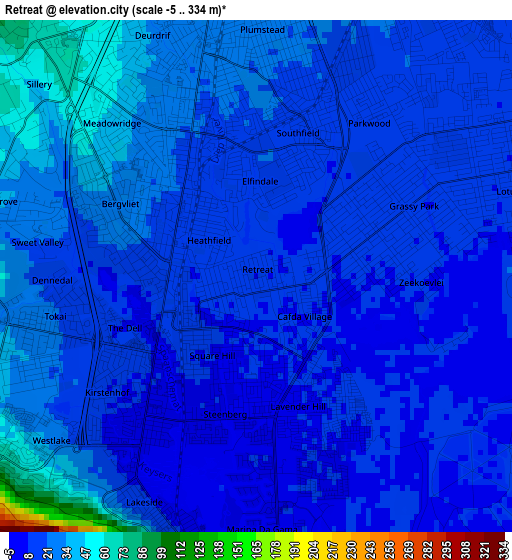
Below is the Elevation map of Retreat, which displays elevation range with different colors. Scale of the first map is from -5 to 334 m (-16 to 1096 ft) with average elevation of 19.8 meters (=65 ft) [note 1]
These maps also provides idea of topography and contour of this city, they are displayed at different zoom levels. More info about maps, scale and edge coordinates you can find below images.
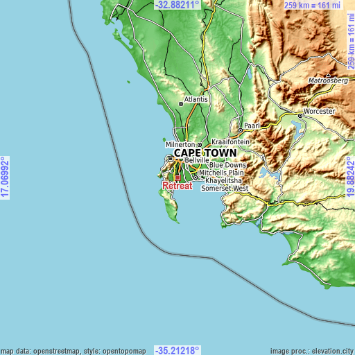
| \ | Map #1 | Map #2 | Topo.Map |
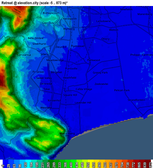
| Scale [m] | -5..334 m | -5..873 m | × |
| Scale [ft] | -16..1096 ft | -16..2864 ft | × |
| Average | 19.8 m = 65 ft | 104.4 m = 343 ft | × |
| Width | 8.1 km = 5 mi | 16.19 km = 10.1 mi | 259.1 km = 161 mi |
| Height | 8.1 km = 5 mi | 16.19 km = 10.1 mi | 259.1 km = 161 mi |
| ↑Max Latitude | -34.018734° | -33.982301° | -32.88211° |
| Latitude at center | -34.05515° | -34.05515° | -34.05515° |
| ↓Min Latitude | -34.091551° | -34.127936° | -35.21218° |
| ← Min Longitude | 18.432225° | 18.388279° | 17.06992° |
| Longitude center | 18.47617° | 18.47617° | 18.47617° |
| →Max Longitude | 18.520115° | 18.564061° | 19.88242° |
Nearby cities:
Cities around Retreat sort by population:
• Cape Town elevation 25 m
15.2 km,  341°
341°
• Stellenbosch 122 m
38.4 km,  69°
69°
• Kraaifontein 102 m
32 km,  43°
43°
• Grabouw 332 m
50.8 km,  102°
102°
• Lansdowne 22 m
7.8 km,  14°
14°
• Rondebosch 28 m
10.2 km,  0°
0°
• Claremont 38 m
8.4 km,  353°
353°
• Rosebank 11 m
11.1 km,  359°
359°
• Constantia 91 m
5.9 km,  296°
296°
• Newlands 70 m
8.9 km, 343°
• Bergvliet 27 m
2.3 km,  291°
291°
• Sunset Beach 7 m
22.4 km, 3°
Multilingual:
 En español:
Retreat elevación 8 m.
 En France:
Retreat élévation 8 m.


Sources and notes:
- [note 1] Map square and city borders are not equal. Map elevation data is calculated only from area inside that square.
- [src 1] Elevation data from geonames database provided with same terms of usage.
- [src 2] The elevation map of Retreat is generated using elevation data from NASA's 3 arcsec (90m) resolution SRTM data.
- [src 3] Base (background) map © OpenStreetMap contributors tiles are generated by Geofabrik and OpenTopoMap.
Copyright & License:
This Retreat Elevation Map is licensed under CC BY-SA. You may reuse any part from this page, if you give a proper credit by linking to this URL:
 More info on terms of use page.