Claremont elevation
Claremont (Western Cape, City of Cape Town), South Africa elevation is 38 meters and Claremont elevation in feet is 125 ft above sea level [src 1]. Claremont is a populated place (feature code) with elevation that is 934 meters (3064 ft) smaller than average city elevation in South Africa.
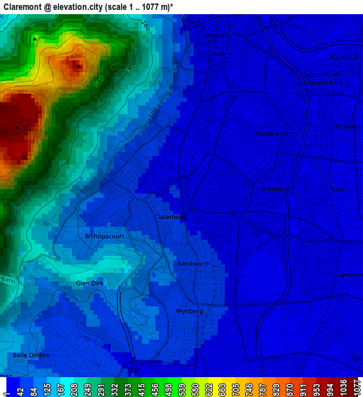
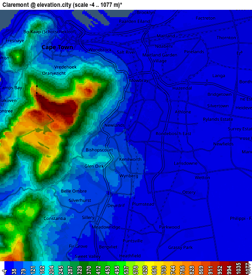
Below is the Elevation map of Claremont, which displays elevation range with different colors. Scale of the first map is from 1 to 1077 m (3 to 3533 ft) with average elevation of 130.1 meters (=427 ft) [note 1]
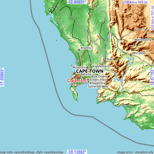
These maps also provides idea of topography and contour of this city, they are displayed at different zoom levels. More info about maps, scale and edge coordinates you can find below images.
| \ | Map #1 | Map #2 | Topo.Map |
| Scale [m] | 1..1077 m | -4..1077 m | × |
| Scale [ft] | 3..3533 ft | -13..3533 ft | × |
| Average | 130.1 m = 427 ft | 130.1 m = 427 ft | × |
| Width | 8.1 km = 5 mi | 16.21 km = 10.1 mi | 259.3 km = 161.1 mi |
| Height | 8.1 km = 5 mi | 16.21 km = 10.1 mi | 259.3 km = 161.1 mi |
| ↑Max Latitude | -33.944112° | -33.907647° | -32.80651° |
| Latitude at center | -33.98056° | -33.98056° | -33.98056° |
| ↓Min Latitude | -34.016993° | -34.05341° | -35.13862° |
| ← Min Longitude | 18.421335° | 18.377389° | 17.05903° |
| Longitude center | 18.46528° | 18.46528° | 18.46528° |
| →Max Longitude | 18.509225° | 18.553171° | 19.87153° |
Nearby cities:
Cities around Claremont sort by population:
• Cape Town elevation 25 m
7.2 km,  327°
327°
• Stellenbosch 122 m
37.4 km,  82°
82°
• Atlantis 178 m
46 km,  2°
2°
• Kraaifontein 102 m
27.5 km,  57°
57°
• Retreat 8 m
8.4 km,  173°
173°
• Lansdowne 22 m
3.1 km,  104°
104°
• Rondebosch 28 m
2.2 km,  28°
28°
• Rosebank 11 m
2.9 km,  16°
16°
• Constantia 91 m
7.1 km,  217°
217°
• Newlands 70 m
1.6 km,  278°
278°
• Bergvliet 27 m
7.5 km,  188°
188°
• Sunset Beach 7 m
14.3 km,  10°
10°
Multilingual:
 En español:
Claremont elevación 38 m.
 En France:
Claremont élévation 38 m.
 Auf Deutsch:
Claremont höhe über dem Meeresspiegel ist 38 m.

Sources and notes:
- [note 1] Map square and city borders are not equal. Map elevation data is calculated only from area inside that square.
- [src 1] Elevation data from geonames database provided with same terms of usage.
- [src 2] The elevation map of Claremont is generated using elevation data from NASA's 3 arcsec (90m) resolution SRTM data.
- [src 3] Base (background) map © OpenStreetMap contributors tiles are generated by Geofabrik and OpenTopoMap.
Copyright & License:
This Claremont Elevation Map is licensed under CC BY-SA. You may reuse any part from this page, if you give a proper credit by linking to this URL:
 More info on terms of use page.