Chiconi elevation
Chiconi, Mayotte elevation is 109 meters and Chiconi elevation in feet is 358 ft above sea level [src 1]. Chiconi is a seat of a first-order administrative division (feature code) with elevation that is 65 meters (213 ft) bigger than average city elevation in Mayotte.
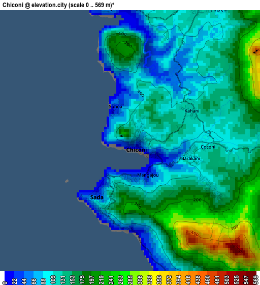
Below is the Elevation map of Chiconi, which displays elevation range with different colors. Scale of the first map is from 0 to 569 m (0 to 1867 ft) with average elevation of 150 meters (=492 ft) [note 1]
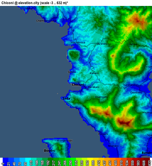
These maps also provides idea of topography and contour of this city, they are displayed at different zoom levels. More info about maps, scale and edge coordinates you can find below images.
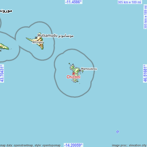
| \ | Map #1 | Map #2 | Topo.Map |
| Scale [m] | 0..569 m | -3..632 m | × |
| Scale [ft] | 0..1867 ft | -10..2073 ft | × |
| Average | 150 m = 492 ft | 159.3 m = 523 ft | × |
| Width | 9.53 km = 5.9 mi | 19.06 km = 11.8 mi | 304.9 km = 189.5 mi |
| Height | 9.53 km = 5.9 mi | 19.06 km = 11.8 mi | 304.9 km = 189.5 mi |
| ↑Max Latitude | -12.790479° | -12.74762° | -11.4586° |
| Latitude at center | -12.83333° | -12.83333° | -12.83333° |
| ↓Min Latitude | -12.876174° | -12.919011° | -14.20059° |
| ← Min Longitude | 45.066615° | 45.022669° | 43.70431° |
| Longitude center | 45.11056° | 45.11056° | 45.11056° |
| →Max Longitude | 45.154505° | 45.198451° | 46.51681° |
Nearby cities:
Cities around Chiconi sort by population:
• Mamoudzou elevation 23 m
14 km,  66°
66°
• Dembeni 15 m
8.1 km,  98°
98°
• Sada 82 m
2.1 km,  205°
205°
• Bandraboua 17 m
14.4 km,  5°
5°
• Tsingoni 56 m
5.2 km,  350°
350°
• Ouangani 100 m
3.1 km,  117°
117°
• Bandrélé 14 m
12.5 km,  134°
134°
• Chirongui 13 m
11.7 km,  159°
159°
• Bouéni 40 m
8.5 km, 205°
• M'Tsangamouji 57 m
8.7 km,  340°
340°
• Kani Kéli 95 m
13.4 km,  183°
183°
• Acoua 10 m
13.4 km,  334°
334°
Multilingual:
 En español:
Chiconi elevación 109 m.
 En France:
Chiconi élévation 109 m.


Sources and notes:
- [note 1] Map square and city borders are not equal. Map elevation data is calculated only from area inside that square.
- [src 1] Elevation data from geonames database provided with same terms of usage.
- [src 2] The elevation map of Chiconi is generated using elevation data from NASA's 3 arcsec (90m) resolution SRTM data.
- [src 3] Base (background) map © OpenStreetMap contributors tiles are generated by Geofabrik and OpenTopoMap.
Copyright & License:
This Chiconi Elevation Map is licensed under CC BY-SA. You may reuse any part from this page, if you give a proper credit by linking to this URL:
 More info on terms of use page.