Sūq Şirwāḩ elevation
Sūq Şirwāḩ (Ma’rib, Sirwah), Yemen elevation is 1480 meters and Sūq Şirwāḩ elevation in feet is 4856 ft above sea level [src 1]. Sūq Şirwāḩ is a seat of a second-order administrative division (feature code) with elevation that is 168 meters (551 ft) bigger than average city elevation in Yemen.
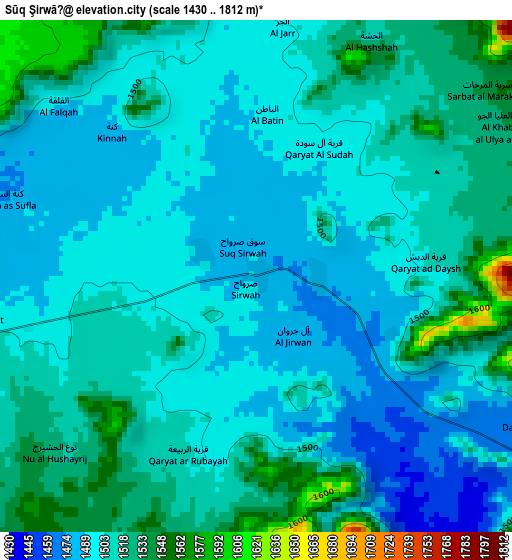
Below is the Elevation map of Sūq Şirwāḩ, which displays elevation range with different colors. Scale of the first map is from 1430 to 1812 m (4692 to 5945 ft) with average elevation of 1506.5 meters (=4943 ft) [note 1]
These maps also provides idea of topography and contour of this city, they are displayed at different zoom levels. More info about maps, scale and edge coordinates you can find below images.
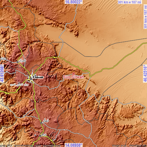
| \ | Map #1 | Topo.Map |
| Scale [m] | 1430..1812 m | × |
| Scale [ft] | 4692..5945 ft | × |
| Average | 1506.5 m = 4943 ft | × |
| Width | 9.42 km = 5.9 mi | 301.4 km = 187.3 mi |
| Height | 9.42 km = 5.9 mi | 301.4 km = 187.3 mi |
| ↑Max Latitude | 15.491683° | 16.80022° |
| Latitude at center | 15.44933° | 15.44933° |
| ↓Min Latitude | 15.406968° | 14.08958° |
| ← Min Longitude | 44.974965° | 43.61266° |
| Longitude center | 45.01891° | 45.01891° |
| →Max Longitude | 45.062855° | 46.42516° |
Nearby cities:
Cities around Sūq Şirwāḩ sort by population:
• Ma'rib elevation 1095 m
32.9 km,  87°
87°
• Ar Rawḑ 1099 m
71.6 km,  341°
341°
• Jiḩānah 2249 m
62.6 km,  246°
246°
• Al Madīd 2091 m
62.3 km,  290°
290°
• Raḩabah 1483 m
61.7 km,  182°
182°
• Majzar 1206 m
51.6 km,  329°
329°
• Judaydah 1256 m
51.4 km,  144°
144°
• Al Ḩarjah 1708 m
38.1 km,  276°
276°
• Al Ḩuşūn 1076 m
37.4 km, 85°
• Asdās 1102 m
35.8 km,  10°
10°
• Bidbadah 2099 m
34.3 km,  265°
265°
• Madghil 1197 m
16.8 km, 7°
Multilingual:
 En español:
Sūq Şirwāḩ elevación 1480 m.
 En France:
Sūq Şirwāḩ élévation 1480 m.
 Auf Deutsch:
Sūq Şirwāḩ höhe über dem Meeresspiegel ist 1480 m.

Sources and notes:
- [note 1] Map square and city borders are not equal. Map elevation data is calculated only from area inside that square.
- [src 1] Elevation data from geonames database provided with same terms of usage.
- [src 2] The elevation map of Sūq Şirwāḩ is generated using elevation data from NASA's 3 arcsec (90m) resolution SRTM data.
- [src 3] Base (background) map © OpenStreetMap contributors tiles are generated by Geofabrik and OpenTopoMap.
Copyright & License:
This Sūq Şirwāḩ Elevation Map is licensed under CC BY-SA. You may reuse any part from this page, if you give a proper credit by linking to this URL:
 More info on terms of use page.