Raḩabah elevation
Raḩabah (Ma’rib, Rahabah), Yemen elevation is 1483 meters and Raḩabah elevation in feet is 4865 ft above sea level [src 1]. Raḩabah is a seat of a second-order administrative division (feature code) with elevation that is 171 meters (561 ft) bigger than average city elevation in Yemen.
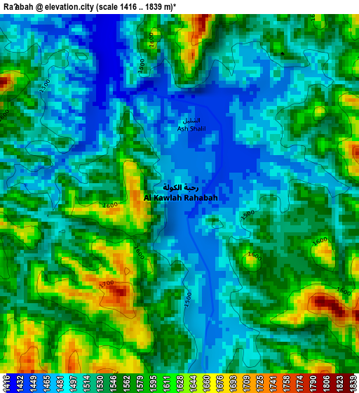
Below is the Elevation map of Raḩabah, which displays elevation range with different colors. Scale of the first map is from 1416 to 1839 m (4646 to 6033 ft) with average elevation of 1538.6 meters (=5048 ft) [note 1]
These maps also provides idea of topography and contour of this city, they are displayed at different zoom levels. More info about maps, scale and edge coordinates you can find below images.
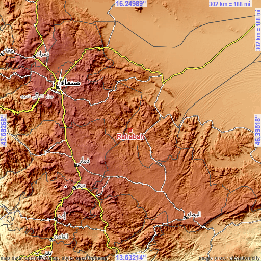
| \ | Map #1 | Topo.Map |
| Scale [m] | 1416..1839 m | × |
| Scale [ft] | 4646..6033 ft | × |
| Average | 1538.6 m = 5048 ft | × |
| Width | 9.44 km = 5.9 mi | 302.2 km = 187.8 mi |
| Height | 9.44 km = 5.9 mi | 302.2 km = 187.8 mi |
| ↑Max Latitude | 14.937764° | 16.24989° |
| Latitude at center | 14.8953° | 14.8953° |
| ↓Min Latitude | 14.852827° | 13.53214° |
| ← Min Longitude | 44.944985° | 43.58268° |
| Longitude center | 44.98893° | 44.98893° |
| →Max Longitude | 45.032875° | 46.39518° |
Nearby cities:
Cities around Raḩabah sort by population:
• Zarājah elevation 2380 m
65.7 km,  267°
267°
• An Najd 1996 m
62.2 km,  147°
147°
• Sūq Şirwāḩ 1480 m
61.7 km,  2°
2°
• Ash Sharyah 2010 m
60 km,  176°
176°
• Al Ḩajab 1203 m
58.2 km,  94°
94°
• Milāḩ 2177 m
57.6 km,  202°
202°
• Radā‘ 2125 m
55.8 km, 197°
• Ḩarīb 1161 m
55.4 km, 85°
• Al Aqţa‘ 2066 m
46.8 km,  123°
123°
• Al Qurayshīyah 2169 m
45 km, 198°
• Judaydah 1256 m
38.9 km,  59°
59°
• Al ‘Amūd 1661 m
30.4 km,  129°
129°
Multilingual:
 En español:
Raḩabah elevación 1483 m.
 En France:
Raḩabah élévation 1483 m.
 Auf Deutsch:
Raḩabah höhe über dem Meeresspiegel ist 1483 m.

Sources and notes:
- [note 1] Map square and city borders are not equal. Map elevation data is calculated only from area inside that square.
- [src 1] Elevation data from geonames database provided with same terms of usage.
- [src 2] The elevation map of Raḩabah is generated using elevation data from NASA's 3 arcsec (90m) resolution SRTM data.
- [src 3] Base (background) map © OpenStreetMap contributors tiles are generated by Geofabrik and OpenTopoMap.
Copyright & License:
This Raḩabah Elevation Map is licensed under CC BY-SA. You may reuse any part from this page, if you give a proper credit by linking to this URL:
 More info on terms of use page.