Maţarah elevation
Maţarah (Shabwah, Dhar), Yemen elevation is 838 meters and Maţarah elevation in feet is 2749 ft above sea level [src 1]. Maţarah is a seat of a second-order administrative division (feature code) with elevation that is 474 meters (1555 ft) smaller than average city elevation in Yemen.
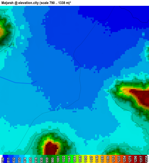
Below is the Elevation map of Maţarah, which displays elevation range with different colors. Scale of the first map is from 790 to 1338 m (2592 to 4390 ft) with average elevation of 872.1 meters (=2861 ft) [note 1]
These maps also provides idea of topography and contour of this city, they are displayed at different zoom levels. More info about maps, scale and edge coordinates you can find below images.
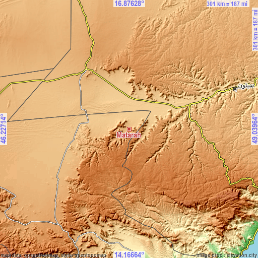
| \ | Map #1 | Topo.Map |
| Scale [m] | 790..1338 m | × |
| Scale [ft] | 2592..4390 ft | × |
| Average | 872.1 m = 2861 ft | × |
| Width | 9.42 km = 5.9 mi | 301.3 km = 187.2 mi |
| Height | 9.42 km = 5.9 mi | 301.3 km = 187.2 mi |
| ↑Max Latitude | 15.568247° | 16.87628° |
| Latitude at center | 15.52591° | 15.52591° |
| ↓Min Latitude | 15.483564° | 14.16664° |
| ← Min Longitude | 47.589445° | 46.22714° |
| Longitude center | 47.63339° | 47.63339° |
| →Max Longitude | 47.677335° | 49.03964° |
Nearby cities:
Cities around Maţarah sort by population:
• Al Shirūj elevation 1011 m
94.6 km,  171°
171°
• Jawl al Majma‘ 1092 m
92.6 km,  224°
224°
• Al Bāţinah 948 m
85.8 km,  93°
93°
• Al ‘Abr 942 m
80.2 km,  327°
327°
• Şīf 1009 m
78.3 km,  107°
107°
• Ḩajar al Mashā’ikh 1193 m
71.5 km,  17°
17°
• Az̧ Z̧alī‘ah 1398 m
70 km,  144°
144°
• Ḩurayḑah 838 m
59.4 km,  82°
82°
• Aţ Ţalḩ 1398 m
48.2 km,  211°
211°
• Al Māfūd 1054 m
45.7 km,  243°
243°
• ‘Amd 1270 m
45.1 km,  123°
123°
• Şanā’ 896 m
20 km,  134°
134°
Multilingual:
 En español:
Maţarah elevación 838 m.
 En France:
Maţarah élévation 838 m.


Sources and notes:
- [note 1] Map square and city borders are not equal. Map elevation data is calculated only from area inside that square.
- [src 1] Elevation data from geonames database provided with same terms of usage.
- [src 2] The elevation map of Maţarah is generated using elevation data from NASA's 3 arcsec (90m) resolution SRTM data.
- [src 3] Base (background) map © OpenStreetMap contributors tiles are generated by Geofabrik and OpenTopoMap.
Copyright & License:
This Maţarah Elevation Map is licensed under CC BY-SA. You may reuse any part from this page, if you give a proper credit by linking to this URL:
 More info on terms of use page.