Al Shirūj elevation
Al Shirūj (Ḩaḑramawt, Yabuth), Yemen elevation is 1011 meters and Al Shirūj elevation in feet is 3317 ft above sea level [src 1]. Al Shirūj is a seat of a second-order administrative division (feature code) with elevation that is 301 meters (988 ft) smaller than average city elevation in Yemen.
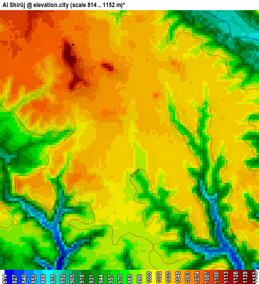
Below is the Elevation map of Al Shirūj, which displays elevation range with different colors. Scale of the first map is from 814 to 1152 m (2671 to 3780 ft) with average elevation of 1006.5 meters (=3302 ft) [note 1]
These maps also provides idea of topography and contour of this city, they are displayed at different zoom levels. More info about maps, scale and edge coordinates you can find below images.
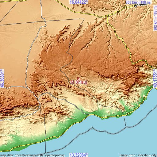
| \ | Map #1 | Topo.Map |
| Scale [m] | 814..1152 m | × |
| Scale [ft] | 2671..3780 ft | × |
| Average | 1006.5 m = 3302 ft | × |
| Width | 9.45 km = 5.9 mi | 302.5 km = 188 mi |
| Height | 9.45 km = 5.9 mi | 302.5 km = 188 mi |
| ↑Max Latitude | 14.727766° | 16.04122° |
| Latitude at center | 14.68526° | 14.68526° |
| ↓Min Latitude | 14.642746° | 13.32084° |
| ← Min Longitude | 47.725315° | 46.36301° |
| Longitude center | 47.76926° | 47.76926° |
| →Max Longitude | 47.813205° | 49.17551° |
Nearby cities:
Cities around Al Shirūj sort by population:
• Şīf elevation 1009 m
92.3 km,  40°
40°
• Al Māfūd 1054 m
91.8 km,  322°
322°
• Jawl al Majma‘ 1092 m
84.3 km,  289°
289°
• Ḩabbān 973 m
83.2 km,  243°
243°
• Şanā’ 896 m
79.5 km,  359°
359°
• ‘Amd 1270 m
72.1 km,  18°
18°
• Ruḑūm 166 m
66.8 km,  182°
182°
• Aţ Ţalḩ 1398 m
65.7 km, 322°
• Al Jawl 349 m
60.6 km,  114°
114°
• Ar Rawḑah 839 m
58.3 km,  245°
245°
• Mayfa‘ah 394 m
49.7 km,  203°
203°
• Az̧ Z̧alī‘ah 1398 m
45.4 km, 35°
Multilingual:
 En español:
Al Shirūj elevación 1011 m.
 En France:
Al Shirūj élévation 1011 m.
 Auf Deutsch:
Al Shirūj höhe über dem Meeresspiegel ist 1011 m.

Sources and notes:
- [note 1] Map square and city borders are not equal. Map elevation data is calculated only from area inside that square.
- [src 1] Elevation data from geonames database provided with same terms of usage.
- [src 2] The elevation map of Al Shirūj is generated using elevation data from NASA's 3 arcsec (90m) resolution SRTM data.
- [src 3] Base (background) map © OpenStreetMap contributors tiles are generated by Geofabrik and OpenTopoMap.
Copyright & License:
This Al Shirūj Elevation Map is licensed under CC BY-SA. You may reuse any part from this page, if you give a proper credit by linking to this URL:
 More info on terms of use page.