Al Ḩazm elevation
Al Ḩazm (Al Bayda, Na'man), Yemen elevation is 1259 meters and Al Ḩazm elevation in feet is 4131 ft above sea level [src 1]. Al Ḩazm is a seat of a second-order administrative division (feature code) with elevation that is 53 meters (174 ft) smaller than average city elevation in Yemen.
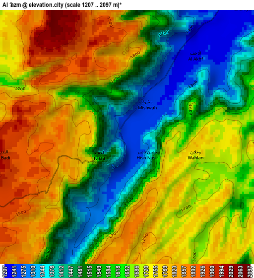
Below is the Elevation map of Al Ḩazm, which displays elevation range with different colors. Scale of the first map is from 1207 to 2097 m (3960 to 6880 ft) with average elevation of 1647.1 meters (=5404 ft) [note 1]
These maps also provides idea of topography and contour of this city, they are displayed at different zoom levels. More info about maps, scale and edge coordinates you can find below images.
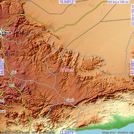
| \ | Map #1 | Topo.Map |
| Scale [m] | 1207..2097 m | × |
| Scale [ft] | 3960..6880 ft | × |
| Average | 1647.1 m = 5404 ft | × |
| Width | 9.45 km = 5.9 mi | 302.5 km = 188 mi |
| Height | 9.45 km = 5.9 mi | 302.5 km = 188 mi |
| ↑Max Latitude | 14.731695° | 16.04513° |
| Latitude at center | 14.68919° | 14.68919° |
| ↓Min Latitude | 14.646677° | 13.32479° |
| ← Min Longitude | 45.565675° | 44.20337° |
| Longitude center | 45.60962° | 45.60962° |
| →Max Longitude | 45.653565° | 47.01587° |
Nearby cities:
Cities around Al Ḩazm sort by population:
• Āl Ma‘ūdah elevation 2006 m
58.4 km,  204°
204°
• Judaydah 1256 m
54.3 km,  322°
322°
• An Najd 1996 m
45 km,  228°
228°
• ‘Usaylān 1036 m
44.8 km,  31°
31°
• Al ‘Amūd 1661 m
43.5 km,  274°
274°
• Maswarah 1926 m
40.4 km,  161°
161°
• Al ‘Āqir 1202 m
35.2 km,  112°
112°
• Ḩarīb 1161 m
29.3 km,  337°
337°
• Al Aqţa‘ 2066 m
28 km,  263°
263°
• Al Ḩajab 1203 m
20.1 km,  334°
334°
• Bayḩān 1127 m
17.1 km,  43°
43°
• Al Ghaylah 1754 m
10.8 km, 195°
Multilingual:
 En español:
Al Ḩazm elevación 1259 m.
 En France:
Al Ḩazm élévation 1259 m.
 Auf Deutsch:
Al Ḩazm höhe über dem Meeresspiegel ist 1259 m.

Sources and notes:
- [note 1] Map square and city borders are not equal. Map elevation data is calculated only from area inside that square.
- [src 1] Elevation data from geonames database provided with same terms of usage.
- [src 2] The elevation map of Al Ḩazm is generated using elevation data from NASA's 3 arcsec (90m) resolution SRTM data.
- [src 3] Base (background) map © OpenStreetMap contributors tiles are generated by Geofabrik and OpenTopoMap.
Copyright & License:
This Al Ḩazm Elevation Map is licensed under CC BY-SA. You may reuse any part from this page, if you give a proper credit by linking to this URL:
 More info on terms of use page.