‘Usaylān elevation
‘Usaylān (Shabwah, Usaylan), Yemen elevation is 1036 meters and ‘Usaylān elevation in feet is 3399 ft above sea level [src 1]. ‘Usaylān is a seat of a second-order administrative division (feature code) with elevation that is 276 meters (906 ft) smaller than average city elevation in Yemen.
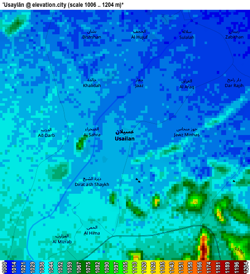
Below is the Elevation map of ‘Usaylān, which displays elevation range with different colors. Scale of the first map is from 1006 to 1204 m (3301 to 3950 ft) with average elevation of 1034.7 meters (=3395 ft) [note 1]
These maps also provides idea of topography and contour of this city, they are displayed at different zoom levels. More info about maps, scale and edge coordinates you can find below images.
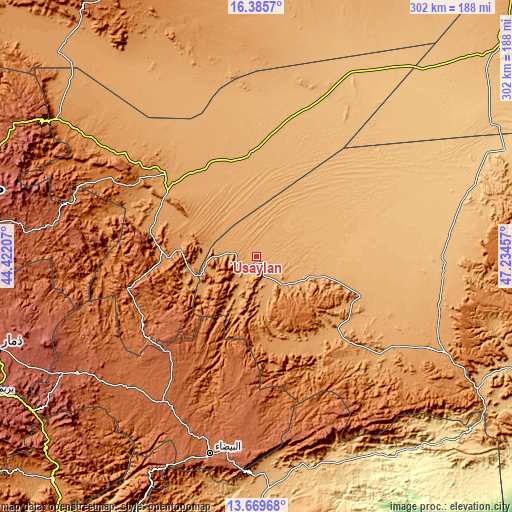
| \ | Map #1 | Topo.Map |
| Scale [m] | 1006..1204 m | × |
| Scale [ft] | 3301..3950 ft | × |
| Average | 1034.7 m = 3395 ft | × |
| Width | 9.44 km = 5.9 mi | 302 km = 187.7 mi |
| Height | 9.44 km = 5.9 mi | 302 km = 187.7 mi |
| ↑Max Latitude | 15.074447° | 16.3857° |
| Latitude at center | 15.03201° | 15.03201° |
| ↓Min Latitude | 14.989564° | 13.66968° |
| ← Min Longitude | 45.784375° | 44.42207° |
| Longitude center | 45.82832° | 45.82832° |
| →Max Longitude | 45.872265° | 47.23457° |
Nearby cities:
Cities around ‘Usaylān sort by population:
• Ma'rib elevation 1095 m
72.1 km,  311°
311°
• Khawrah 1199 m
75.4 km,  152°
152°
• Al ‘Amūd 1661 m
75.2 km,  242°
242°
• Al Ḩuşūn 1076 m
69.7 km, 314°
• Al Aqţa‘ 2066 m
65.7 km,  231°
231°
• Judaydah 1256 m
57 km,  274°
274°
• Al Ghaylah 1754 m
55.2 km,  208°
208°
• Al ‘Āqir 1202 m
52.3 km,  170°
170°
• Al Ḩazm 1259 m
44.8 km, 211°
• Al Ḩajab 1203 m
37.9 km, 238°
• Ḩarīb 1161 m
36.6 km,  252°
252°
• Bayḩān 1127 m
28.3 km,  204°
204°
Multilingual:
 En español:
‘Usaylān elevación 1036 m.
 En France:
‘Usaylān élévation 1036 m.
 Auf Deutsch:
‘Usaylān höhe über dem Meeresspiegel ist 1036 m.

Sources and notes:
- [note 1] Map square and city borders are not equal. Map elevation data is calculated only from area inside that square.
- [src 1] Elevation data from geonames database provided with same terms of usage.
- [src 2] The elevation map of ‘Usaylān is generated using elevation data from NASA's 3 arcsec (90m) resolution SRTM data.
- [src 3] Base (background) map © OpenStreetMap contributors tiles are generated by Geofabrik and OpenTopoMap.
Copyright & License:
This ‘Usaylān Elevation Map is licensed under CC BY-SA. You may reuse any part from this page, if you give a proper credit by linking to this URL:
 More info on terms of use page.