Ḩūth elevation
Ḩūth (Omran, Hooth), Yemen elevation is 1889 meters and Ḩūth elevation in feet is 6198 ft above sea level [src 1]. Ḩūth is a seat of a second-order administrative division (feature code) with elevation that is 577 meters (1893 ft) bigger than average city elevation in Yemen.
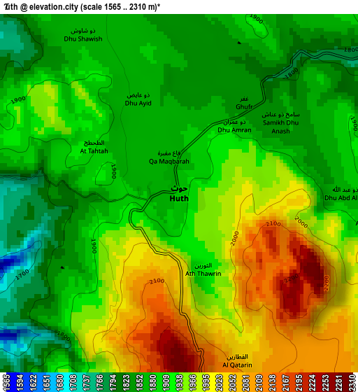
Below is the Elevation map of Ḩūth, which displays elevation range with different colors. Scale of the first map is from 1565 to 2310 m (5135 to 7579 ft) with average elevation of 1926 meters (=6319 ft) [note 1]
These maps also provides idea of topography and contour of this city, they are displayed at different zoom levels. More info about maps, scale and edge coordinates you can find below images.
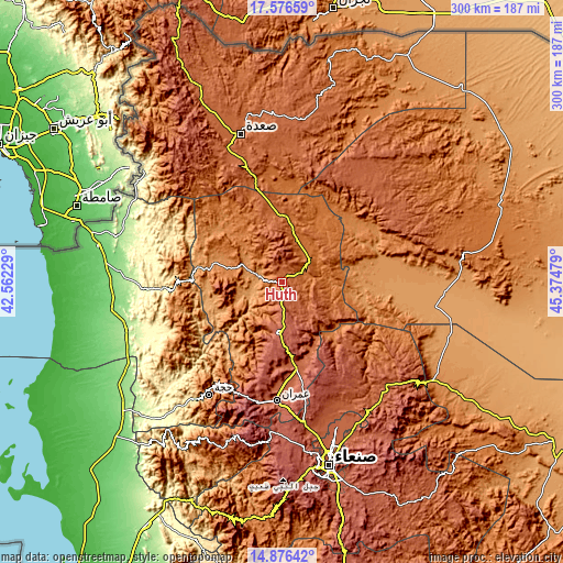
| \ | Map #1 | Topo.Map |
| Scale [m] | 1565..2310 m | × |
| Scale [ft] | 5135..7579 ft | × |
| Average | 1926 m = 6319 ft | × |
| Width | 9.38 km = 5.8 mi | 300.2 km = 186.5 mi |
| Height | 9.38 km = 5.8 mi | 300.3 km = 186.6 mi |
| ↑Max Latitude | 16.273329° | 17.57659° |
| Latitude at center | 16.23114° | 16.23114° |
| ↓Min Latitude | 16.188942° | 14.87642° |
| ← Min Longitude | 43.924595° | 42.56229° |
| Longitude center | 43.96854° | 43.96854° |
| →Max Longitude | 44.012485° | 45.37479° |
Nearby cities:
Cities around Ḩūth sort by population:
• Al Jamīmah elevation 1547 m
46.3 km,  239°
239°
• As Sūq al Jadīd 2190 m
46.3 km,  167°
167°
• Şuwayr 1269 m
38.7 km,  261°
261°
• As Sūdah 2035 m
36.3 km,  213°
213°
• Al Madān 2112 m
34.7 km,  268°
268°
• Ḩabūr 1764 m
34.4 km,  234°
234°
• Dhaybīn 1876 m
33 km,  148°
148°
• Shahārat al Ghīs 2518 m
28.9 km, 259°
• Khamir 2465 m
27.1 km,  183°
183°
• Al Qaflah 1305 m
23.5 km,  294°
294°
• Al Ḩarf 1570 m
19.9 km,  42°
42°
• Al ‘Ashshah 1197 m
12.5 km,  283°
283°
Multilingual:
 En español:
Ḩūth elevación 1889 m.
 En France:
Ḩūth élévation 1889 m.


Sources and notes:
- [note 1] Map square and city borders are not equal. Map elevation data is calculated only from area inside that square.
- [src 1] Elevation data from geonames database provided with same terms of usage.
- [src 2] The elevation map of Ḩūth is generated using elevation data from NASA's 3 arcsec (90m) resolution SRTM data.
- [src 3] Base (background) map © OpenStreetMap contributors tiles are generated by Geofabrik and OpenTopoMap.
Copyright & License:
This Ḩūth Elevation Map is licensed under CC BY-SA. You may reuse any part from this page, if you give a proper credit by linking to this URL:
 More info on terms of use page.