As Sūq al Jadīd elevation
As Sūq al Jadīd (Omran, Kharif), Yemen elevation is 2190 meters and As Sūq al Jadīd elevation in feet is 7185 ft above sea level [src 1]. As Sūq al Jadīd is a seat of a second-order administrative division (feature code) with elevation that is 878 meters (2881 ft) bigger than average city elevation in Yemen.
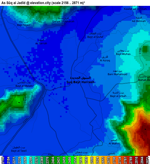
Below is the Elevation map of As Sūq al Jadīd, which displays elevation range with different colors. Scale of the first map is from 2156 to 2871 m (7073 to 9419 ft) with average elevation of 2245.8 meters (=7368 ft) [note 1]
These maps also provides idea of topography and contour of this city, they are displayed at different zoom levels. More info about maps, scale and edge coordinates you can find below images.
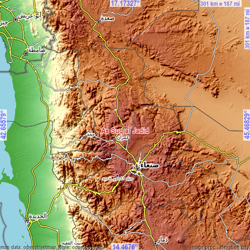
| \ | Map #1 | Topo.Map |
| Scale [m] | 2156..2871 m | × |
| Scale [ft] | 7073..9419 ft | × |
| Average | 2245.8 m = 7368 ft | × |
| Width | 9.4 km = 5.8 mi | 300.8 km = 186.9 mi |
| Height | 9.4 km = 5.8 mi | 300.9 km = 187 mi |
| ↑Max Latitude | 15.867235° | 17.17327° |
| Latitude at center | 15.82496° | 15.82496° |
| ↓Min Latitude | 15.782676° | 14.4676° |
| ← Min Longitude | 44.018095° | 42.65579° |
| Longitude center | 44.06204° | 44.06204° |
| →Max Longitude | 44.105985° | 45.46829° |
Nearby cities:
Cities around As Sūq al Jadīd sort by population:
• ‘Amrān elevation 2239 m
22.3 km,  214°
214°
• Al Khāniq 2191 m
38.1 km,  160°
160°
• Ḩabābah 2604 m
37.1 km, 212°
• As Sūdah 2035 m
33.5 km,  296°
296°
• An Nāşirah 2327 m
27.7 km,  257°
257°
• Saḩḩab 2605 m
25.1 km,  189°
189°
• Khamir 2465 m
21.5 km,  327°
327°
• Al Ḩayfah 2415 m
21.3 km,  118°
118°
• Bayt Marrān 2473 m
21.2 km,  133°
133°
• Aş Şarārah 2720 m
20.8 km, 260°
• Dhaybīn 1876 m
18.4 km,  22°
22°
• Raydah 2190 m
2.6 km,  242°
242°
Multilingual:
 En español:
As Sūq al Jadīd elevación 2190 m.
 En France:
As Sūq al Jadīd élévation 2190 m.
 Auf Deutsch:
As Sūq al Jadīd höhe über dem Meeresspiegel ist 2190 m.

Sources and notes:
- [note 1] Map square and city borders are not equal. Map elevation data is calculated only from area inside that square.
- [src 1] Elevation data from geonames database provided with same terms of usage.
- [src 2] The elevation map of As Sūq al Jadīd is generated using elevation data from NASA's 3 arcsec (90m) resolution SRTM data.
- [src 3] Base (background) map © OpenStreetMap contributors tiles are generated by Geofabrik and OpenTopoMap.
Copyright & License:
This As Sūq al Jadīd Elevation Map is licensed under CC BY-SA. You may reuse any part from this page, if you give a proper credit by linking to this URL:
 More info on terms of use page.