Kačanik elevation
Kačanik (Ferizaj, Komuna e Kaçanikut), Kosovo elevation is 487 meters and Kačanik elevation in feet is 1598 ft above sea level [src 1]. Kačanik is a seat of a second-order administrative division (feature code) with elevation that is 59 meters (194 ft) smaller than average city elevation in Kosovo.
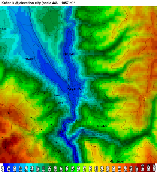
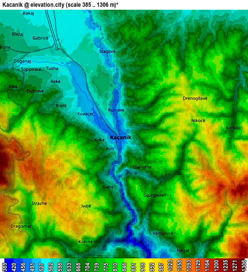
Below is the Elevation map of Kačanik, which displays elevation range with different colors. Scale of the first map is from 446 to 1057 m (1463 to 3468 ft) with average elevation of 703.9 meters (=2309 ft) [note 1]
These maps also provides idea of topography and contour of this city, they are displayed at different zoom levels. More info about maps, scale and edge coordinates you can find below images.
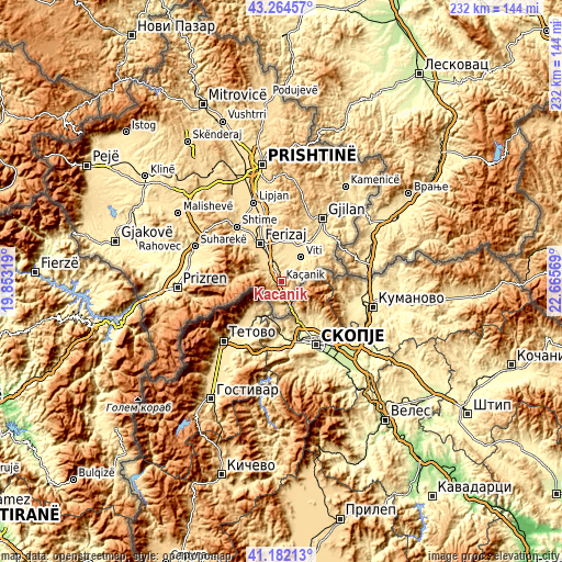
| \ | Map #1 | Map #2 | Topo.Map |
| Scale [m] | 446..1057 m | 385..1306 m | × |
| Scale [ft] | 1463..3468 ft | 1263..4285 ft | × |
| Average | 703.9 m = 2309 ft | 760.4 m = 2495 ft | × |
| Width | 7.24 km = 4.5 mi | 14.47 km = 9 mi | 231.5 km = 143.8 mi |
| Height | 7.24 km = 4.5 mi | 14.47 km = 9 mi | 231.5 km = 143.8 mi |
| ↑Max Latitude | 42.26447° | 42.296983° | 43.26457° |
| Latitude at center | 42.23194° | 42.23194° | 42.23194° |
| ↓Min Latitude | 42.199393° | 42.16683° | 41.18213° |
| ← Min Longitude | 21.215495° | 21.171549° | 19.85319° |
| Longitude center | 21.25944° | 21.25944° | 21.25944° |
| →Max Longitude | 21.303385° | 21.347331° | 22.66569° |
Nearby cities:
Cities around Kačanik sort by population:
• Suva Reka elevation 387 m
38.4 km,  291°
291°
• Ferizaj 582 m
17.6 km,  330°
330°
• Gjilan 513 m
30.7 km,  34°
34°
• Vitina 501 m
12.8 km,  39°
39°
• Shtime 572 m
28.7 km,  321°
321°
• Hani i Elezit 373 m
9.6 km,  161°
161°
• Lipljan 553 m
34 km,  341°
341°
• Štrpce 851 m
19.1 km,  272°
272°
• Klokot 491 m
18.2 km, 31°
• Partesh 493 m
23.7 km, 37°
• Budakovo 846 m
30.7 km,  296°
296°
• Gjinoc 425 m
37.5 km,  284°
284°
Multilingual:
 En español:
Kačanik elevación 487 m.
 En France:
Kačanik élévation 487 m.


Sources and notes:
- [note 1] Map square and city borders are not equal. Map elevation data is calculated only from area inside that square.
- [src 1] Elevation data from geonames database provided with same terms of usage.
- [src 2] The elevation map of Kačanik is generated using elevation data from NASA's 3 arcsec (90m) resolution SRTM data.
- [src 3] Base (background) map © OpenStreetMap contributors tiles are generated by Geofabrik and OpenTopoMap.
Copyright & License:
This Kačanik Elevation Map is licensed under CC BY-SA. You may reuse any part from this page, if you give a proper credit by linking to this URL:
 More info on terms of use page.