Shtime elevation
Shtime (Ferizaj, Komuna e Shtimes), Kosovo elevation is 572 meters and Shtime elevation in feet is 1877 ft above sea level [src 1]. Shtime is a seat of a second-order administrative division (feature code) with elevation that is 26 meters (85 ft) bigger than average city elevation in Kosovo.
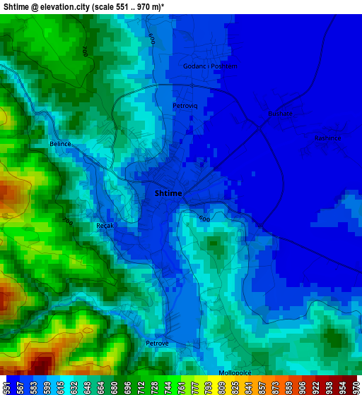
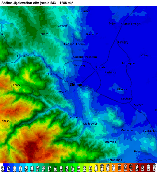
Below is the Elevation map of Shtime, which displays elevation range with different colors. Scale of the first map is from 551 to 970 m (1808 to 3182 ft) with average elevation of 629.3 meters (=2065 ft) [note 1]
These maps also provides idea of topography and contour of this city, they are displayed at different zoom levels. More info about maps, scale and edge coordinates you can find below images.
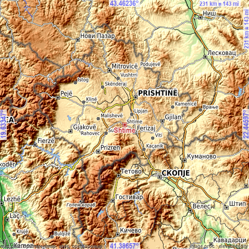
| \ | Map #1 | Map #2 | Topo.Map |
| Scale [m] | 551..970 m | 543..1288 m | × |
| Scale [ft] | 1808..3182 ft | 1781..4226 ft | × |
| Average | 629.3 m = 2065 ft | 705.5 m = 2315 ft | × |
| Width | 7.21 km = 4.5 mi | 14.43 km = 9 mi | 230.8 km = 143.4 mi |
| Height | 7.21 km = 4.5 mi | 14.43 km = 9 mi | 230.8 km = 143.4 mi |
| ↑Max Latitude | 42.465486° | 42.497896° | 43.46236° |
| Latitude at center | 42.43306° | 42.43306° | 42.43306° |
| ↓Min Latitude | 42.400617° | 42.368157° | 41.38657° |
| ← Min Longitude | 20.995775° | 20.951829° | 19.63347° |
| Longitude center | 21.03972° | 21.03972° | 21.03972° |
| →Max Longitude | 21.083665° | 21.127611° | 22.44597° |
Nearby cities:
Cities around Shtime sort by population:
• Suva Reka elevation 387 m
19.5 km,  244°
244°
• Ferizaj 582 m
11.8 km,  126°
126°
• Lipljan 553 m
12.1 km,  35°
35°
• Štrpce 851 m
21.6 km,  182°
182°
• Mališevo 529 m
24.7 km,  282°
282°
• Peqan 432 m
18.7 km,  252°
252°
• Budakovo 846 m
12.8 km,  227°
227°
• Leshan 370 m
24.3 km, 241°
• Gjinoc 425 m
22.2 km, 234°
• Pagaruša 539 m
24.5 km,  266°
266°
• Nishor 624 m
19.6 km, 267°
• Glanica 547 m
13.1 km,  8°
8°
Multilingual:
 En español:
Shtime elevación 572 m.
 En France:
Shtime élévation 572 m.


Sources and notes:
- [note 1] Map square and city borders are not equal. Map elevation data is calculated only from area inside that square.
- [src 1] Elevation data from geonames database provided with same terms of usage.
- [src 2] The elevation map of Shtime is generated using elevation data from NASA's 3 arcsec (90m) resolution SRTM data.
- [src 3] Base (background) map © OpenStreetMap contributors tiles are generated by Geofabrik and OpenTopoMap.
Copyright & License:
This Shtime Elevation Map is licensed under CC BY-SA. You may reuse any part from this page, if you give a proper credit by linking to this URL:
 More info on terms of use page.