Cam Ranh elevation
Cam Ranh (Khánh Hòa), Vietnam elevation is 15 meters and Cam Ranh elevation in feet is 49 ft above sea level [src 1]. Cam Ranh is a populated place (feature code) with elevation that is 113 meters (371 ft) smaller than average city elevation in Vietnam.
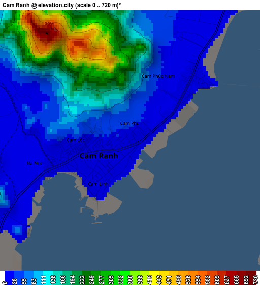
Below is the Elevation map of Cam Ranh, which displays elevation range with different colors. Scale of the first map is from 0 to 720 m (0 to 2362 ft) with average elevation of 117.1 meters (=384 ft) [note 1]
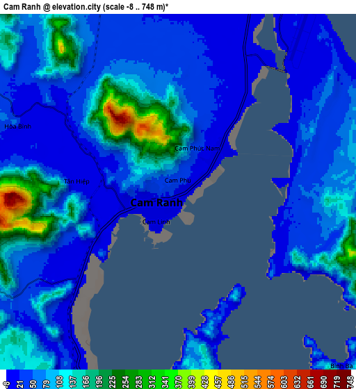
These maps also provides idea of topography and contour of this city, they are displayed at different zoom levels. More info about maps, scale and edge coordinates you can find below images.
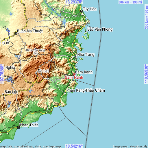
| \ | Map #1 | Map #2 | Topo.Map |
| Scale [m] | 0..720 m | -8..748 m | × |
| Scale [ft] | 0..2362 ft | -26..2454 ft | × |
| Average | 117.1 m = 384 ft | 78.7 m = 258 ft | × |
| Width | 9.56 km = 5.9 mi | 19.12 km = 11.9 mi | 305.9 km = 190.1 mi |
| Height | 9.56 km = 5.9 mi | 19.12 km = 11.9 mi | 306 km = 190.1 mi |
| ↑Max Latitude | 11.964434° | 12.007421° | 13.29375° |
| Latitude at center | 11.92144° | 11.92144° | 11.92144° |
| ↓Min Latitude | 11.878439° | 11.835431° | 10.54216° |
| ← Min Longitude | 109.115185° | 109.071239° | 107.75288° |
| Longitude center | 109.15913° | 109.15913° | 109.15913° |
| →Max Longitude | 109.203075° | 109.247021° | 110.56538° |
Nearby cities:
Cities around Cam Ranh sort by population:
• Nha Trang elevation 10 m
36.2 km,  6°
6°
• Phan Rang-Tháp Chàm 8 m
43.8 km,  205°
205°
• Thạnh Mỹ 1014 m
74.5 km,  256°
256°
• Ninh Hòa 7 m
63.5 km,  356°
356°
• Phước Dân 12 m
50.5 km, 209°
• Khánh Vĩnh 28 m
48.8 km,  325°
325°
• Tân Sơn 122 m
43.9 km,  248°
248°
• Khánh Hải 7 m
38.9 km,  199°
199°
• Diên Khánh 12 m
37.8 km,  349°
349°
• Bác Ái 136 m
29.3 km, 252°
• Tô Hạp 382 m
24.7 km,  292°
292°
• Cam Lâm 24 m
14.7 km,  0°
0°
Multilingual:
 En español:
Cam Ranh elevación 15 m.
 En France:
Cam Ranh élévation 15 m.


Sources and notes:
- [note 1] Map square and city borders are not equal. Map elevation data is calculated only from area inside that square.
- [src 1] Elevation data from geonames database provided with same terms of usage.
- [src 2] The elevation map of Cam Ranh is generated using elevation data from NASA's 3 arcsec (90m) resolution SRTM data.
- [src 3] Base (background) map © OpenStreetMap contributors tiles are generated by Geofabrik and OpenTopoMap.
Copyright & License:
This Cam Ranh Elevation Map is licensed under CC BY-SA. You may reuse any part from this page, if you give a proper credit by linking to this URL:
 More info on terms of use page.