Bình Long elevation
Bình Long (Bình Phước), Vietnam elevation is 126 meters and Bình Long elevation in feet is 413 ft above sea level [src 1]. Bình Long is a populated place (feature code) with elevation that is 2 meters (7 ft) smaller than average city elevation in Vietnam.
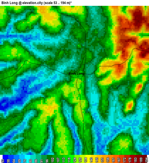
Below is the Elevation map of Bình Long, which displays elevation range with different colors. Scale of the first map is from 53 to 194 m (174 to 636 ft) with average elevation of 104.8 meters (=344 ft) [note 1]
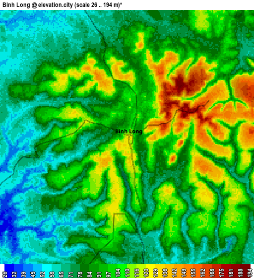
These maps also provides idea of topography and contour of this city, they are displayed at different zoom levels. More info about maps, scale and edge coordinates you can find below images.
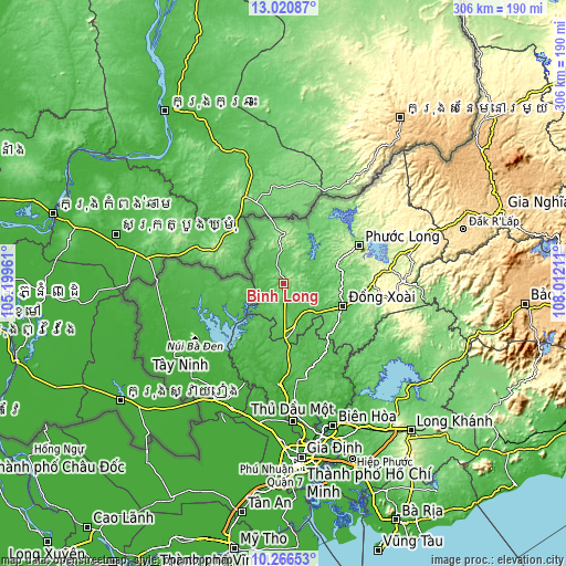
| \ | Map #1 | Map #2 | Topo.Map |
| Scale [m] | 53..194 m | 26..194 m | × |
| Scale [ft] | 174..636 ft | 85..636 ft | × |
| Average | 104.8 m = 344 ft | 90.3 m = 296 ft | × |
| Width | 9.57 km = 5.9 mi | 19.14 km = 11.9 mi | 306.3 km = 190.3 mi |
| Height | 9.57 km = 5.9 mi | 19.14 km = 11.9 mi | 306.3 km = 190.3 mi |
| ↑Max Latitude | 11.690147° | 11.733178° | 13.02087° |
| Latitude at center | 11.64711° | 11.64711° | 11.64711° |
| ↓Min Latitude | 11.604066° | 11.561016° | 10.26653° |
| ← Min Longitude | 106.561915° | 106.517969° | 105.19961° |
| Longitude center | 106.60586° | 106.60586° | 106.60586° |
| →Max Longitude | 106.649805° | 106.693751° | 108.01211° |
Nearby cities:
Cities around Bình Long sort by population:
• Phú Khương elevation 18 m
65.5 km,  231°
231°
• Don Luan 90 m
32.7 km,  112°
112°
• Tân Biên 18 m
65.7 km,  259°
259°
• Uyen Hung 39 m
65.7 km,  162°
162°
• Hòa Thành 12 m
65.6 km, 232°
• Dương Minh Châu 23 m
50.2 km, 234°
• Dầu Tiếng 21 m
49.4 km,  212°
212°
• Tân Châu 27 m
48.4 km, 257°
• Bù Đốp 113 m
40.2 km,  31°
31°
• Tân Phú 97 m
35.9 km,  127°
127°
• Chơn Thành 63 m
24.6 km,  172°
172°
• Lộc Ninh 112 m
22 km,  355°
355°
Multilingual:
 En español:
Bình Long elevación 126 m.
 En France:
Bình Long élévation 126 m.
 Auf Deutsch:
Bình Long höhe über dem Meeresspiegel ist 126 m.

Sources and notes:
- [note 1] Map square and city borders are not equal. Map elevation data is calculated only from area inside that square.
- [src 1] Elevation data from geonames database provided with same terms of usage.
- [src 2] The elevation map of Bình Long is generated using elevation data from NASA's 3 arcsec (90m) resolution SRTM data.
- [src 3] Base (background) map © OpenStreetMap contributors tiles are generated by Geofabrik and OpenTopoMap.
Copyright & License:
This Bình Long Elevation Map is licensed under CC BY-SA. You may reuse any part from this page, if you give a proper credit by linking to this URL:
 More info on terms of use page.