Phan Thiết elevation
Phan Thiết (Bình Thuận), Vietnam elevation is 10 meters and Phan Thiết elevation in feet is 33 ft above sea level [src 1]. Phan Thiết is a seat of a first-order administrative division (feature code) with elevation that is 118 meters (387 ft) smaller than average city elevation in Vietnam.
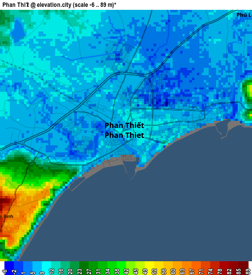
Below is the Elevation map of Phan Thiết, which displays elevation range with different colors. Scale of the first map is from -6 to 89 m (-20 to 292 ft) with average elevation of 11.1 meters (=36 ft) [note 1]
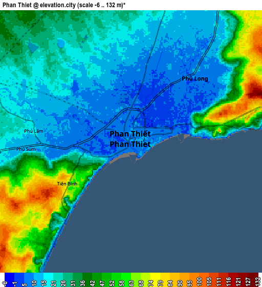
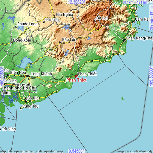
These maps also provides idea of topography and contour of this city, they are displayed at different zoom levels. More info about maps, scale and edge coordinates you can find below images.
| \ | Map #1 | Map #2 | Topo.Map |
| Scale [m] | -6..89 m | -6..132 m | × |
| Scale [ft] | -20..292 ft | -20..433 ft | × |
| Average | 11.1 m = 36 ft | 29.8 m = 98 ft | × |
| Width | 9.6 km = 6 mi | 19.19 km = 11.9 mi | 307 km = 190.8 mi |
| Height | 9.6 km = 6 mi | 19.19 km = 11.9 mi | 307 km = 190.8 mi |
| ↑Max Latitude | 10.972035° | 11.015174° | 12.30629° |
| Latitude at center | 10.92889° | 10.92889° | 10.92889° |
| ↓Min Latitude | 10.885739° | 10.842581° | 9.54506° |
| ← Min Longitude | 108.058135° | 108.014189° | 106.69583° |
| Longitude center | 108.10208° | 108.10208° | 108.10208° |
| →Max Longitude | 108.146025° | 108.189971° | 109.50833° |
Nearby cities:
Cities around Phan Thiết sort by population:
• La Gi elevation 8 m
46.8 km,  230°
230°
• Bảo Lộc 841 m
76 km,  334°
334°
• Tân Phú 136 m
82 km,  297°
297°
• Ma Đa Gui 160 m
80.1 km,  309°
309°
• Gia Ray 178 m
76.5 km,  269°
269°
• Liên Hương 16 m
75.5 km,  63°
63°
• Di Linh 978 m
72.6 km,  357°
357°
• Võ Xu 123 m
65.7 km, 295°
• Chợ Lầu 11 m
54.9 km,  53°
53°
• Tánh Linh 133 m
49.1 km,  290°
290°
• Thuận Nam 33 m
25.9 km,  250°
250°
• Ma Lâm 31 m
16.3 km,  10°
10°
Multilingual:
 En español:
Phan Thiết elevación 10 m.
 En France:
Phan Thiết élévation 10 m.
 Auf Deutsch:
Phan Thiết höhe über dem Meeresspiegel ist 10 m.

Sources and notes:
- [note 1] Map square and city borders are not equal. Map elevation data is calculated only from area inside that square.
- [src 1] Elevation data from geonames database provided with same terms of usage.
- [src 2] The elevation map of Phan Thiết is generated using elevation data from NASA's 3 arcsec (90m) resolution SRTM data.
- [src 3] Base (background) map © OpenStreetMap contributors tiles are generated by Geofabrik and OpenTopoMap.
Copyright & License:
This Phan Thiết Elevation Map is licensed under CC BY-SA. You may reuse any part from this page, if you give a proper credit by linking to this URL:
 More info on terms of use page.