Qui Nhon elevation
Qui Nhon (Bình Định, Phu Cat District), Vietnam elevation is 7 meters and Qui Nhon elevation in feet is 23 ft above sea level [src 1]. Qui Nhon is a seat of a first-order administrative division (feature code) with elevation that is 121 meters (397 ft) smaller than average city elevation in Vietnam.
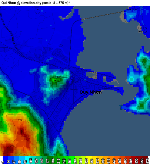
Below is the Elevation map of Qui Nhon, which displays elevation range with different colors. Scale of the first map is from -8 to 575 m (-26 to 1886 ft) with average elevation of 75.3 meters (=247 ft) [note 1]
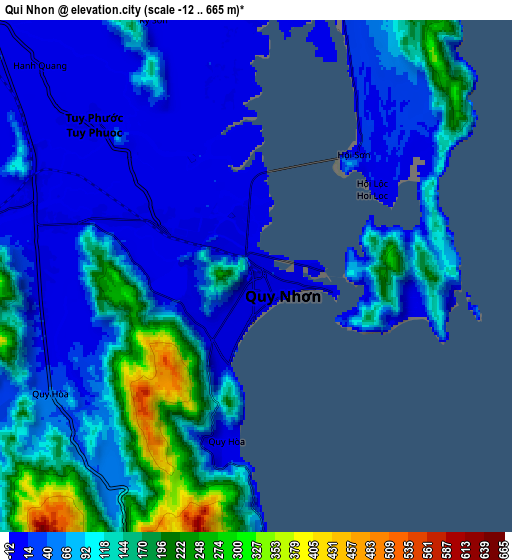
These maps also provides idea of topography and contour of this city, they are displayed at different zoom levels. More info about maps, scale and edge coordinates you can find below images.
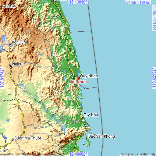
| \ | Map #1 | Map #2 | Topo.Map |
| Scale [m] | -8..575 m | -12..665 m | × |
| Scale [ft] | -26..1886 ft | -39..2182 ft | × |
| Average | 75.3 m = 247 ft | 84.9 m = 279 ft | × |
| Width | 9.49 km = 5.9 mi | 18.98 km = 11.8 mi | 303.7 km = 188.7 mi |
| Height | 9.49 km = 5.9 mi | 18.98 km = 11.8 mi | 303.7 km = 188.7 mi |
| ↑Max Latitude | 13.819157° | 13.861827° | 15.13816° |
| Latitude at center | 13.77648° | 13.77648° | 13.77648° |
| ↓Min Latitude | 13.733795° | 13.691102° | 12.40682° |
| ← Min Longitude | 109.179725° | 109.135779° | 107.81742° |
| Longitude center | 109.22367° | 109.22367° | 109.22367° |
| →Max Longitude | 109.267615° | 109.311561° | 110.62992° |
Nearby cities:
Cities around Qui Nhon sort by population:
• Sông Cầu elevation 10 m
35.7 km,  180°
180°
• Kông Chro 341 m
75.4 km,  269°
269°
• Hoài Ân 16 m
71 km,  336°
336°
• Vĩnh Thạnh 61 m
60.2 km,  307°
307°
• Chí Thạnh 14 m
52 km, 181°
• Phù Mỹ 29 m
47.8 km, 336°
• La Hai 13 m
46.1 km,  195°
195°
• Phú Phong 23 m
36.1 km,  294°
294°
• Phù Cát 22 m
30.9 km,  324°
324°
• Vân Canh 57 m
30 km,  234°
234°
• An Nhơn 13 m
17.4 km, 314°
• Tuy Phước 8 m
8.4 km, 312°
Multilingual:
 En español:
Qui Nhon elevación 7 m.
 En France:
Quy Nhơn élévation 7 m.


Sources and notes:
- [note 1] Map square and city borders are not equal. Map elevation data is calculated only from area inside that square.
- [src 1] Elevation data from geonames database provided with same terms of usage.
- [src 2] The elevation map of Qui Nhon is generated using elevation data from NASA's 3 arcsec (90m) resolution SRTM data.
- [src 3] Base (background) map © OpenStreetMap contributors tiles are generated by Geofabrik and OpenTopoMap.
Copyright & License:
This Qui Nhon Elevation Map is licensed under CC BY-SA. You may reuse any part from this page, if you give a proper credit by linking to this URL:
 More info on terms of use page.