Sông Cầu elevation
Sông Cầu (Phú Yên), Vietnam elevation is 10 meters and Sông Cầu elevation in feet is 33 ft above sea level [src 1]. Sông Cầu is a seat of a second-order administrative division (feature code) with elevation that is 118 meters (387 ft) smaller than average city elevation in Vietnam.
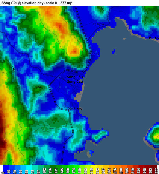
Below is the Elevation map of Sông Cầu, which displays elevation range with different colors. Scale of the first map is from 0 to 377 m (0 to 1237 ft) with average elevation of 93.7 meters (=307 ft) [note 1]
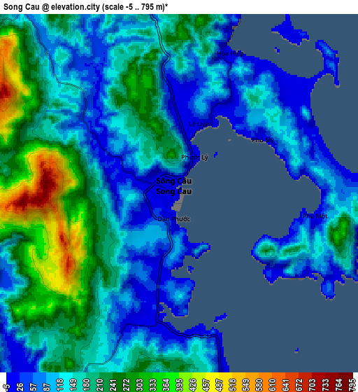
These maps also provides idea of topography and contour of this city, they are displayed at different zoom levels. More info about maps, scale and edge coordinates you can find below images.
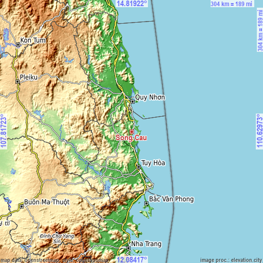
| \ | Map #1 | Map #2 | Topo.Map |
| Scale [m] | 0..377 m | -5..795 m | × |
| Scale [ft] | 0..1237 ft | -16..2608 ft | × |
| Average | 93.7 m = 307 ft | 167.6 m = 550 ft | × |
| Width | 9.5 km = 5.9 mi | 19.01 km = 11.8 mi | 304.1 km = 189 mi |
| Height | 9.5 km = 5.9 mi | 19.01 km = 11.8 mi | 304.1 km = 189 mi |
| ↑Max Latitude | 13.498335° | 13.541063° | 14.81922° |
| Latitude at center | 13.4556° | 13.4556° | 13.4556° |
| ↓Min Latitude | 13.412857° | 13.370107° | 12.08417° |
| ← Min Longitude | 109.179535° | 109.135589° | 107.81723° |
| Longitude center | 109.22348° | 109.22348° | 109.22348° |
| →Max Longitude | 109.267425° | 109.311371° | 110.62973° |
Nearby cities:
Cities around Sông Cầu sort by population:
• Qui Nhon elevation 7 m
35.7 km,  0°
0°
• Tuy Hòa 8 m
41.4 km,  165°
165°
• Phú Túc 135 m
64.5 km,  243°
243°
• Hai Riêng 207 m
63.7 km,  213°
213°
• Phù Cát 22 m
63.5 km,  343°
343°
• Phú Phong 23 m
60.3 km,  326°
326°
• Củng Sơn 55 m
52.3 km, 210°
• An Nhơn 13 m
49.4 km,  345°
345°
• Tuy Phước 8 m
41.8 km, 351°
• Vân Canh 57 m
30.4 km,  306°
306°
• Chí Thạnh 14 m
16.4 km,  183°
183°
• La Hai 13 m
15.2 km, 235°
Multilingual:
 En español:
Sông Cầu elevación 10 m.
 En France:
Sông Cầu élévation 10 m.


Sources and notes:
- [note 1] Map square and city borders are not equal. Map elevation data is calculated only from area inside that square.
- [src 1] Elevation data from geonames database provided with same terms of usage.
- [src 2] The elevation map of Sông Cầu is generated using elevation data from NASA's 3 arcsec (90m) resolution SRTM data.
- [src 3] Base (background) map © OpenStreetMap contributors tiles are generated by Geofabrik and OpenTopoMap.
Copyright & License:
This Sông Cầu Elevation Map is licensed under CC BY-SA. You may reuse any part from this page, if you give a proper credit by linking to this URL:
 More info on terms of use page.