Tam Đường elevation
Tam Đường (Lai Châu), Vietnam elevation is 643 meters and Tam Đường elevation in feet is 2110 ft above sea level [src 1]. Tam Đường is a seat of a second-order administrative division (feature code) with elevation that is 515 meters (1690 ft) bigger than average city elevation in Vietnam.
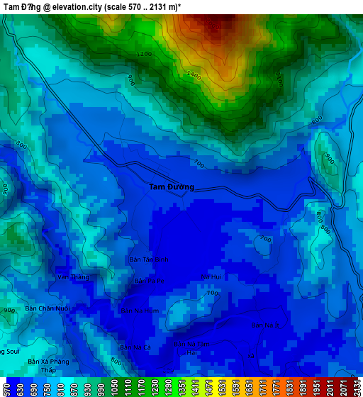
Below is the Elevation map of Tam Đường, which displays elevation range with different colors. Scale of the first map is from 570 to 2131 m (1870 to 6991 ft) with average elevation of 827.2 meters (=2714 ft) [note 1]
These maps also provides idea of topography and contour of this city, they are displayed at different zoom levels. More info about maps, scale and edge coordinates you can find below images.
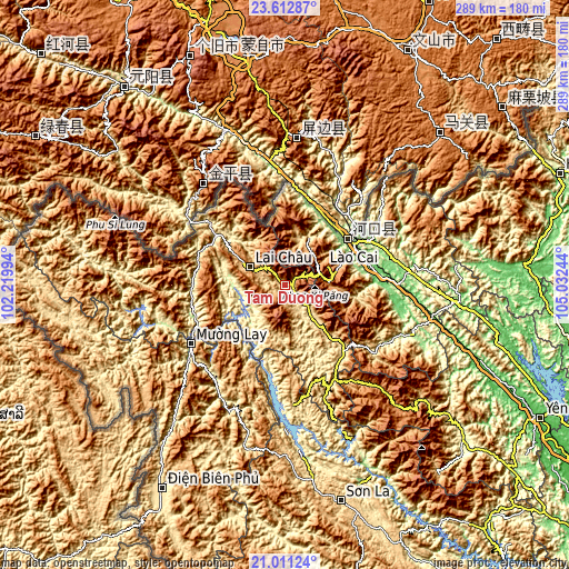
| \ | Map #1 | Topo.Map |
| Scale [m] | 570..2131 m | × |
| Scale [ft] | 1870..6991 ft | × |
| Average | 827.2 m = 2714 ft | × |
| Width | 9.04 km = 5.6 mi | 289.3 km = 179.8 mi |
| Height | 9.04 km = 5.6 mi | 289.3 km = 179.8 mi |
| ↑Max Latitude | 22.358767° | 23.61287° |
| Latitude at center | 22.31812° | 22.31812° |
| ↓Min Latitude | 22.277461° | 21.01124° |
| ← Min Longitude | 103.582245° | 102.21994° |
| Longitude center | 103.62619° | 103.62619° |
| →Max Longitude | 103.670135° | 105.03244° |
Nearby cities:
Cities around Tam Đường sort by population:
• Lào Cai elevation 86 m
40 km,  62°
62°
• Sa Pa 1522 m
22.6 km,  83°
83°
• Lao Chải 1168 m
24.9 km,  91°
91°
• Thị Trấn Khánh Yên 202 m
69.2 km,  111°
111°
• Thị Trấn Tủa Chùa 862 m
58.9 km,  209°
209°
• Thị Trấn Phố Lu 77 m
57.7 km, 89°
• Mường Chiên 160 m
53.3 km,  186°
186°
• Than Uyên 587 m
47.7 km,  146°
146°
• Phong Thổ 272 m
42.1 km,  306°
306°
• Thị Trấn Sìn Hồ 1592 m
40.7 km,  277°
277°
• Bát Xát 109 m
36.9 km,  47°
47°
• Lai Châu 919 m
19.3 km,  296°
296°
Multilingual:
 En español:
Tam Đường elevación 643 m.
 En France:
Tam Đường élévation 643 m.
 Auf Deutsch:
Tam Đường höhe über dem Meeresspiegel ist 643 m.

Sources and notes:
- [note 1] Map square and city borders are not equal. Map elevation data is calculated only from area inside that square.
- [src 1] Elevation data from geonames database provided with same terms of usage.
- [src 2] The elevation map of Tam Đường is generated using elevation data from NASA's 3 arcsec (90m) resolution SRTM data.
- [src 3] Base (background) map © OpenStreetMap contributors tiles are generated by Geofabrik and OpenTopoMap.
Copyright & License:
This Tam Đường Elevation Map is licensed under CC BY-SA. You may reuse any part from this page, if you give a proper credit by linking to this URL:
 More info on terms of use page.