La Fría elevation
La Fría (Táchira, Municipio García de Hevia), Venezuela elevation is 119 meters and La Fría elevation in feet is 390 ft above sea level [src 1]. La Fría is a seat of a second-order administrative division (feature code) with elevation that is 262 meters (860 ft) smaller than average city elevation in Venezuela.
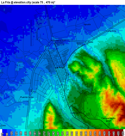
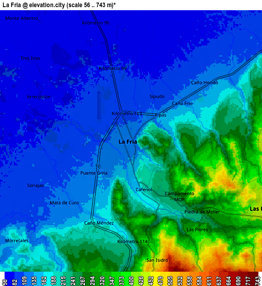
Below is the Elevation map of La Fría, which displays elevation range with different colors. Scale of the first map is from 75 to 470 m (246 to 1542 ft) with average elevation of 153 meters (=502 ft) [note 1]
These maps also provides idea of topography and contour of this city, they are displayed at different zoom levels. More info about maps, scale and edge coordinates you can find below images.
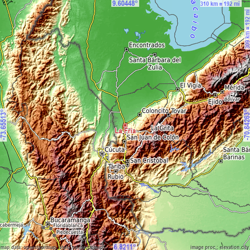
| \ | Map #1 | Map #2 | Topo.Map |
| Scale [m] | 75..470 m | 56..743 m | × |
| Scale [ft] | 246..1542 ft | 184..2438 ft | × |
| Average | 153 m = 502 ft | 177.9 m = 584 ft | × |
| Width | 9.67 km = 6 mi | 19.34 km = 12 mi | 309.5 km = 192.3 mi |
| Height | 9.67 km = 6 mi | 19.34 km = 12 mi | 309.5 km = 192.3 mi |
| ↑Max Latitude | 8.258722° | 8.302209° | 9.60448° |
| Latitude at center | 8.21523° | 8.21523° | 8.21523° |
| ↓Min Latitude | 8.171733° | 8.128232° | 6.8211° |
| ← Min Longitude | -72.292825° | -72.336771° | -73.65513° |
| Longitude center | -72.24888° | -72.24888° | -72.24888° |
| →Max Longitude | -72.204935° | -72.160989° | -70.84263° |
Nearby cities:
Cities around La Fría sort by population:
• Colón elevation 805 m
20.5 km,  183°
183°
• Cordero 1227 m
40.5 km,  169°
169°
• Ureña 345 m
39.5 km,  213°
213°
• Lobatera 960 m
31.7 km, 179°
• La Grita 1532 m
30.6 km,  107°
107°
• El Cobre 2108 m
29.1 km,  133°
133°
• Michelena 1248 m
28.8 km, 178°
• Santa Ana 1632 m
27.3 km, 113°
• Coloncito 164 m
21.6 km,  55°
55°
• Umuquena 557 m
21.1 km,  74°
74°
• Seboruco 880 m
20.8 km, 111°
• Las Mesas 484 m
11 km,  116°
116°
Multilingual:
 En español:
La Fría elevación 119 m.
 En France:
La Fría élévation 119 m.


Sources and notes:
- [note 1] Map square and city borders are not equal. Map elevation data is calculated only from area inside that square.
- [src 1] Elevation data from geonames database provided with same terms of usage.
- [src 2] The elevation map of La Fría is generated using elevation data from NASA's 3 arcsec (90m) resolution SRTM data.
- [src 3] Base (background) map © OpenStreetMap contributors tiles are generated by Geofabrik and OpenTopoMap.
Copyright & License:
This La Fría Elevation Map is licensed under CC BY-SA. You may reuse any part from this page, if you give a proper credit by linking to this URL:
 More info on terms of use page.