Canape Capatárida elevation
Canape Capatárida (Falcón, Municipio Buchivacoa), Venezuela elevation is 32 meters and Canape Capatárida elevation in feet is 105 ft above sea level [src 1]. Canape Capatárida is a seat of a second-order administrative division (feature code) with elevation that is 349 meters (1145 ft) smaller than average city elevation in Venezuela.
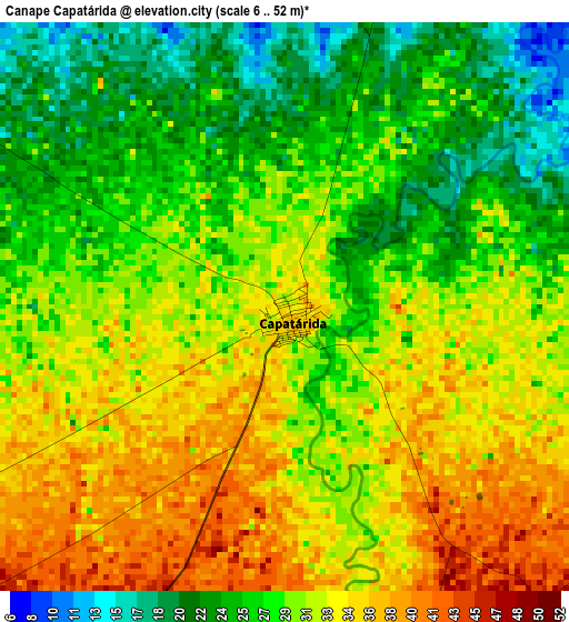
Below is the Elevation map of Canape Capatárida, which displays elevation range with different colors. Scale of the first map is from 6 to 52 m (20 to 171 ft) with average elevation of 29.8 meters (=98 ft) [note 1]
These maps also provides idea of topography and contour of this city, they are displayed at different zoom levels. More info about maps, scale and edge coordinates you can find below images.
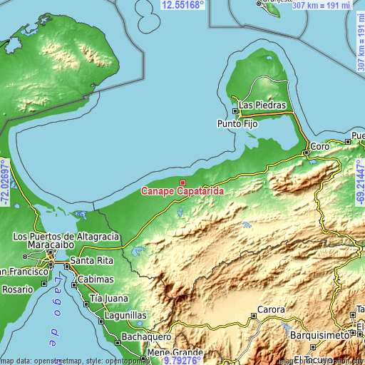
| \ | Map #1 | Topo.Map |
| Scale [m] | 6..52 m | × |
| Scale [ft] | 20..171 ft | × |
| Average | 29.8 m = 98 ft | × |
| Width | 9.59 km = 6 mi | 306.8 km = 190.6 mi |
| Height | 9.59 km = 6 mi | 306.8 km = 190.6 mi |
| ↑Max Latitude | 11.218609° | 12.55168° |
| Latitude at center | 11.1755° | 11.1755° |
| ↓Min Latitude | 11.132385° | 9.79276° |
| ← Min Longitude | -70.664665° | -72.02697° |
| Longitude center | -70.62072° | -70.62072° |
| →Max Longitude | -70.576775° | -69.21447° |
Nearby cities:
Cities around Canape Capatárida sort by population:
• Coro elevation 27 m
106.4 km,  76°
76°
• Punto Fijo 5 m
73.5 km,  38°
38°
• Punta Cardón 34 m
69.5 km, 39°
• Los Puertos de Altagracia 17 m
110.9 km,  242°
242°
• Cabure 630 m
110.1 km,  91°
91°
• San Luis 744 m
102.4 km, 93°
• La Cruz de Taratara 304 m
99.8 km,  97°
97°
• Santa Cruz de los Taques 10 m
82.3 km,  28°
28°
• Mene de Mauroa 131 m
71.3 km,  219°
219°
• Pedregal 178 m
57.3 km,  107°
107°
• Urumaco 92 m
39.9 km, 85°
• Dabajuro 93 m
18.1 km,  200°
200°
Multilingual:
 En español:
Canape Capatárida elevación 32 m.
 En France:
Canape Capatárida élévation 32 m.
 Auf Deutsch:
Canape Capatárida höhe über dem Meeresspiegel ist 32 m.

Sources and notes:
- [note 1] Map square and city borders are not equal. Map elevation data is calculated only from area inside that square.
- [src 1] Elevation data from geonames database provided with same terms of usage.
- [src 2] The elevation map of Canape Capatárida is generated using elevation data from NASA's 3 arcsec (90m) resolution SRTM data.
- [src 3] Base (background) map © OpenStreetMap contributors tiles are generated by Geofabrik and OpenTopoMap.
Copyright & License:
This Canape Capatárida Elevation Map is licensed under CC BY-SA. You may reuse any part from this page, if you give a proper credit by linking to this URL:
 More info on terms of use page.