Chichiriviche elevation
Chichiriviche (Falcón, Municipio Monseñor Iturriza), Venezuela elevation is 8 meters and Chichiriviche elevation in feet is 26 ft above sea level [src 1]. Chichiriviche is a seat of a second-order administrative division (feature code) with elevation that is 373 meters (1224 ft) smaller than average city elevation in Venezuela.
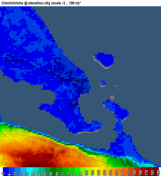
Below is the Elevation map of Chichiriviche, which displays elevation range with different colors. Scale of the first map is from -3 to 190 m (-10 to 623 ft) with average elevation of 43.6 meters (=143 ft) [note 1]
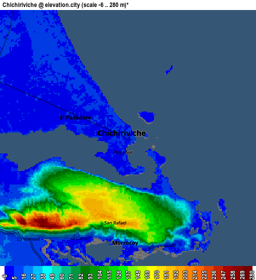
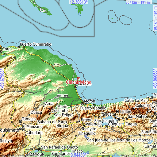
These maps also provides idea of topography and contour of this city, they are displayed at different zoom levels. More info about maps, scale and edge coordinates you can find below images.
| \ | Map #1 | Map #2 | Topo.Map |
| Scale [m] | -3..190 m | -6..280 m | × |
| Scale [ft] | -10..623 ft | -20..919 ft | × |
| Average | 43.6 m = 143 ft | 45.8 m = 150 ft | × |
| Width | 9.6 km = 6 mi | 19.19 km = 11.9 mi | 307 km = 190.8 mi |
| Height | 9.6 km = 6 mi | 19.19 km = 11.9 mi | 307 km = 190.8 mi |
| ↑Max Latitude | 10.971865° | 11.015004° | 12.30613° |
| Latitude at center | 10.92872° | 10.92872° | 10.92872° |
| ↓Min Latitude | 10.885569° | 10.842411° | 9.54489° |
| ← Min Longitude | -68.316775° | -68.360721° | -69.67908° |
| Longitude center | -68.27283° | -68.27283° | -68.27283° |
| →Max Longitude | -68.228885° | -68.184939° | -66.86658° |
Nearby cities:
Cities around Chichiriviche sort by population:
• Puerto Cabello elevation 49 m
58.1 km,  150°
150°
• Morón 19 m
49.7 km,  170°
170°
• Tucacas 3 m
16.5 km,  200°
200°
• Montalbán 669 m
79.8 km,  184°
184°
• Ocumare de la Costa 15 m
75.7 km,  133°
133°
• Jacura 285 m
65.7 km,  284°
284°
• Farriar 40 m
59.8 km,  211°
211°
• Yumare 64 m
57.2 km,  229°
229°
• Mirimire 166 m
55.8 km,  297°
297°
• Palmasola 38 m
47.6 km,  218°
218°
• San Juan de los Cayos 1 m
31.1 km,  330°
330°
• Yaracal 62 m
30.2 km, 278°
Multilingual:
 En español:
Chichiriviche elevación 8 m.
 En France:
Chichiriviche élévation 8 m.
 Auf Deutsch:
Chichiriviche höhe über dem Meeresspiegel ist 8 m.

Sources and notes:
- [note 1] Map square and city borders are not equal. Map elevation data is calculated only from area inside that square.
- [src 1] Elevation data from geonames database provided with same terms of usage.
- [src 2] The elevation map of Chichiriviche is generated using elevation data from NASA's 3 arcsec (90m) resolution SRTM data.
- [src 3] Base (background) map © OpenStreetMap contributors tiles are generated by Geofabrik and OpenTopoMap.
Copyright & License:
This Chichiriviche Elevation Map is licensed under CC BY-SA. You may reuse any part from this page, if you give a proper credit by linking to this URL:
 More info on terms of use page.