Güiria elevation
Güiria (Sucre, Municipio Valdez), Venezuela elevation is 10 meters and Güiria elevation in feet is 33 ft above sea level [src 1]. Güiria is a seat of a second-order administrative division (feature code) with elevation that is 371 meters (1217 ft) smaller than average city elevation in Venezuela.
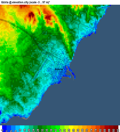
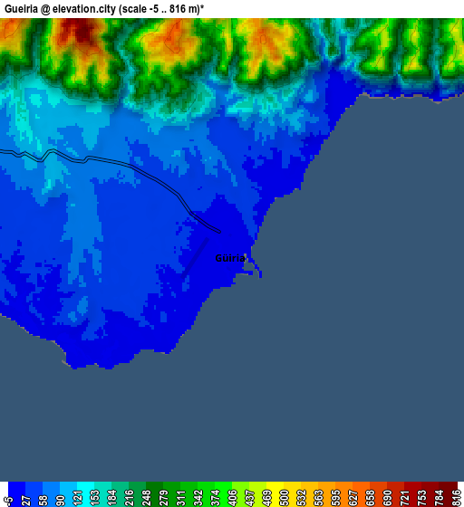
Below is the Elevation map of Güiria, which displays elevation range with different colors. Scale of the first map is from -3 to 97 m (-10 to 318 ft) with average elevation of 33.2 meters (=109 ft) [note 1]
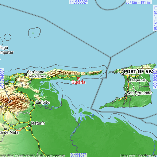
These maps also provides idea of topography and contour of this city, they are displayed at different zoom levels. More info about maps, scale and edge coordinates you can find below images.
| \ | Map #1 | Map #2 | Topo.Map |
| Scale [m] | -3..97 m | -5..816 m | × |
| Scale [ft] | -10..318 ft | -16..2677 ft | × |
| Average | 33.2 m = 109 ft | 144.4 m = 474 ft | × |
| Width | 9.61 km = 6 mi | 19.21 km = 11.9 mi | 307.4 km = 191 mi |
| Height | 9.61 km = 6 mi | 19.21 km = 11.9 mi | 307.4 km = 191 mi |
| ↑Max Latitude | 10.620406° | 10.663595° | 11.95632° |
| Latitude at center | 10.57721° | 10.57721° | 10.57721° |
| ↓Min Latitude | 10.534008° | 10.490801° | 9.19187° |
| ← Min Longitude | -62.342355° | -62.386301° | -63.70466° |
| Longitude center | -62.29841° | -62.29841° | -62.29841° |
| →Max Longitude | -62.254465° | -62.210519° | -60.89216° |
Nearby cities:
Cities around Güiria sort by population:
• Maturín elevation 71 m
133.9 km,  226°
226°
• Carúpano 15 m
104.9 km,  275°
275°
• Casanay 78 m
122.6 km,  266°
266°
• Quiriquire 73 m
120.8 km,  236°
236°
• San José de Aerocuar 185 m
112.6 km, 271°
• Caripito 43 m
101.8 km, 239°
• El Pilar 23 m
93.6 km, 267°
• Río Caribe 177 m
89.6 km, 278°
• Tunapuy 48 m
88.4 km, 269°
• Pedernales 13 m
67.6 km,  175°
175°
• Yaguaraparo 36 m
57.7 km, 269°
• Irapa 5 m
31 km, 268°
Multilingual:
 En español:
Güiria elevación 10 m.
 En France:
Güiria élévation 10 m.


Sources and notes:
- [note 1] Map square and city borders are not equal. Map elevation data is calculated only from area inside that square.
- [src 1] Elevation data from geonames database provided with same terms of usage.
- [src 2] The elevation map of Güiria is generated using elevation data from NASA's 3 arcsec (90m) resolution SRTM data.
- [src 3] Base (background) map © OpenStreetMap contributors tiles are generated by Geofabrik and OpenTopoMap.
Copyright & License:
This Güiria Elevation Map is licensed under CC BY-SA. You may reuse any part from this page, if you give a proper credit by linking to this URL:
 More info on terms of use page.