San Antonio del Golfo elevation
San Antonio del Golfo (Sucre, Municipio Mejía), Venezuela elevation is 39 meters and San Antonio del Golfo elevation in feet is 128 ft above sea level [src 1]. San Antonio del Golfo is a seat of a second-order administrative division (feature code) with elevation that is 342 meters (1122 ft) smaller than average city elevation in Venezuela.
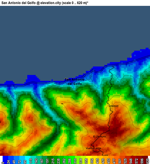
Below is the Elevation map of San Antonio del Golfo, which displays elevation range with different colors. Scale of the first map is from 0 to 620 m (0 to 2034 ft) with average elevation of 296.2 meters (=972 ft) [note 1]
These maps also provides idea of topography and contour of this city, they are displayed at different zoom levels. More info about maps, scale and edge coordinates you can find below images.
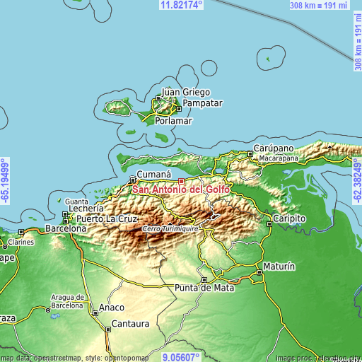
| \ | Map #1 | Topo.Map |
| Scale [m] | 0..620 m | × |
| Scale [ft] | 0..2034 ft | × |
| Average | 296.2 m = 972 ft | × |
| Width | 9.61 km = 6 mi | 307.5 km = 191.1 mi |
| Height | 9.61 km = 6 mi | 307.5 km = 191.1 mi |
| ↑Max Latitude | 10.485195° | 11.82174° |
| Latitude at center | 10.44198° | 10.44198° |
| ↓Min Latitude | 10.398759° | 9.05607° |
| ← Min Longitude | -63.832685° | -65.19499° |
| Longitude center | -63.78874° | -63.78874° |
| →Max Longitude | -63.744795° | -62.38249° |
Nearby cities:
Cities around San Antonio del Golfo sort by population:
• Cumaná elevation 4 m
43.1 km,  271°
271°
• Porlamar 22 m
58 km,  351°
351°
• El Valle del Espíritu Santo 61 m
61.1 km, 350°
• Araya 40 m
53.3 km,  286°
286°
• San José de Aerocuar 185 m
53.3 km,  70°
70°
• San Pedro de Coche 2 m
44 km,  328°
328°
• Caripe 943 m
43.4 km,  133°
133°
• Casanay 78 m
41.2 km,  80°
80°
• San Antonio 474 m
36.6 km,  169°
169°
• Cariaco 30 m
26.5 km, 76°
• Cumanacoa 230 m
25.6 km,  213°
213°
• Marigüitar 14 m
12.4 km, 273°
Multilingual:
 En español:
San Antonio del Golfo elevación 39 m.
 En France:
San Antonio del Golfo élévation 39 m.
 Auf Deutsch:
San Antonio del Golfo höhe über dem Meeresspiegel ist 39 m.
 На русском:
San Antonio del Golfo высота над уровнем моря 39 м
Sources and notes:
- [note 1] Map square and city borders are not equal. Map elevation data is calculated only from area inside that square.
- [src 1] Elevation data from geonames database provided with same terms of usage.
- [src 2] The elevation map of San Antonio del Golfo is generated using elevation data from NASA's 3 arcsec (90m) resolution SRTM data.
- [src 3] Base (background) map © OpenStreetMap contributors tiles are generated by Geofabrik and OpenTopoMap.
Copyright & License:
This San Antonio del Golfo Elevation Map is licensed under CC BY-SA. You may reuse any part from this page, if you give a proper credit by linking to this URL:
 More info on terms of use page.