Bo‘ka elevation
Bo‘ka (Toshkent), Uzbekistan elevation is 341 meters and Bo‘ka elevation in feet is 1119 ft above sea level [src 1]. Bo‘ka is a populated place (feature code) with elevation that is 88 meters (289 ft) smaller than average city elevation in Uzbekistan.
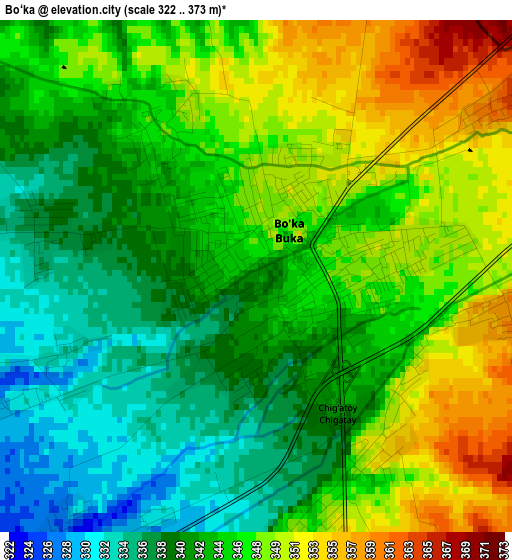
Below is the Elevation map of Bo‘ka, which displays elevation range with different colors. Scale of the first map is from 322 to 373 m (1056 to 1224 ft) with average elevation of 344.1 meters (=1129 ft) [note 1]
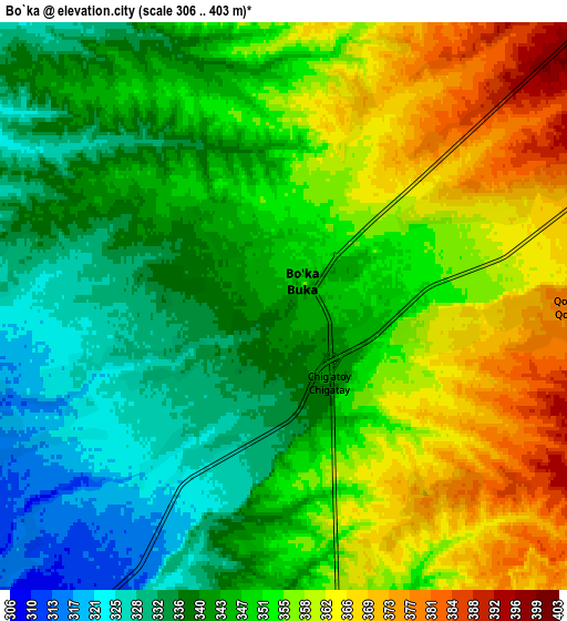
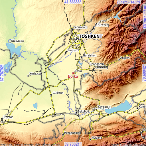
These maps also provides idea of topography and contour of this city, they are displayed at different zoom levels. More info about maps, scale and edge coordinates you can find below images.
| \ | Map #1 | Map #2 | Topo.Map |
| Scale [m] | 322..373 m | 306..403 m | × |
| Scale [ft] | 1056..1224 ft | 1004..1322 ft | × |
| Average | 344.1 m = 1129 ft | 348.8 m = 1144 ft | × |
| Width | 7.4 km = 4.6 mi | 14.79 km = 9.2 mi | 236.7 km = 147.1 mi |
| Height | 7.4 km = 4.6 mi | 14.79 km = 9.2 mi | 236.7 km = 147.1 mi |
| ↑Max Latitude | 40.844332° | 40.877568° | 41.86688° |
| Latitude at center | 40.81108° | 40.81108° | 40.81108° |
| ↓Min Latitude | 40.777811° | 40.744525° | 39.73821° |
| ← Min Longitude | 69.150225° | 69.106279° | 67.78792° |
| Longitude center | 69.19417° | 69.19417° | 69.19417° |
| →Max Longitude | 69.238115° | 69.282061° | 70.60042° |
Nearby cities:
Cities around Bo‘ka sort by population:
• Olmaliq elevation 569 m
34.2 km,  83°
83°
• Yangiyŭl 347 m
35.7 km,  339°
339°
• Guliston 273 m
49.7 km,  224°
224°
• Ohangaron 567 m
38.8 km,  74°
74°
• Piskent 416 m
16.3 km,  53°
53°
• Sirdaryo 263 m
44.9 km,  274°
274°
• Bektemir 420 m
45.9 km,  14°
14°
• Zafar 307 m
31.3 km,  307°
307°
• Chinoz 275 m
39 km,  290°
290°
• Tŭytepa 395 m
28.4 km,  29°
29°
• Ŭrtaowul 386 m
42 km,  354°
354°
• Amir Timur 319 m
31.5 km,  317°
317°
Multilingual:
 En español:
Bo‘ka elevación 341 m.
 En France:
Bo‘ka élévation 341 m.


Sources and notes:
- [note 1] Map square and city borders are not equal. Map elevation data is calculated only from area inside that square.
- [src 1] Elevation data from geonames database provided with same terms of usage.
- [src 2] The elevation map of Bo‘ka is generated using elevation data from NASA's 3 arcsec (90m) resolution SRTM data.
- [src 3] Base (background) map © OpenStreetMap contributors tiles are generated by Geofabrik and OpenTopoMap.
Copyright & License:
This Bo‘ka Elevation Map is licensed under CC BY-SA. You may reuse any part from this page, if you give a proper credit by linking to this URL:
 More info on terms of use page.