Navoiy elevation
Navoiy, Uzbekistan elevation is 392 meters and Navoiy elevation in feet is 1286 ft above sea level [src 1]. Navoiy is a seat of a first-order administrative division (feature code) with elevation that is 37 meters (121 ft) smaller than average city elevation in Uzbekistan.
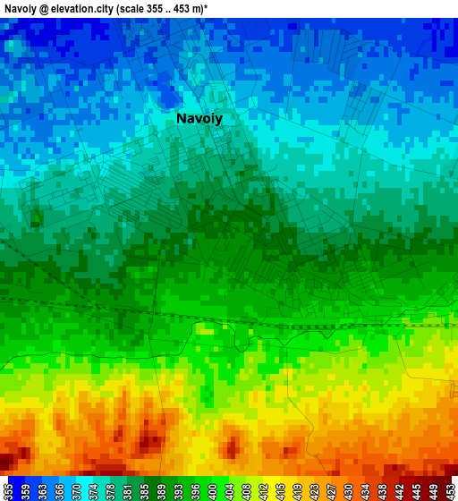
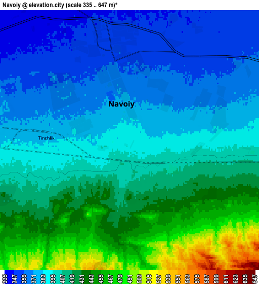
Below is the Elevation map of Navoiy, which displays elevation range with different colors. Scale of the first map is from 355 to 453 m (1165 to 1486 ft) with average elevation of 389.5 meters (=1278 ft) [note 1]
These maps also provides idea of topography and contour of this city, they are displayed at different zoom levels. More info about maps, scale and edge coordinates you can find below images.
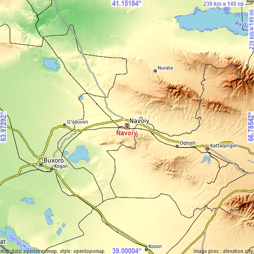
| \ | Map #1 | Map #2 | Topo.Map |
| Scale [m] | 355..453 m | 335..647 m | × |
| Scale [ft] | 1165..1486 ft | 1099..2123 ft | × |
| Average | 389.5 m = 1278 ft | 402.9 m = 1322 ft | × |
| Width | 7.48 km = 4.6 mi | 14.95 km = 9.3 mi | 239.3 km = 148.7 mi |
| Height | 7.48 km = 4.6 mi | 14.95 km = 9.3 mi | 239.3 km = 148.7 mi |
| ↑Max Latitude | 40.118054° | 40.151652° | 41.15184° |
| Latitude at center | 40.08444° | 40.08444° | 40.08444° |
| ↓Min Latitude | 40.050809° | 40.017162° | 39.00004° |
| ← Min Longitude | 65.335225° | 65.291279° | 63.97292° |
| Longitude center | 65.37917° | 65.37917° | 65.37917° |
| →Max Longitude | 65.423115° | 65.467061° | 66.78542° |
Nearby cities:
Cities around Navoiy sort by population:
• Ghijduwon elevation 261 m
59.2 km,  271°
271°
• Oqtosh 462 m
49.9 km,  111°
111°
• Nurota 493 m
59.2 km,  26°
26°
• Yangirabot 418 m
49.9 km,  97°
97°
• Payshanba 468 m
73.5 km, 96°
• Wobkent 243 m
73.8 km, 265°
• Qiziltepa 265 m
45.4 km,  262°
262°
• Nurota Shahri 497 m
59.5 km, 25°
• Qiziltepa Shahri 261 m
47.3 km, 262°
• Konimex 323 m
29.1 km,  316°
316°
• Beshrabot 336 m
13.1 km,  343°
343°
• Karmana Shahri 350 m
5.9 km,  356°
356°
Multilingual:
 En español:
Navoiy elevación 392 m.
 En France:
Navoï élévation 392 m.


Sources and notes:
- [note 1] Map square and city borders are not equal. Map elevation data is calculated only from area inside that square.
- [src 1] Elevation data from geonames database provided with same terms of usage.
- [src 2] The elevation map of Navoiy is generated using elevation data from NASA's 3 arcsec (90m) resolution SRTM data.
- [src 3] Base (background) map © OpenStreetMap contributors tiles are generated by Geofabrik and OpenTopoMap.
Copyright & License:
This Navoiy Elevation Map is licensed under CC BY-SA. You may reuse any part from this page, if you give a proper credit by linking to this URL:
 More info on terms of use page.