Wobkent elevation
Wobkent (Bukhara), Uzbekistan elevation is 243 meters and Wobkent elevation in feet is 797 ft above sea level [src 1]. Wobkent is a populated place (feature code) with elevation that is 186 meters (610 ft) smaller than average city elevation in Uzbekistan.
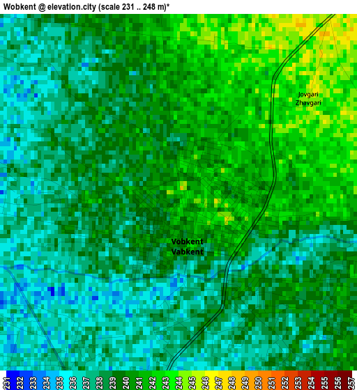
Below is the Elevation map of Wobkent, which displays elevation range with different colors. Scale of the first map is from 231 to 248 m (758 to 814 ft) with average elevation of 238.9 meters (=784 ft) [note 1]
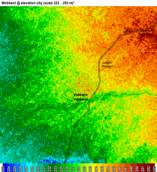
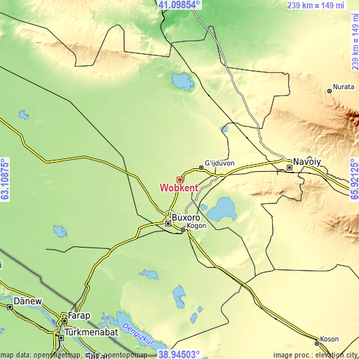
These maps also provides idea of topography and contour of this city, they are displayed at different zoom levels. More info about maps, scale and edge coordinates you can find below images.
| \ | Map #1 | Map #2 | Topo.Map |
| Scale [m] | 231..248 m | 223..253 m | × |
| Scale [ft] | 758..814 ft | 732..830 ft | × |
| Average | 238.9 m = 784 ft | 238.2 m = 781 ft | × |
| Width | 7.48 km = 4.6 mi | 14.97 km = 9.3 mi | 239.4 km = 148.8 mi |
| Height | 7.48 km = 4.6 mi | 14.97 km = 9.3 mi | 239.4 km = 148.8 mi |
| ↑Max Latitude | 40.063921° | 40.097545° | 41.09854° |
| Latitude at center | 40.03028° | 40.03028° | 40.03028° |
| ↓Min Latitude | 39.996623° | 39.962949° | 38.94503° |
| ← Min Longitude | 64.471055° | 64.427109° | 63.10875° |
| Longitude center | 64.515° | 64.515° | 64.515° |
| →Max Longitude | 64.558945° | 64.602891° | 65.92125° |
Nearby cities:
Cities around Wobkent sort by population:
• Bukhara elevation 229 m
29.4 km,  194°
194°
• Kogon 224 m
34.3 km,  174°
174°
• Ghijduwon 261 m
16.3 km,  61°
61°
• Shofirkon 245 m
10 km,  353°
353°
• Galaosiyo 228 m
20 km,  196°
196°
• Qiziltepa 265 m
28.5 km,  89°
89°
• Romiton 228 m
16.1 km,  225°
225°
• Qorovulbozor 251 m
63.5 km,  157°
157°
• Beshrabot 336 m
72.2 km,  75°
75°
• Qorovulbozor Shahri 252 m
63.9 km, 156°
• Konimex 323 m
60.1 km, 62°
• Qiziltepa Shahri 261 m
26.7 km, 91°
Multilingual:
 En español:
Wobkent elevación 243 m.
 En France:
Wobkent élévation 243 m.


Sources and notes:
- [note 1] Map square and city borders are not equal. Map elevation data is calculated only from area inside that square.
- [src 1] Elevation data from geonames database provided with same terms of usage.
- [src 2] The elevation map of Wobkent is generated using elevation data from NASA's 3 arcsec (90m) resolution SRTM data.
- [src 3] Base (background) map © OpenStreetMap contributors tiles are generated by Geofabrik and OpenTopoMap.
Copyright & License:
This Wobkent Elevation Map is licensed under CC BY-SA. You may reuse any part from this page, if you give a proper credit by linking to this URL:
 More info on terms of use page.