Qo‘qon elevation
Qo‘qon (Fergana), Uzbekistan elevation is 416 meters and Qo‘qon elevation in feet is 1365 ft above sea level [src 1]. Qo‘qon is a populated place (feature code) with elevation that is 13 meters (43 ft) smaller than average city elevation in Uzbekistan.
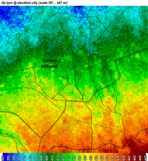
Below is the Elevation map of Qo‘qon, which displays elevation range with different colors. Scale of the first map is from 391 to 447 m (1283 to 1467 ft) with average elevation of 417 meters (=1368 ft) [note 1]
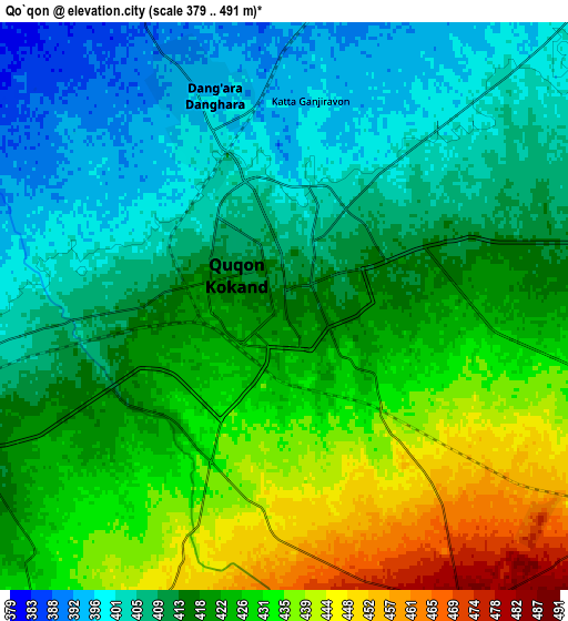
These maps also provides idea of topography and contour of this city, they are displayed at different zoom levels. More info about maps, scale and edge coordinates you can find below images.
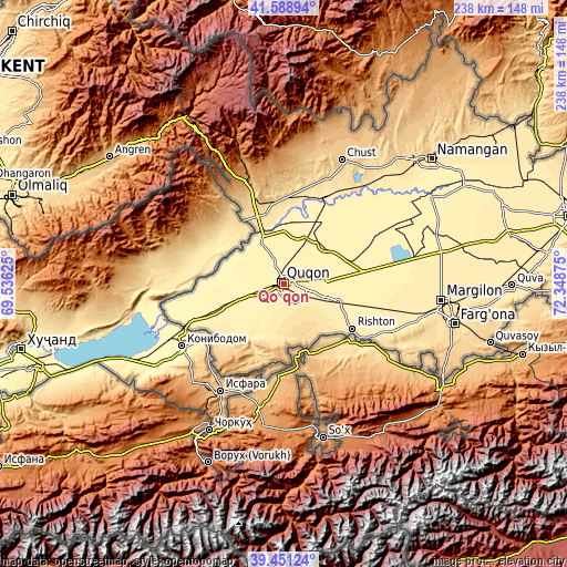
| \ | Map #1 | Map #2 | Topo.Map |
| Scale [m] | 391..447 m | 379..491 m | × |
| Scale [ft] | 1283..1467 ft | 1243..1611 ft | × |
| Average | 417 m = 1368 ft | 418.5 m = 1373 ft | × |
| Width | 7.43 km = 4.6 mi | 14.86 km = 9.2 mi | 237.7 km = 147.7 mi |
| Height | 7.43 km = 4.6 mi | 14.86 km = 9.2 mi | 237.7 km = 147.7 mi |
| ↑Max Latitude | 40.562004° | 40.595381° | 41.58894° |
| Latitude at center | 40.52861° | 40.52861° | 40.52861° |
| ↓Min Latitude | 40.4952° | 40.461773° | 39.45124° |
| ← Min Longitude | 70.898555° | 70.854609° | 69.53625° |
| Longitude center | 70.9425° | 70.9425° | 70.9425° |
| →Max Longitude | 70.986445° | 71.030391° | 72.34875° |
Nearby cities:
Cities around Qo‘qon sort by population:
• Oltiariq elevation 463 m
47.5 km,  108°
108°
• Pop 440 m
40.8 km,  20°
20°
• Beshariq 393 m
29.9 km,  249°
249°
• Yaypan 446 m
20.1 km,  212°
212°
• Hamza 443 m
48.9 km,  103°
103°
• Pop Shahri 450 m
40.9 km, 19°
• Rishton 479 m
34.7 km,  123°
123°
• Bag‘dod 419 m
23.9 km, 107°
• Yangiqo‘rg‘on 405 m
17.5 km,  80°
80°
• Navbahor 400 m
15.4 km, 249°
• Uchko‘prik 414 m
10.1 km, 81°
• Dang‘ara 393 m
6.6 km,  338°
338°
Multilingual:
 En español:
Qo‘qon elevación 416 m.
 En France:
Kokand élévation 416 m.
 Auf Deutsch:
Qoʻqon, Kokand höhe über dem Meeresspiegel ist 416 m.

Sources and notes:
- [note 1] Map square and city borders are not equal. Map elevation data is calculated only from area inside that square.
- [src 1] Elevation data from geonames database provided with same terms of usage.
- [src 2] The elevation map of Qo‘qon is generated using elevation data from NASA's 3 arcsec (90m) resolution SRTM data.
- [src 3] Base (background) map © OpenStreetMap contributors tiles are generated by Geofabrik and OpenTopoMap.
Copyright & License:
This Qo‘qon Elevation Map is licensed under CC BY-SA. You may reuse any part from this page, if you give a proper credit by linking to this URL:
 More info on terms of use page.