Beshkent elevation
Beshkent (Qashqadaryo), Uzbekistan elevation is 355 meters and Beshkent elevation in feet is 1165 ft above sea level [src 1]. Beshkent is a populated place (feature code) with elevation that is 74 meters (243 ft) smaller than average city elevation in Uzbekistan.
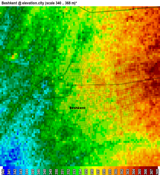
Below is the Elevation map of Beshkent, which displays elevation range with different colors. Scale of the first map is from 340 to 368 m (1115 to 1207 ft) with average elevation of 354.1 meters (=1162 ft) [note 1]
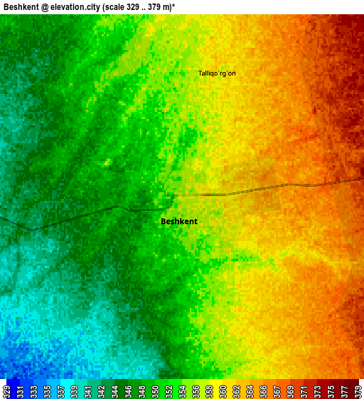
These maps also provides idea of topography and contour of this city, they are displayed at different zoom levels. More info about maps, scale and edge coordinates you can find below images.
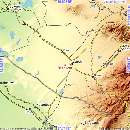
| \ | Map #1 | Map #2 | Topo.Map |
| Scale [m] | 340..368 m | 329..379 m | × |
| Scale [ft] | 1115..1207 ft | 1079..1243 ft | × |
| Average | 354.1 m = 1162 ft | 354.3 m = 1162 ft | × |
| Width | 7.61 km = 4.7 mi | 15.23 km = 9.5 mi | 243.6 km = 151.4 mi |
| Height | 7.61 km = 4.7 mi | 15.23 km = 9.5 mi | 243.6 km = 151.4 mi |
| ↑Max Latitude | 38.85562° | 38.889833° | 39.90855° |
| Latitude at center | 38.82139° | 38.82139° | 38.82139° |
| ↓Min Latitude | 38.787144° | 38.752881° | 37.71737° |
| ← Min Longitude | 65.609115° | 65.565169° | 64.24681° |
| Longitude center | 65.65306° | 65.65306° | 65.65306° |
| →Max Longitude | 65.697005° | 65.740951° | 67.05931° |
Nearby cities:
Cities around Beshkent sort by population:
• Qarshi elevation 383 m
12.6 km,  69°
69°
• Koson 347 m
24.7 km,  346°
346°
• Muborak 290 m
64.8 km,  318°
318°
• G‘uzor 524 m
56.2 km,  113°
113°
• Nishon Tumani 349 m
14.3 km,  172°
172°
• Muborak Shahri 289 m
64.7 km, 318°
• G‘uzor Shahri 517 m
55.8 km, 112°
• Yangi Mirishkor 310 m
32.7 km,  275°
275°
• Koson Shahri 344 m
25.4 km, 347°
• Mug‘lon Shahar 327 m
23.5 km,  297°
297°
• Yangi-Nishon Shahri 353 m
19.9 km, 170°
• Beshkent Shahri 353 m
1.5 km,  218°
218°
Multilingual:
 En español:
Beshkent elevación 355 m.
 En France:
Beshkent élévation 355 m.
 Auf Deutsch:
Beshkent höhe über dem Meeresspiegel ist 355 m.

Sources and notes:
- [note 1] Map square and city borders are not equal. Map elevation data is calculated only from area inside that square.
- [src 1] Elevation data from geonames database provided with same terms of usage.
- [src 2] The elevation map of Beshkent is generated using elevation data from NASA's 3 arcsec (90m) resolution SRTM data.
- [src 3] Base (background) map © OpenStreetMap contributors tiles are generated by Geofabrik and OpenTopoMap.
Copyright & License:
This Beshkent Elevation Map is licensed under CC BY-SA. You may reuse any part from this page, if you give a proper credit by linking to this URL:
 More info on terms of use page.