G‘uzor elevation
G‘uzor (Qashqadaryo), Uzbekistan elevation is 524 meters and G‘uzor elevation in feet is 1719 ft above sea level [src 1]. G‘uzor is a populated place (feature code) with elevation that is 95 meters (312 ft) bigger than average city elevation in Uzbekistan.
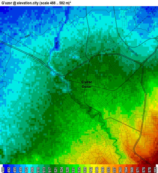
Below is the Elevation map of G‘uzor, which displays elevation range with different colors. Scale of the first map is from 488 to 582 m (1601 to 1909 ft) with average elevation of 517.9 meters (=1699 ft) [note 1]
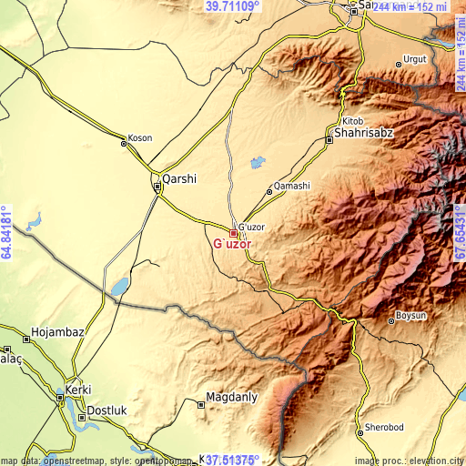
These maps also provides idea of topography and contour of this city, they are displayed at different zoom levels. More info about maps, scale and edge coordinates you can find below images.
| \ | Map #1 | Map #2 | Topo.Map |
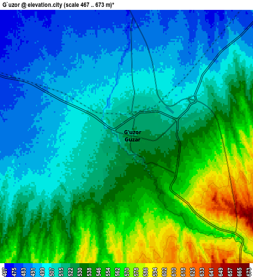
| Scale [m] | 488..582 m | 467..673 m | × |
| Scale [ft] | 1601..1909 ft | 1532..2208 ft | × |
| Average | 517.9 m = 1699 ft | 524.8 m = 1722 ft | × |
| Width | 7.64 km = 4.7 mi | 15.27 km = 9.5 mi | 244.3 km = 151.8 mi |
| Height | 7.64 km = 4.7 mi | 15.27 km = 9.5 mi | 244.3 km = 151.8 mi |
| ↑Max Latitude | 38.655156° | 38.689466° | 39.71109° |
| Latitude at center | 38.62083° | 38.62083° | 38.62083° |
| ↓Min Latitude | 38.586488° | 38.552129° | 37.51375° |
| ← Min Longitude | 66.204115° | 66.160169° | 64.84181° |
| Longitude center | 66.24806° | 66.24806° | 66.24806° |
| →Max Longitude | 66.292005° | 66.335951° | 67.65431° |
Nearby cities:
Cities around G‘uzor sort by population:
• Qarshi elevation 383 m
47.9 km,  303°
303°
• Chiroqchi 524 m
53.8 km,  31°
31°
• Beshkent 355 m
56.2 km,  293°
293°
• Nishon Tumani 349 m
50.4 km,  279°
279°
• Shahrisabz Shahri 622 m
69 km,  45°
45°
• Beshkent Shahri 353 m
56.6 km, 291°
• Yakkabog‘ Shahri 587 m
55 km,  43°
43°
• Chiroqchi Shahri 529 m
53.6 km, 32°
• Yangi-Nishon Shahri 353 m
48.6 km,  273°
273°
• Qorashina 939 m
41.4 km,  138°
138°
• Qamashi Shahri 520 m
29 km, 40°
• G‘uzor Shahri 517 m
0.6 km,  336°
336°
Multilingual:
 En español:
G‘uzor elevación 524 m.
 En France:
G‘uzor élévation 524 m.


Sources and notes:
- [note 1] Map square and city borders are not equal. Map elevation data is calculated only from area inside that square.
- [src 1] Elevation data from geonames database provided with same terms of usage.
- [src 2] The elevation map of G‘uzor is generated using elevation data from NASA's 3 arcsec (90m) resolution SRTM data.
- [src 3] Base (background) map © OpenStreetMap contributors tiles are generated by Geofabrik and OpenTopoMap.
Copyright & License:
This G‘uzor Elevation Map is licensed under CC BY-SA. You may reuse any part from this page, if you give a proper credit by linking to this URL:
 More info on terms of use page.