Karakul’ elevation
Karakul’ (Bukhara), Uzbekistan elevation is 199 meters and Karakul’ elevation in feet is 653 ft above sea level [src 1]. Karakul’ is a populated place (feature code) with elevation that is 230 meters (755 ft) smaller than average city elevation in Uzbekistan.
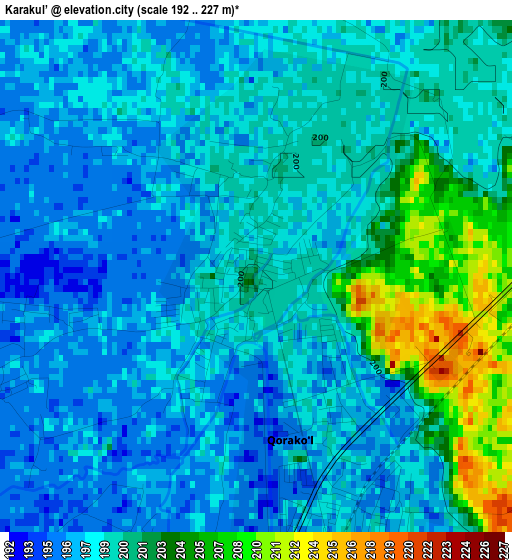
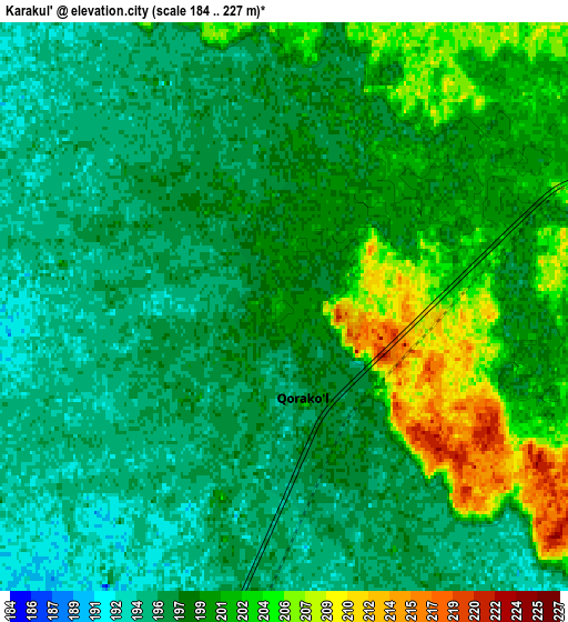
Below is the Elevation map of Karakul’, which displays elevation range with different colors. Scale of the first map is from 192 to 227 m (630 to 745 ft) with average elevation of 199.3 meters (=654 ft) [note 1]
These maps also provides idea of topography and contour of this city, they are displayed at different zoom levels. More info about maps, scale and edge coordinates you can find below images.
| \ | Map #1 | Map #2 | Topo.Map |
| Scale [m] | 192..227 m | 184..227 m | × |
| Scale [ft] | 630..745 ft | 604..745 ft | × |
| Average | 199.3 m = 654 ft | 198.5 m = 651 ft | × |
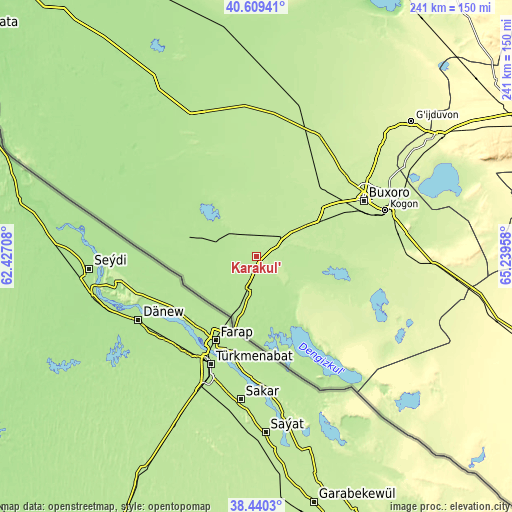
| Width | 7.54 km = 4.7 mi | 15.07 km = 9.4 mi | 241.2 km = 149.9 mi |
| Height | 7.54 km = 4.7 mi | 15.07 km = 9.4 mi | 241.2 km = 149.9 mi |
| ↑Max Latitude | 39.567215° | 39.601083° | 40.60941° |
| Latitude at center | 39.53333° | 39.53333° | 39.53333° |
| ↓Min Latitude | 39.499429° | 39.465511° | 38.4403° |
| ← Min Longitude | 63.789385° | 63.745439° | 62.42708° |
| Longitude center | 63.83333° | 63.83333° | 63.83333° |
| →Max Longitude | 63.877275° | 63.921221° | 65.23958° |
Nearby cities:
Cities around Karakul’ sort by population:
• Bukhara elevation 229 m
57.6 km,  62°
62°
• Kogon 224 m
65 km,  71°
71°
• Ghijduwon 261 m
96.1 km,  49°
49°
• Shofirkon 245 m
86.7 km,  41°
41°
• Wobkent 243 m
80.3 km, 46°
• Galaosiyo 228 m
63.8 km, 55°
• Romiton 228 m
64.2 km, 46°
• Olot 197 m
13.4 km,  191°
191°
• Gazli 187 m
74.3 km,  333°
333°
• Qorovulbozor 251 m
82.4 km,  92°
92°
• Qorovulbozor Shahri 252 m
84 km, 92°
• Qorako’l 198 m
4.2 km,  154°
154°
Multilingual:
 En español:
Karakul’ elevación 199 m.
 En France:
Karakul’ élévation 199 m.
 Auf Deutsch:
Karakul’ höhe über dem Meeresspiegel ist 199 m.

Sources and notes:
- [note 1] Map square and city borders are not equal. Map elevation data is calculated only from area inside that square.
- [src 1] Elevation data from geonames database provided with same terms of usage.
- [src 2] The elevation map of Karakul’ is generated using elevation data from NASA's 3 arcsec (90m) resolution SRTM data.
- [src 3] Base (background) map © OpenStreetMap contributors tiles are generated by Geofabrik and OpenTopoMap.
Copyright & License:
This Karakul’ Elevation Map is licensed under CC BY-SA. You may reuse any part from this page, if you give a proper credit by linking to this URL:
 More info on terms of use page.