Tirmiz elevation
Tirmiz (Surxondaryo), Uzbekistan elevation is 304 meters and Tirmiz elevation in feet is 997 ft above sea level [src 1]. Tirmiz is a seat of a first-order administrative division (feature code) with elevation that is 125 meters (410 ft) smaller than average city elevation in Uzbekistan.
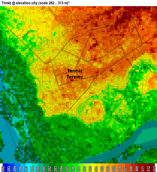
Below is the Elevation map of Tirmiz, which displays elevation range with different colors. Scale of the first map is from 282 to 313 m (925 to 1027 ft) with average elevation of 298.6 meters (=980 ft) [note 1]
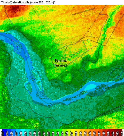
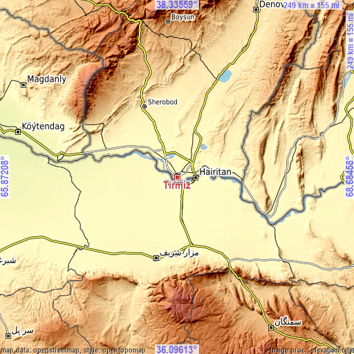
These maps also provides idea of topography and contour of this city, they are displayed at different zoom levels. More info about maps, scale and edge coordinates you can find below images.
| \ | Map #1 | Map #2 | Topo.Map |
| Scale [m] | 282..313 m | 282..325 m | × |
| Scale [ft] | 925..1027 ft | 925..1066 ft | × |
| Average | 298.6 m = 980 ft | 299.7 m = 983 ft | × |
| Width | 7.78 km = 4.8 mi | 15.56 km = 9.7 mi | 249 km = 154.7 mi |
| Height | 7.78 km = 4.8 mi | 15.56 km = 9.7 mi | 249 km = 154.7 mi |
| ↑Max Latitude | 37.259154° | 37.294123° | 38.33559° |
| Latitude at center | 37.22417° | 37.22417° | 37.22417° |
| ↓Min Latitude | 37.189169° | 37.154152° | 36.09613° |
| ← Min Longitude | 67.234385° | 67.190439° | 65.87208° |
| Longitude center | 67.27833° | 67.27833° | 67.27833° |
| →Max Longitude | 67.322275° | 67.366221° | 68.68458° |
Nearby cities:
Cities around Tirmiz sort by population:
• Denov elevation 525 m
128.2 km,  25°
25°
• Shahrisabz 631 m
207.5 km,  349°
349°
• G‘uzor 524 m
179.7 km,  329°
329°
• Boysun 1240 m
109.6 km,  356°
356°
• Sho‘rchi 450 m
97.2 km, 27°
• Chiroqchi 524 m
210.5 km,  342°
342°
• Chiroqchi Shahri 529 m
209.6 km, 343°
• Shahrisabz Shahri 622 m
207.1 km, 348°
• Yakkabog‘ Shahri 587 m
201.6 km, 345°
• Qamashi Shahri 520 m
191.2 km, 338°
• G‘uzor Shahri 517 m
180.3 km, 329°
• Qorashina 939 m
139.3 km, 333°
Multilingual:
 En español:
Termez elevación 304 m.
 En France:
Termez élévation 304 m.


Sources and notes:
- [note 1] Map square and city borders are not equal. Map elevation data is calculated only from area inside that square.
- [src 1] Elevation data from geonames database provided with same terms of usage.
- [src 2] The elevation map of Tirmiz is generated using elevation data from NASA's 3 arcsec (90m) resolution SRTM data.
- [src 3] Base (background) map © OpenStreetMap contributors tiles are generated by Geofabrik and OpenTopoMap.
Copyright & License:
This Tirmiz Elevation Map is licensed under CC BY-SA. You may reuse any part from this page, if you give a proper credit by linking to this URL:
 More info on terms of use page.