Bay Harbor elevation
Bay Harbor (Michigan, Emmet County), United States elevation is 201 meters and Bay Harbor elevation in feet is 659 ft above sea level [src 1]. Bay Harbor is a populated place (feature code) with elevation that is 78 meters (256 ft) smaller than average city elevation in United States.
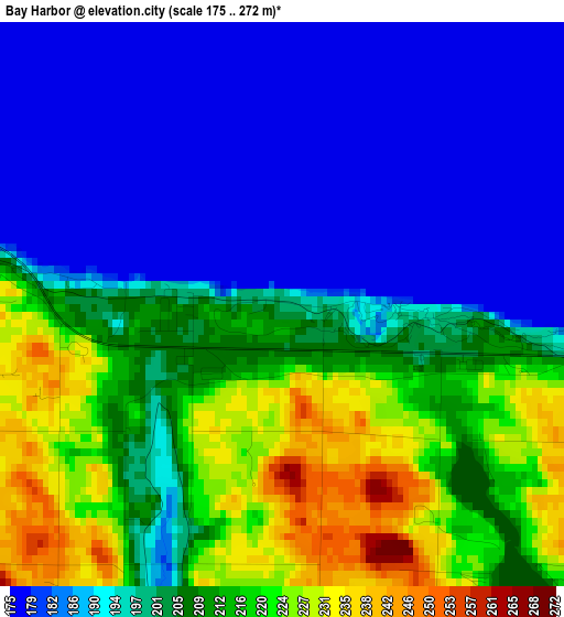
Below is the Elevation map of Bay Harbor, which displays elevation range with different colors. Scale of the first map is from 175 to 272 m (574 to 892 ft) with average elevation of 200.2 meters (=657 ft) [note 1]
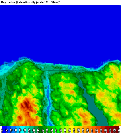
These maps also provides idea of topography and contour of this city, they are displayed at different zoom levels. More info about maps, scale and edge coordinates you can find below images.
| \ | Map #1 | Map #2 | Topo.Map |
| Scale [m] | 175..272 m | 171..314 m | × |
| Scale [ft] | 574..892 ft | 561..1030 ft | × |
| Average | 200.2 m = 657 ft | 204.8 m = 672 ft | × |
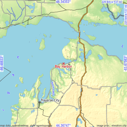
| Width | 6.87 km = 4.3 mi | 13.73 km = 8.5 mi | 219.7 km = 136.5 mi |
| Height | 6.87 km = 4.3 mi | 13.73 km = 8.5 mi | 219.7 km = 136.5 mi |
| ↑Max Latitude | 45.394997° | 45.425848° | 46.34353° |
| Latitude at center | 45.36413° | 45.36413° | 45.36413° |
| ↓Min Latitude | 45.333246° | 45.302344° | 44.36747° |
| ← Min Longitude | -85.126025° | -85.169971° | -86.48833° |
| Longitude center | -85.08208° | -85.08208° | -85.08208° |
| →Max Longitude | -85.038135° | -84.994189° | -83.67583° |
Nearby cities:
Cities around Bay Harbor sort by population:
• Petoskey elevation 204 m
10 km,  84°
84°
• Cheboygan 177 m
56.8 km,  56°
56°
• Boyne City 176 m
17.2 km,  161°
161°
• Gaylord 410 m
49.2 km,  139°
139°
• Charlevoix 176 m
14.7 km,  249°
249°
• East Jordan 198 m
23.1 km,  188°
188°
• Indian River 185 m
37.1 km, 81°
• Elk Rapids 183 m
58.3 km,  206°
206°
• Mancelona 340 m
51.4 km,  178°
178°
• Rapid City 190 m
61 km, 194°
• Harbor Springs 199 m
10.3 km,  43°
43°
• Bellaire 190 m
43.9 km, 193°
Multilingual:
 En español:
Bay Harbor elevación 201 m.
 En France:
Bay Harbor élévation 201 m.
 Auf Deutsch:
Bay Harbor höhe über dem Meeresspiegel ist 201 m.

Sources and notes:
- [note 1] Map square and city borders are not equal. Map elevation data is calculated only from area inside that square.
- [src 1] Elevation data from geonames database provided with same terms of usage.
- [src 2] The elevation map of Bay Harbor is generated using elevation data from NASA's 3 arcsec (90m) resolution SRTM data.
- [src 3] Base (background) map © OpenStreetMap contributors tiles are generated by Geofabrik and OpenTopoMap.
Copyright & License:
This Bay Harbor Elevation Map is licensed under CC BY-SA. You may reuse any part from this page, if you give a proper credit by linking to this URL:
 More info on terms of use page.