Cherry Creek elevation
Cherry Creek (Colorado, Arapahoe County), United States elevation is 1726 meters and Cherry Creek elevation in feet is 5663 ft above sea level [src 1]. Cherry Creek is a populated place (feature code) with elevation that is 1447 meters (4747 ft) bigger than average city elevation in United States.
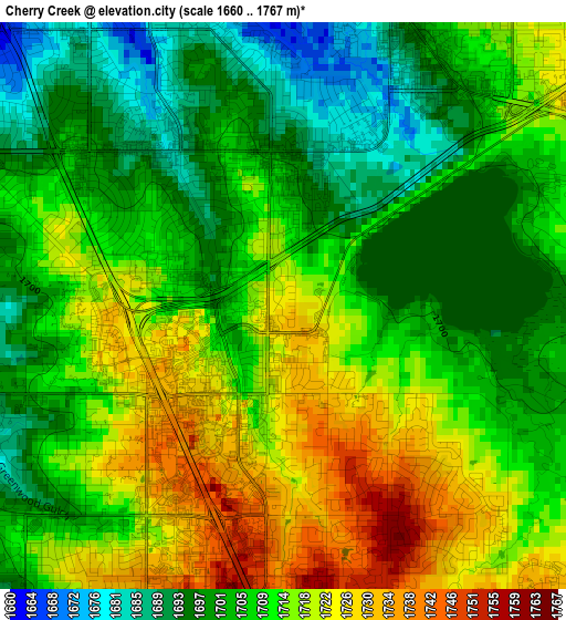
Below is the Elevation map of Cherry Creek, which displays elevation range with different colors. Scale of the first map is from 1660 to 1767 m (5446 to 5797 ft) with average elevation of 1709.2 meters (=5608 ft) [note 1]
These maps also provides idea of topography and contour of this city, they are displayed at different zoom levels. More info about maps, scale and edge coordinates you can find below images.
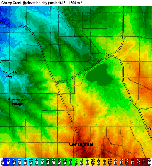
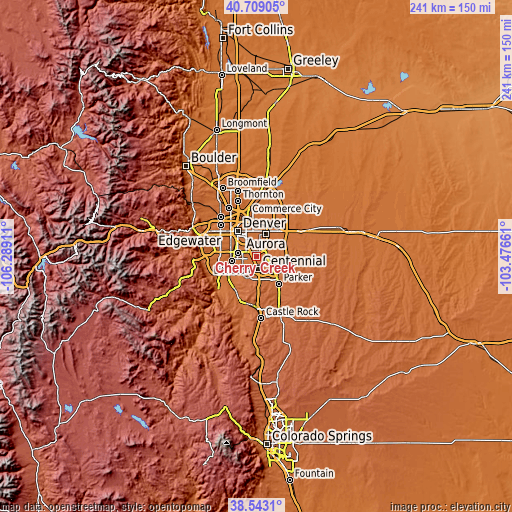
| \ | Map #1 | Map #2 | Topo.Map |
| Scale [m] | 1660..1767 m | 1616..1806 m | × |
| Scale [ft] | 5446..5797 ft | 5302..5925 ft | × |
| Average | 1709.2 m = 5608 ft | 1706.8 m = 5600 ft | × |
| Width | 7.53 km = 4.7 mi | 15.05 km = 9.4 mi | 240.8 km = 149.6 mi |
| Height | 7.53 km = 4.7 mi | 15.05 km = 9.4 mi | 240.8 km = 149.6 mi |
| ↑Max Latitude | 39.668385° | 39.702204° | 40.70905° |
| Latitude at center | 39.63455° | 39.63455° | 39.63455° |
| ↓Min Latitude | 39.600698° | 39.56683° | 38.5431° |
| ← Min Longitude | -104.926805° | -104.970751° | -106.28911° |
| Longitude center | -104.88286° | -104.88286° | -104.88286° |
| →Max Longitude | -104.838915° | -104.794969° | -103.47661° |
Nearby cities:
Cities around Cherry Creek sort by population:
• Centennial elevation 1781 m
6.2 km,  175°
175°
• Southglenn 1710 m
8 km,  228°
228°
• Englewood 1642 m
9.1 km,  279°
279°
• Castlewood 1750 m
5.8 km,  195°
195°
• Greenwood Village 1674 m
6.1 km,  251°
251°
• Lone Tree 1779 m
9.2 km, 181°
• Cherry Hills Village 1658 m
6.6 km, 276°
• Dove Valley 1754 m
7.8 km,  144°
144°
• Glendale 1638 m
9 km,  330°
330°
• Acres Green 1783 m
8.7 km,  187°
187°
• Holly Hills 1681 m
4.7 km,  320°
320°
• Inverness 1764 m
6.6 km,  163°
163°
Multilingual:
 En español:
Cherry Creek elevación 1726 m.
 En France:
Cherry Creek élévation 1726 m.
 Auf Deutsch:
Cherry Creek höhe über dem Meeresspiegel ist 1726 m.

Sources and notes:
- [note 1] Map square and city borders are not equal. Map elevation data is calculated only from area inside that square.
- [src 1] Elevation data from geonames database provided with same terms of usage.
- [src 2] The elevation map of Cherry Creek is generated using elevation data from NASA's 3 arcsec (90m) resolution SRTM data.
- [src 3] Base (background) map © OpenStreetMap contributors tiles are generated by Geofabrik and OpenTopoMap.
Copyright & License:
This Cherry Creek Elevation Map is licensed under CC BY-SA. You may reuse any part from this page, if you give a proper credit by linking to this URL:
 More info on terms of use page.