Port Hadlock-Irondale elevation
Port Hadlock-Irondale (Washington, Jefferson County), United States elevation is 39 meters and Port Hadlock-Irondale elevation in feet is 128 ft above sea level [src 1]. Port Hadlock-Irondale is a populated place (feature code) with elevation that is 240 meters (787 ft) smaller than average city elevation in United States.
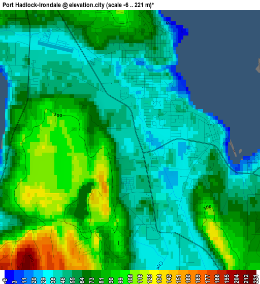
Below is the Elevation map of Port Hadlock-Irondale, which displays elevation range with different colors. Scale of the first map is from -6 to 221 m (-20 to 725 ft) with average elevation of 69.7 meters (=229 ft) [note 1]
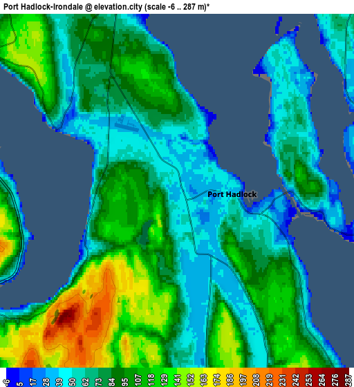
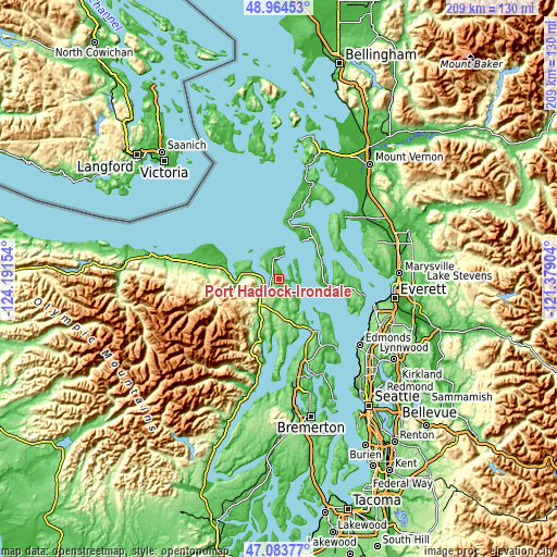
These maps also provides idea of topography and contour of this city, they are displayed at different zoom levels. More info about maps, scale and edge coordinates you can find below images.
| \ | Map #1 | Map #2 | Topo.Map |
| Scale [m] | -6..221 m | -6..287 m | × |
| Scale [ft] | -20..725 ft | -20..942 ft | × |
| Average | 69.7 m = 229 ft | 87.5 m = 287 ft | × |
| Width | 6.53 km = 4.1 mi | 13.07 km = 8.1 mi | 209.1 km = 129.9 mi |
| Height | 6.53 km = 4.1 mi | 13.07 km = 8.1 mi | 209.1 km = 129.9 mi |
| ↑Max Latitude | 48.062108° | 48.091469° | 48.96453° |
| Latitude at center | 48.03273° | 48.03273° | 48.03273° |
| ↓Min Latitude | 48.003335° | 47.973923° | 47.08377° |
| ← Min Longitude | -122.829235° | -122.873181° | -124.19154° |
| Longitude center | -122.78529° | -122.78529° | -122.78529° |
| →Max Longitude | -122.741345° | -122.697399° | -121.37904° |
Nearby cities:
Cities around Port Hadlock-Irondale sort by population:
• Oak Harbor elevation 27 m
30.8 km,  19°
19°
• Camano 17 m
24.7 km,  50°
50°
• Poulsbo 7 m
34.6 km,  162°
162°
• Port Townsend 42 m
9.6 km,  11°
11°
• Sequim 56 m
24.1 km,  282°
282°
• Hansville 9 m
21.4 km,  126°
126°
• Port Ludlow 19 m
14.1 km,  147°
147°
• Lofall 27 m
26.3 km, 158°
• Kingston 21 m
33.7 km,  140°
140°
• Freeland 34 m
19.5 km,  97°
97°
• Coupeville 23 m
22.1 km, 19°
• Langley 21 m
28.2 km,  88°
88°
Multilingual:
 En español:
Port Hadlock-Irondale elevación 39 m.
 En France:
Port Hadlock-Irondale élévation 39 m.
 Auf Deutsch:
Port Hadlock-Irondale höhe über dem Meeresspiegel ist 39 m.
 На русском:
Port Hadlock-Irondale высота над уровнем моря 39 м
Sources and notes:
- [note 1] Map square and city borders are not equal. Map elevation data is calculated only from area inside that square.
- [src 1] Elevation data from geonames database provided with same terms of usage.
- [src 2] The elevation map of Port Hadlock-Irondale is generated using elevation data from NASA's 3 arcsec (90m) resolution SRTM data.
- [src 3] Base (background) map © OpenStreetMap contributors tiles are generated by Geofabrik and OpenTopoMap.
Copyright & License:
This Port Hadlock-Irondale Elevation Map is licensed under CC BY-SA. You may reuse any part from this page, if you give a proper credit by linking to this URL:
 More info on terms of use page.