Helena Valley West Central elevation
Helena Valley West Central (Montana, Lewis and Clark County), United States elevation is 1279 meters and Helena Valley West Central elevation in feet is 4196 ft above sea level [src 1]. Helena Valley West Central is a populated place (feature code) with elevation that is 1000 meters (3281 ft) bigger than average city elevation in United States.
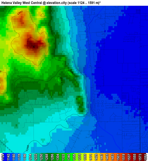
Below is the Elevation map of Helena Valley West Central, which displays elevation range with different colors. Scale of the first map is from 1124 to 1591 m (3688 to 5220 ft) with average elevation of 1219.9 meters (=4002 ft) [note 1]
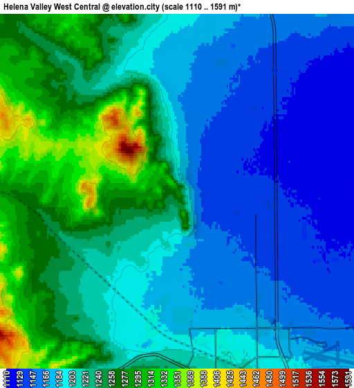
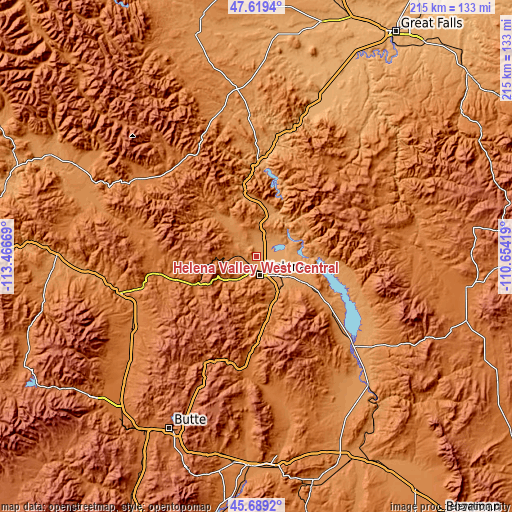
These maps also provides idea of topography and contour of this city, they are displayed at different zoom levels. More info about maps, scale and edge coordinates you can find below images.
| \ | Map #1 | Map #2 | Topo.Map |
| Scale [m] | 1124..1591 m | 1110..1591 m | × |
| Scale [ft] | 3688..5220 ft | 3642..5220 ft | × |
| Average | 1219.9 m = 4002 ft | 1213.1 m = 3980 ft | × |
| Width | 6.71 km = 4.2 mi | 13.41 km = 8.3 mi | 214.6 km = 133.3 mi |
| Height | 6.71 km = 4.2 mi | 13.41 km = 8.3 mi | 214.6 km = 133.3 mi |
| ↑Max Latitude | 46.693061° | 46.723195° | 47.6194° |
| Latitude at center | 46.66291° | 46.66291° | 46.66291° |
| ↓Min Latitude | 46.632742° | 46.602558° | 45.6892° |
| ← Min Longitude | -112.104385° | -112.148331° | -113.46669° |
| Longitude center | -112.06044° | -112.06044° | -112.06044° |
| →Max Longitude | -112.016495° | -111.972549° | -110.65419° |
Nearby cities:
Cities around Helena Valley West Central sort by population:
• Helena elevation 1236 m
8 km,  166°
166°
• Helena Valley Southeast 1156 m
11.9 km,  116°
116°
• Helena Valley Northwest 1208 m
7.3 km,  358°
358°
• Helena Valley Northeast 1110 m
9.2 km,  64°
64°
• Deer Lodge 1393 m
59.2 km,  239°
239°
• Montana City 1234 m
17 km,  144°
144°
• East Helena 1183 m
13.7 km,  126°
126°
• Townsend 1167 m
56.3 km, 132°
• Clancy 1294 m
22.7 km, 165°
• Helena West Side 1246 m
8.4 km,  208°
208°
• Boulder 1496 m
47.6 km,  185°
185°
• Lincoln 1384 m
57.4 km,  304°
304°
Multilingual:
 En español:
Helena Valley West Central elevación 1279 m.
 En France:
Helena Valley West Central élévation 1279 m.
 Auf Deutsch:
Helena Valley West Central höhe über dem Meeresspiegel ist 1279 m.
 На русском:
Helena Valley West Central высота над уровнем моря 1279 м
Sources and notes:
- [note 1] Map square and city borders are not equal. Map elevation data is calculated only from area inside that square.
- [src 1] Elevation data from geonames database provided with same terms of usage.
- [src 2] The elevation map of Helena Valley West Central is generated using elevation data from NASA's 3 arcsec (90m) resolution SRTM data.
- [src 3] Base (background) map © OpenStreetMap contributors tiles are generated by Geofabrik and OpenTopoMap.
Copyright & License:
This Helena Valley West Central Elevation Map is licensed under CC BY-SA. You may reuse any part from this page, if you give a proper credit by linking to this URL:
 More info on terms of use page.